← Back to Search Results

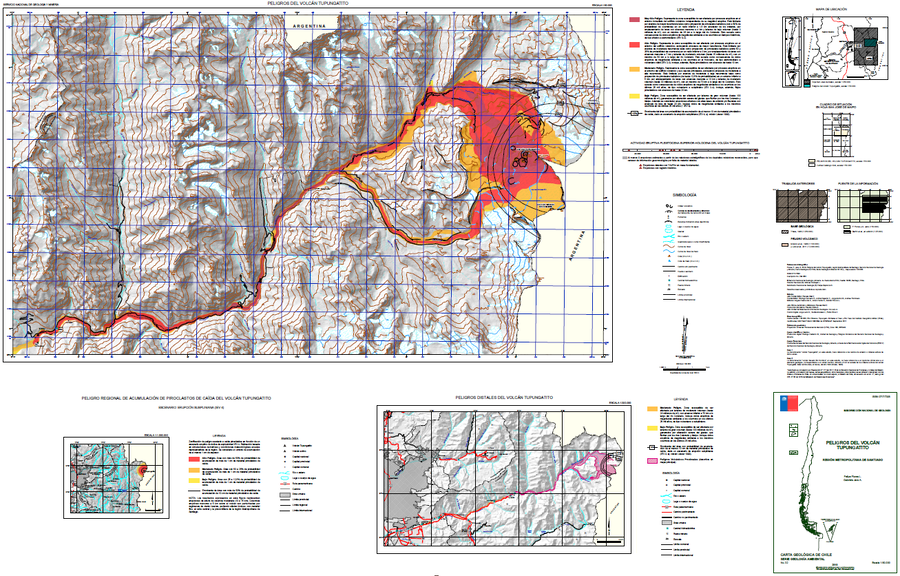
Peligros del Volcán Tupungatito

Hazards of Tupungatito Volcano

Tupungatito, Chile-Argentina, 2018

Flores, F. & Jara, G. (2018). Peligros volcán Tupungatito, Región Metropolitana de Santiago. Servicio Nacional de Geología y Minería (SERNAGEOMIN), Carta Geológica de Chile, Serie Geología Ambiental 32: 35 p., mapa escala 1:50.000. Santiago.


This map was produced by an official agency, but may not be the most recent, most complete, or main operational map. For the current operational hazard map, please consult the proper institutional authorities.


Click on image for full-size map.

Map Data

Map ID776
Hazard Process(es)Ballistics; Distal hazards; Lahars; Lava flows; PDCs; Proximal hazards; Tephra fall
Hazard Zone PresentationHazard level-focused: All or most hazards are combined by hazard level on a main map and series of insets
Temporal ScaleBackground, or long-term, map
Spatial ScaleVolcano and surrounding area
Publication FormatPoster-style map insert in hazard assessment
Zonation Method(s)Probabilistic modeling; Scenario modeling
Zonation Model(s)Ballistics (Bertin 2017); Eject! (Mastin 2001); Energy cone or line (Heim 1932; Sheridan 1979; Sheridan & Malin 1983); LAHARZ or modified version (such as PFZ) (Iverson et al. 1998; Schilling 1998; Schilling 2014); Q-LavHa (Mossoux et al. 2016); Tephra2 (Bonadonna et al. 2005; Bonadonna et al. 2010; Connor et al. 2011)
Scenario(s) ConsideredSeason or weather; Size, VEI, or intensity; Style or type
Hazard Zone Label(s)Location or source name; Numeric probability; Qualitative relative probability (e.g. high-medium-low)
Probability Definition(s)Annual numeric probability; Numeric probability; Qualitative relative probability (e.g. high-medium-low)
PurposeMultiple: intended for multiple purposes including general hazard awareness, planning, and crisis management
AudienceMultiple audiences (usually the public, civil authorities, and land-use planners)
Language(s)Spanish
Basemap(s)Hillshade
Basemap overlay(s)Contour lines; Street map
DiemsionalityPlanimetric (2D or map) view
Color SchemeRed to Yellow
Go to Global Volcanism Program page for Tupungatito →