← Back to Search Results

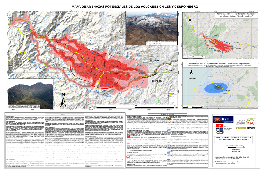
Mapa de Amenazas Potenciales de los Volcanes Chiles y Cerro Negro

Map of Potential Hazards of Chiles y Cerro Negro Volcanos

Chiles-Cerro Negro, Colombia-Ecuador, 2014

Servicio Geológco Colombiano (SGC) & Instituto Geofísico de la Escuela Politécnica Nacional (IG-EPN). (2014). Mapa de Amenazas Potenciales de los Volcanes Chiles Y Cerro Negro.


This map was produced by an official agency, but may not be the most recent, most complete, or main operational map. For the current operational hazard map, please consult the proper institutional authorities.


Click on image for full-size map. If link seems broken, try the archived version.

Map Data

Map ID804
Hazard Process(es)Ballistics; Debris avalanches; Lahars; Lava flows; PDCs; Tephra fall
Hazard Zone PresentationHazard process-focused: Most hazard processes are separated by hazard process type on a main map and series of insets
Temporal ScaleBackground, or long-term, map
Spatial ScaleVolcano and surrounding area
Publication FormatMap sheet or poster
Zonation Method(s)Probabilistic modeling; Scenario modeling
Zonation Model(s)Eject! (Mastin 2001); Energy cone or line (Heim 1932; Sheridan 1979; Sheridan & Malin 1983); LAHARZ or modified version (such as PFZ) (Iverson et al. 1998; Schilling 1998; Schilling 2014); LavaPL (Connor et al. 2012); Tephra2 (Bonadonna et al. 2005; Bonadonna et al. 2010; Connor et al. 2011); TITAN2D (Pitman et al. 2003; Patra et al. 2005); VolcFlow (Kelfoun & Druitt 2005)
Scenario(s) ConsideredSeason or weather; Size, VEI, or intensity
Hazard Zone Label(s)Estimated value or Hazard Impact Metric; Scenario name
Probability Definition(s)Qualitative relative probability (e.g. high-medium-low); Scenarios imply probability
PurposeMultiple: intended for multiple purposes including general hazard awareness, planning, and crisis management
AudienceMultiple audiences (usually the public, civil authorities, and land-use planners)
Language(s)Spanish
Basemap(s)Hillshade
Basemap overlay(s)Contour lines; Street map
DiemsionalityPlanimetric (2D or map) view
Color SchemeDark to Light (color)
Go to Global Volcanism Program page for Chiles-Cerro Negro →