← Back to Search Results

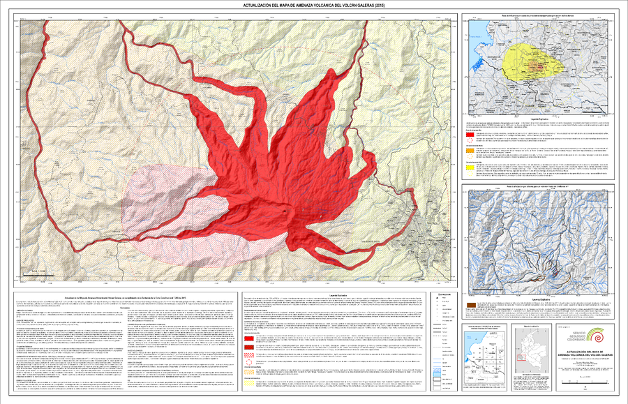
Actualización del Mapa de Amenaza Volcánica del Volcán Galeras (2015)

Update of the Volcanic Hazard Map of the Galeras Volcano (2015)

Galeras, Colombia, 2015

Pocket insert in: Servicio Geológico Colombiano (SGC) Direccion de Geoamenazas. (2015). Actualización del Mapa de Amenaza Volcánica del Volcán Galeras - Colombia. En cumplimiento a la Sentencia de la Corte Constitucional T-269 de 2015.


This map was produced by an official agency, but may not be the most recent, most complete, or main operational map. For the current operational hazard map, please consult the proper institutional authorities.


Click on image for full-size map. If link seems broken, try the archived version.

Map Set

Servicio Geológico Colombiano (SGC) Direccion de Geoamenazas. (2015). Actualización del Mapa de Amenaza Volcánica del Volcán Galeras - Colombia. En cumplimiento a la Sentencia de la Corte Constitucional T-269 de 2015.
http://recordcenter.sgc.gov.co/B22/MapaAmenazaGaleras2015/Documento/Memorias/Memoria_Actualizacion_Mapa_AmenazaVolcanica_VGaleras.pdf

Other Maps In Set:

Map Data

Map ID807
Hazard Process(es)Ballistics; Earthquakes; Gas; Lahars; Lava flows; PDCs; Shockwaves; Tephra fall
Hazard Zone PresentationHazard level- and process-focused: Hazards are both combined by hazard level and separated by hazard process type on a main map and series of insets
Temporal ScaleBackground, or long-term, map
Spatial ScaleVolcano and surrounding area
Publication FormatPoster-style map insert in hazard assessment
Zonation Method(s)Geologic history; Probabilistic modeling; Scenario modeling
Zonation Model(s)Eject! (Mastin 2001); FLO-2D (O'Brien 1993); FLOW2D or FLOW3D (Sheridan & Macías 1992; Kover 1995); LAHARZ or modified version (such as PFZ) (Iverson et al. 1998; Schilling 1998; Schilling 2014); LavaC (Richardson & Connor 2014); LavaPL (Connor et al. 2012); Tephra2 (Bonadonna et al. 2005; Bonadonna et al. 2010; Connor et al. 2011); Unnamed shockwave model [Córdoba & Del Risco (1998)] (Córdoba & Del Risco 1998)
Scenario(s) ConsideredComposition; Season or weather; Size, VEI, or intensity; Source location or direction; Specific past eruption; Style or type
Hazard Zone Label(s)Estimated value or Hazard Impact Metric; Hazard process name; Qualitative relative probability (e.g. high-medium-low)
Probability Definition(s)Qualitative relative probability (e.g. high-medium-low)
PurposeMultiple: intended for multiple purposes including general hazard awareness, planning, and crisis management
AudienceMultiple audiences (usually the public, civil authorities, and land-use planners)
Language(s)Spanish
Basemap(s)Hillshade
Basemap overlay(s)Street map
DiemsionalityPlanimetric (2D or map) view
Color SchemeRed to Yellow
Go to Global Volcanism Program page for Galeras →