← Back to Search Results

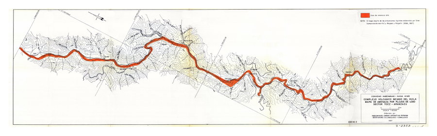
Complejo Volcanico Nevado del Huila Mapa de Amenaza por Flujos de Lodo Sector Toez - Aranzazu

Nevado del Huila Volcanic Complex Mudflow Hazard Map Sector Toez - Aranzazu

Nevado del Huila, Colombia, 1996

Anexo 2 in: Instituto Colombiano de Geología y Minería (INGEOMINAS). (1996). Evaluación de Amenaza y Vigilancia Volcánica del Complejo Volcánico Nevado del Huila. Popayan.


This map was produced by an official agency, but is NOT the most recent, most complete, or main operational map. For the current operational hazard map, please consult the proper institutional authorities.


Click on image for full-size map. If link seems broken, try the archived version.

Map Set

Instituto Colombiano de Geología y Minería (INGEOMINAS). (1996). Evaluación de Amenaza y Vigilancia Volcánica del Complejo Volcánico Nevado del Huila. Popayan.
https://www2.sgc.gov.co/Style%20Library/themes/Intranet/images/volcanes/Informe_mapa_amenaza_VNH_PUBLICAR.pdf

Other Maps In Set:

Map Data

Map ID811
Hazard Process(es)Lahars
Hazard Zone PresentationSingle hazard: A single hazard process is represented on a main map panel
Temporal ScaleBackground, or long-term, map
Spatial ScalePart of volcano (flank or drainage)
Publication FormatPoster-style map insert in hazard assessment
Zonation Method(s)Scenario modeling
Zonation Model(s)Unknown flow model (Unknown reference)
Scenario(s) ConsideredNo scenarios were discernable from the map
Hazard Zone Label(s)Qualitative relative probability (e.g. high-medium-low)
Probability Definition(s)Qualitative relative probability (e.g. high-medium-low)
PurposeMultiple: intended for multiple purposes including general hazard awareness, planning, and crisis management
AudienceMultiple audiences (usually the public, civil authorities, and land-use planners)
Language(s)Spanish
Basemap(s)Contour lines
Basemap overlay(s)
DiemsionalityPlanimetric (2D or map) view
Color SchemeSingle color
Go to Global Volcanism Program page for Nevado del Huila →