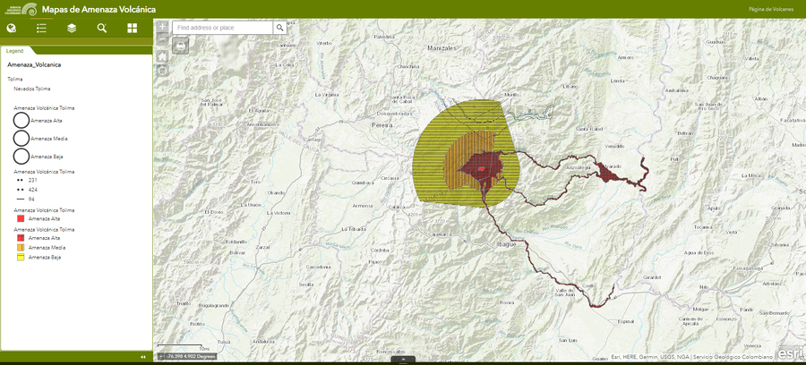
← Back to Search Results

Amenaza Tolima

Tolima Hazards

Nevado del Tolima, Colombia, Year unknown

Servicio Geológico Colombiano (SGC). Amenaza Tolima.


This map was produced by an official agency, but may not be the most recent, most complete, or main operational map. For the current operational hazard map, please consult the proper institutional authorities.


Click on image for full-size map.

Map Data

Map ID817
Hazard Process(es)Ballistics; Lahars; Lava flows; PDCs; Tephra fall
Hazard Zone PresentationHazard level-focused: All or most hazards are combined by hazard level on a main map panel
Temporal ScaleBackground, or long-term, map
Spatial ScaleUser selectable
Publication FormatInteractive web-based map
Zonation Method(s)Derived/simplified from another map
Zonation Model(s)
Scenario(s) ConsideredDuration or timing; Season or weather; Size, VEI, or intensity; Source location or direction; Style or type
Hazard Zone Label(s)Qualitative relative probability (e.g. high-medium-low)
Probability Definition(s)Qualitative relative probability (e.g. high-medium-low)
PurposeMultiple: intended for multiple purposes including general hazard awareness, planning, and crisis management
AudienceMultiple audiences (usually the public, civil authorities, and land-use planners)
Language(s)Spanish
Basemap(s)User selectable
Basemap overlay(s)Street map
DiemsionalityPlanimetric (2D or map) view
Color SchemeRed to Yellow
Go to Global Volcanism Program page for Nevado del Tolima →