← Back to Search Results

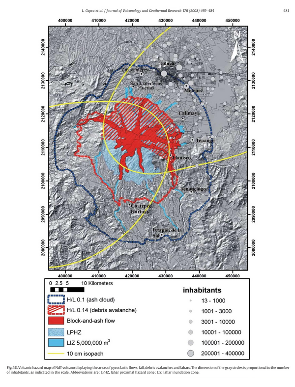
Volcanic hazard map of NdT volcano displaying the areas of pyroclastic flows, fall, debris avalanches and lahars

Nevado de Toluca, Mexico, 2008

Figure 13 in: Capra, L., Norini, G., Groppelli, G., Macías, J.L., & Arce, J.L. (2008). Volcanic hazard zonation of the Nevado de Toluca volcano, México. Journal of Volcanology and Geothermal Research, 176(4), p. 469-484. https://doi.org/10.1016/j.jvolgeores.2008.04.016


This hazard map is the result of scientific research and was published in academic literature. It is presented here to serve as an example of the map type or the map-making methodology. It is NOT the official, operational map. For the current operational hazard map, please consult the proper institutional authorities.


Click on thumbnail for full-size map. We do not have copyright permission to display the full-size image. If you are the copyright holder and wish to provide copyright, please contact us at admin@volcanichazardmaps.org.

Map Set

Capra, L., Norini, G., Groppelli, G., Macías, J.L., & Arce, J.L. (2008). Volcanic hazard zonation of the Nevado de Toluca volcano, México. Journal of Volcanology and Geothermal Research, 176(4), p. 469-484. https://doi.org/10.1016/j.jvolgeores.2008.04.016
https://doi.org/10.1016/j.jvolgeores.2008.04.016

Other Maps In Set:

Map Data

Map ID979
Hazard Process(es)Ash-cloud surges; Debris avalanches; Lahars; PDCs; Tephra fall
Hazard Zone PresentationHazard process-focused: Most hazard processes are separated by hazard process type on a main map panel
Temporal ScaleBackground, or long-term, map
Spatial ScaleVolcano and surrounding area
Publication FormatFigure in a journal article
Zonation Method(s)Scenario modeling
Zonation Model(s)Energy cone or line (Heim 1932; Sheridan 1979; Sheridan & Malin 1983); FLOW2D or FLOW3D (Sheridan & Macías 1992; Kover 1995); HAZMAP (Macedonio et al. 2005); LAHARZ or modified version (such as PFZ) (Iverson et al. 1998; Schilling 1998; Schilling 2014); TITAN2D (Pitman et al. 2003; Patra et al. 2005)
Scenario(s) ConsideredSeason or weather; Size, VEI, or intensity; Specific past eruption
Hazard Zone Label(s)Estimated value or Hazard Impact Metric; Scenario name
Probability Definition(s)No probability definition was discernable from the map
PurposeScientific interest: Intended for scientific research and general scientific interest; usually published in academic journals
AudienceScientists (usually in scientific publication)
Language(s)English
Basemap(s)Hillshade
Basemap overlay(s)Population map; Street map
DiemsionalityPlanimetric (2D or map) view
Color SchemeCategorical/Qualitative
Go to Global Volcanism Program page for Nevado de Toluca →