
Advanced Search for Maps
Showing 1-10 of 20
Official, Insert/poster-size map with accompanying report
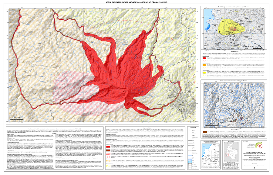
Actualización del Mapa de Amenaza Volcánica del Volcán Galeras (2015)
(Update of the Volcanic Hazard Map of the Galeras Volcano (2015))
Pocket insert in: Servicio Geológico Colombiano (SGC) Direccion de Geoamenazas. (2015). Actualización del Mapa de Amenaza Volcánica del Volcán Galeras - Colombia. En cumplimiento a la Sentencia de la Corte Constitucional T-269 de 2015.
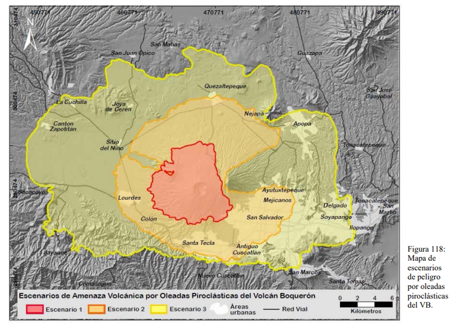
Figure in a thesis or dissertation
Escenarios de Amenaza por Oleadas Piroclásticas del Volcán Boquerón
(Threat Scenarios due to Pyroclastic Surges from the Boquerón Volcano)
Figure 118 in: Ferrés López, M.D. (2014). Estratigrafía, Geología y Evaluación de Peligros Volcánicos del Complejo Volcánico de San Salvador (El Salvador). Doctoral Thesis, Universidad Autónoma de México, México.
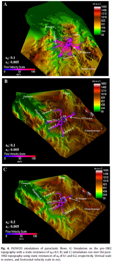
Figure in a journal article
FLOW3D simulations of pyroclastic flows
Figure 4 in: Macías, J. L., Capra, L., Arce, J. L., Espíndola, J. M., García-Palomo, A., & Sheridan, M. F. (2008). Hazard map of El Chichón volcano, Chiapas, México: Constraints posed by eruptive history and computer simulations. Journal of Volcanology and Geothermal Research, 175(4), 444-458. https://doi.org/10.1016/j.jvolgeores.2008.02.023
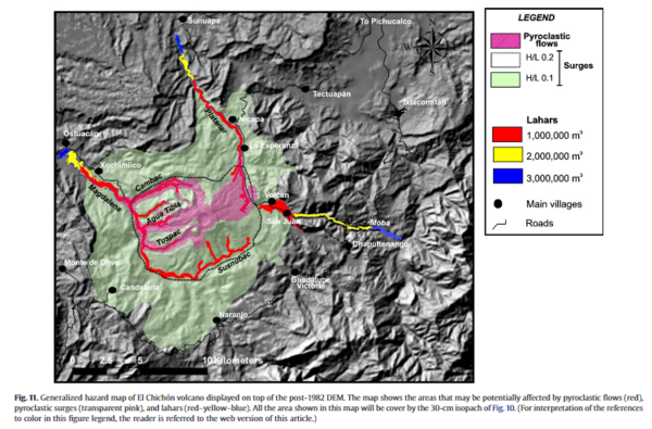
Figure in a journal article
Generalized hazard map of El Chichón volcano displayed on top of the post-1982 DEM
Figure 11 in: Macías, J. L., Capra, L., Arce, J. L., Espíndola, J. M., García-Palomo, A., & Sheridan, M. F. (2008). Hazard map of El Chichón volcano, Chiapas, México: Constraints posed by eruptive history and computer simulations. Journal of Volcanology and Geothermal Research, 175(4), 444-458. https://doi.org/10.1016/j.jvolgeores.2008.02.023
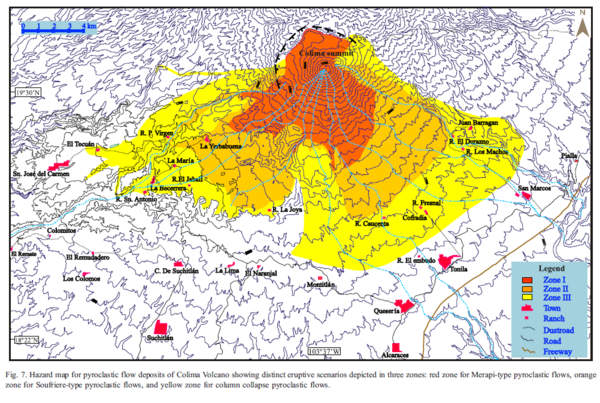
Figure in a journal article
Hazard map for pyroclastic flow deposits of Colima Volcano showing distinct eruptive scenarios depicted in three zones.
Figure 7 in: Saucedo, R., Macías, J.L., Sheridan, M.F., Bursik, M.I., & Komorowski, J.-C. (2005). Modeling of pyroclastic flows of Colima Volcano, Mexico: implications for hazard assessment. Journal of Volcanology and Geothermal Research, 139(1-2), p. 103-115. https://doi.org/10.1016/j.jvolgeores.2004.06.019
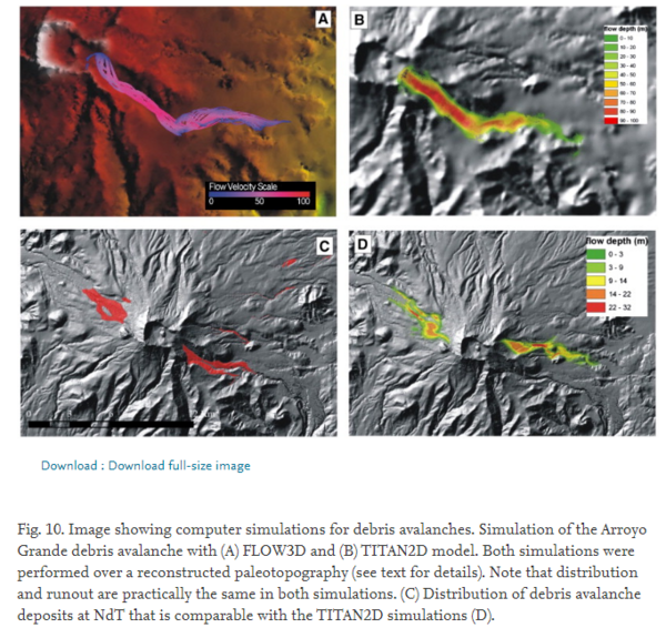
Figure in a journal article
Image showing computer simulations for debris avalanches
Figure 10 in: Capra, L., Norini, G., Groppelli, G., Macías, J.L., & Arce, J.L. (2008). Volcanic hazard zonation of the Nevado de Toluca volcano, México. Journal of Volcanology and Geothermal Research, 176(4), p. 469-484. https://doi.org/10.1016/j.jvolgeores.2008.04.016
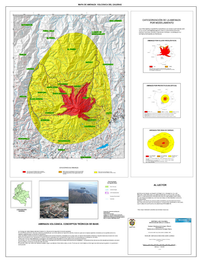
Official, Figure in a journal article
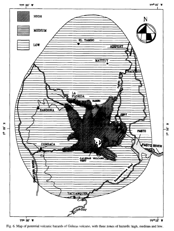
Map of potencial volcanic hazards of Galeras volcano, with three zones of hazards: high, medium and low
Figure 6 in: Artunduaga, A.D.H., & Jiménez, G.P.C. (1997). Third version of the hazard map of Galeras Volcano, Colombia. Journal of Volcanology and Geothermal research, 77(1-4), p. 89-100. https://doi.org/10.1016/S0377-0273(96)00088-1
Official, Insert/poster-size map with accompanying report
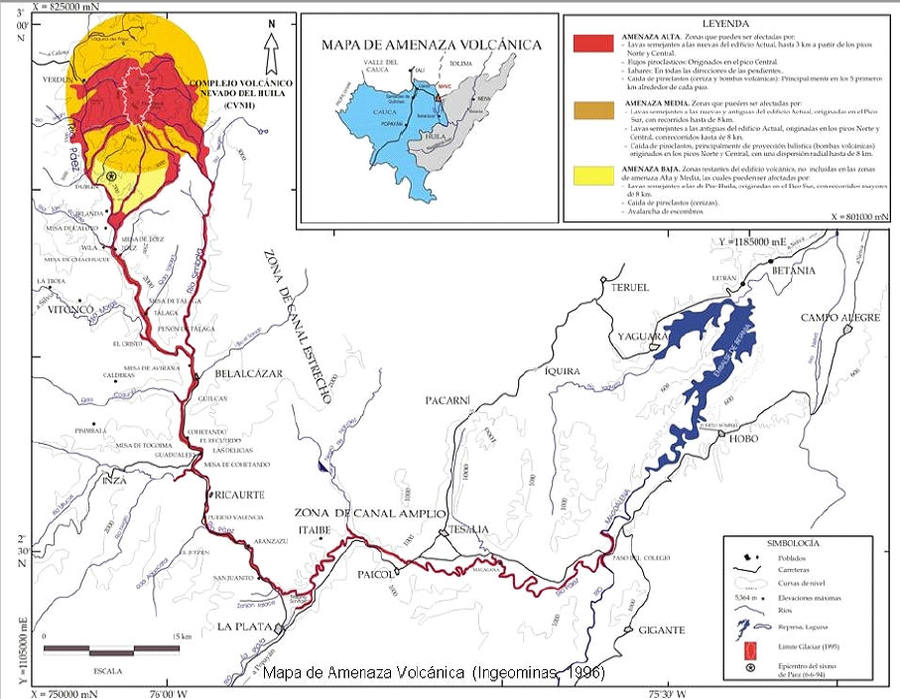
Mapa de Amenaza Volcánica
(Volcanic Hazard Map)
Anexo 1 in: Instituto Colombiano de Geología y Minería (INGEOMINAS). (1996). Evaluación de Amenaza y Vigilancia Volcánica del Complejo Volcánico Nevado del Huila. Popayan.
Official, Map sheet or poster
Mapa de Amenaza Volcánica del Galeras Versión 2007
(Galeras Volcanic Hazard Map Version 2007)
Instituto Colombiano de Geología y Minería (INGEOMINAS). (2007). Mapa de Amenaza Volcánicas de Galeras. Atlas de Amenaza Volcanica Versión 2007.
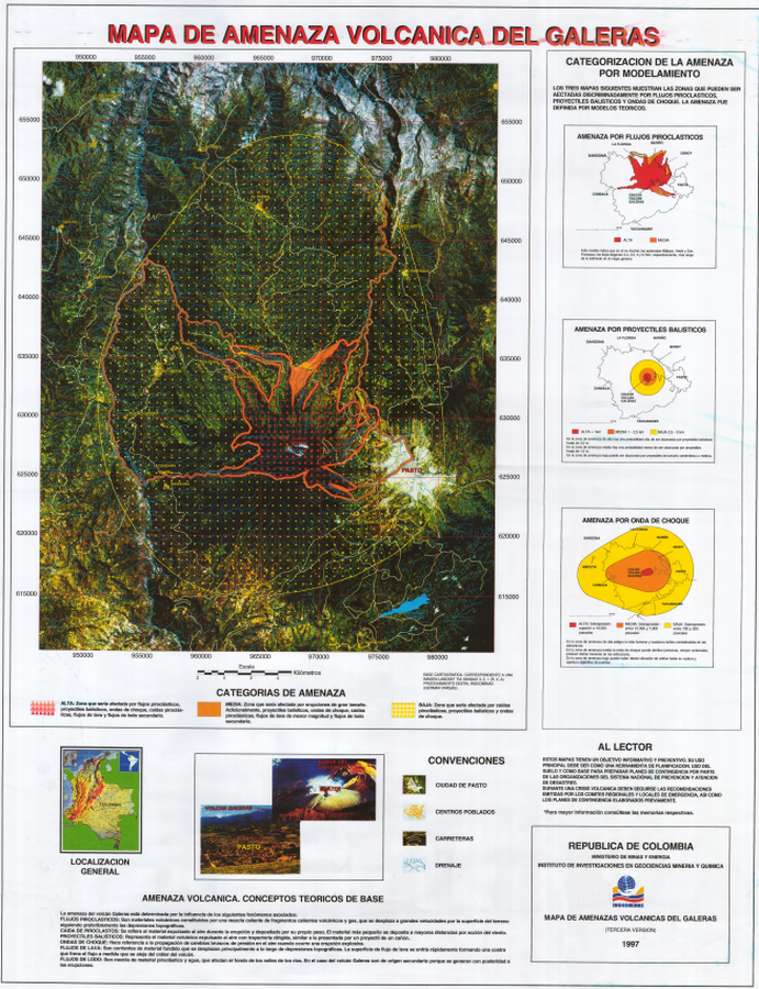
Official, Insert/poster-size map with accompanying report
Mapa de Amenaza Volcánica del Galeras, Tercera Version
(Galeras Volcanic Hazard Map, Third Version)
Pocket insert in: Instituto Colombiano de Geología y Minería (INGEOMINAS). (1997). Mapa de Amenaza Volcánica del Galeras. Tercera versión. Publicación Especial de INGEOMINAS.
Page: 1 2