
Advanced Search for Maps
Showing 1-1 of 1
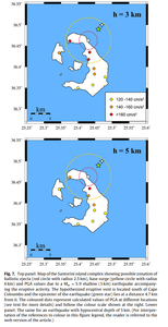
Figure in a journal article
Top panel: Map of the Santorini island complex showing possible zonation of ballistic ejecta (red circle with radius 2.5 km), base surge (yellow circle with radius 6 km) and PGA values due to a Mw =5.9 shallow (3 km) earthquake accompanying the eruptive activity...Lower panel: The same for an earthquake with hypocentral depth of 5 km
Figure 7 in: Konstantinou, K.I. & Yeh, T.Y. (2012). Stress field around the Coloumbo magma chamber, southern Aegean: Its significance for assessing volcanic and seismic hazard in Santorini. Journal of Geodynamics, 54, 13-20. https://doi.org/10.1016/j.jog.2011.09.003