
Advanced Search for Maps
Showing 1-9 of 9
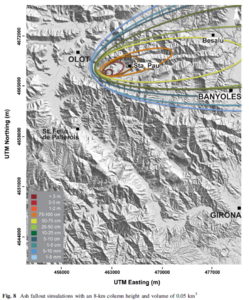
Figure in a journal article
Ash fallout simulations with an 8-km column height and volume of 0.05 km³
Figure 8 in: Bartolini, S., Bolós, X., Martí, J., Pedra, E. R., & Planagumà, L. (2015). Hazard assessment at the quaternary La Garrotxa volcanic field (NE Iberia). Natural Hazards, 78(2), 1349-1367. https://doi.org/10.1007/s11069-015-1774-y
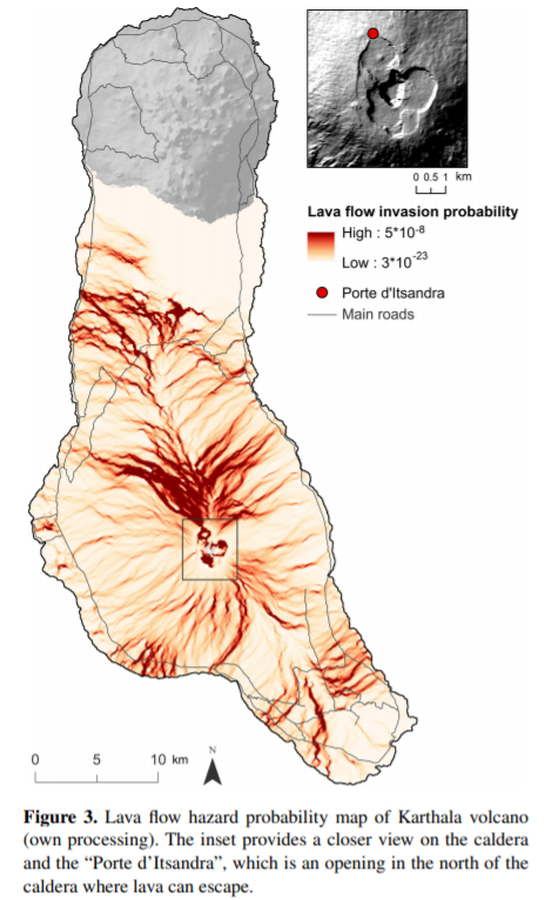
Figure in a journal article
Lava flow hazard probability map of Karthala volcano
Figure 3 in: Mossoux, S., Kervyn, M., & Canters, F. (2019). Assessing the impact of road segment obstruction on accessibility of critical services in case of a hazard. Natural Hazards & Earth System Sciences, 19(6). https://doi.org/10.5194/nhess-19-1251-2019
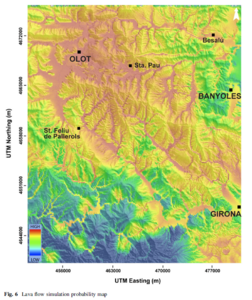
Figure in a journal article
Lava flow simulation probability map
Figure 6 in: Bartolini, S., Bolós, X., Martí, J., Pedra, E. R., & Planagumà, L. (2015). Hazard assessment at the quaternary La Garrotxa volcanic field (NE Iberia). Natural Hazards, 78(2), 1349-1367. https://doi.org/10.1007/s11069-015-1774-y
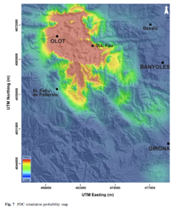
Figure in a journal article
PDC simulation probability map
Figure 7 in: Bartolini, S., Bolós, X., Martí, J., Pedra, E. R., & Planagumà, L. (2015). Hazard assessment at the quaternary La Garrotxa volcanic field (NE Iberia). Natural Hazards, 78(2), 1349-1367. https://doi.org/10.1007/s11069-015-1774-y
Official, Figure in hazard assessment
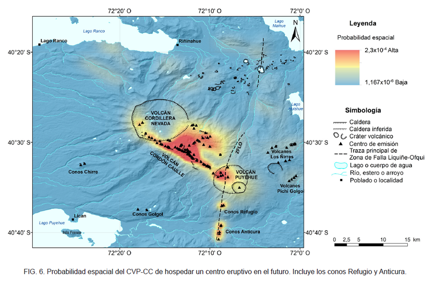
Probabilidad espacial del CVP-CC de hospedar un centro eruptivo en el futuro
(Spatial probability of the CVP-CC of hosting an eruptive center in the future)
Figure 6 in: Toloza, V., Jorquera, C., Mella, M., Gho, R. (2020). Peligros del Complejo Volcánico Puyehue-Cordón Caulle, regiones de Los Ríos y Los Lagos. Servicio Nacional de Geología y Minería, Carta Geológica de Chile, Serie Geología Ambiental 36, 63 p., 1 mapa escala 1:75.000. Santiago.
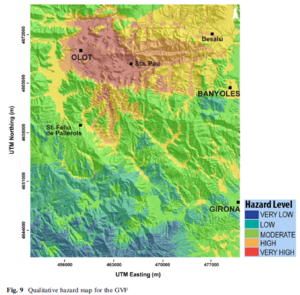
Figure in a journal article
Qualitative hazard map for the GVF
Figure 9 in: Bartolini, S., Bolós, X., Martí, J., Pedra, E. R., & Planagumà, L. (2015). Hazard assessment at the quaternary La Garrotxa volcanic field (NE Iberia). Natural Hazards, 78(2), 1349-1367. https://doi.org/10.1007/s11069-015-1774-y
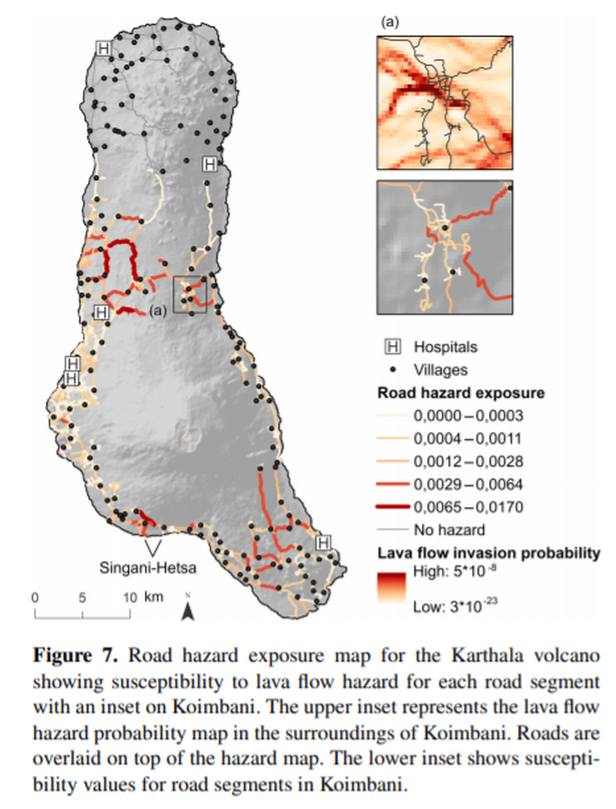
Figure in a journal article
Road hazard exposure map for the Karthala volcano
Figure 7 in: Mossoux, S., Kervyn, M., & Canters, F. (2019). Assessing the impact of road segment obstruction on accessibility of critical services in case of a hazard. Natural Hazards & Earth System Sciences, 19(6). https://doi.org/10.5194/nhess-19-1251-2019
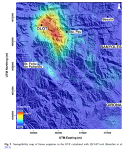
Figure in a journal article
Susceptibility map of future eruptions in the GVF calculated with QVAST tool
Figure 5 in: Bartolini, S., Bolós, X., Martí, J., Pedra, E. R., & Planagumà, L. (2015). Hazard assessment at the quaternary La Garrotxa volcanic field (NE Iberia). Natural Hazards, 78(2), 1349-1367. https://doi.org/10.1007/s11069-015-1774-y
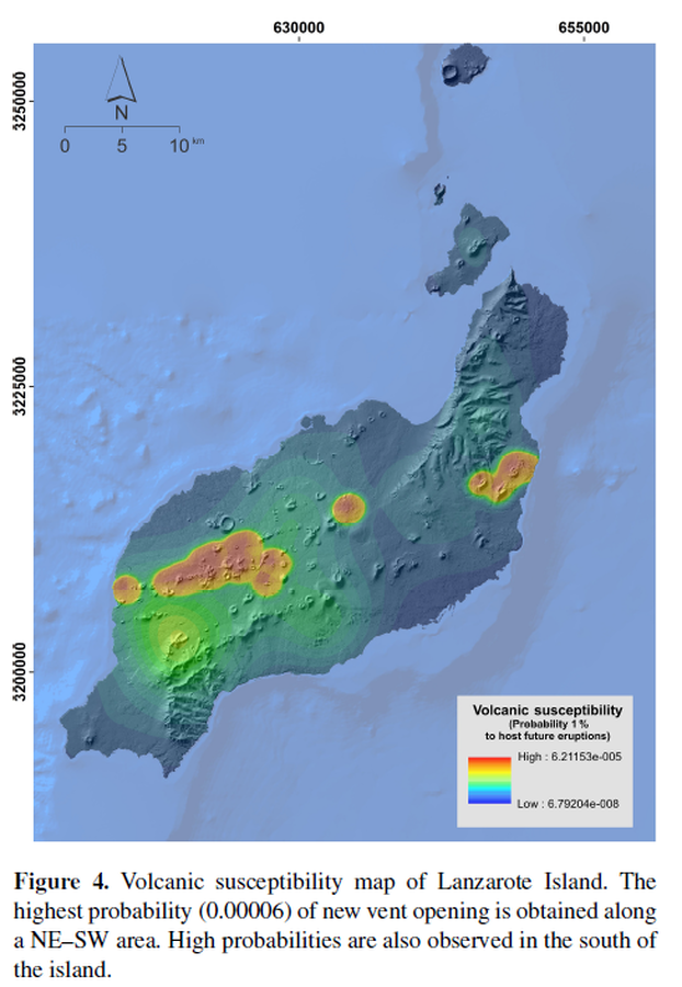
Figure in a journal article
Susceptibility map of Lanzarote Island
Figure 4 in: Becerril, L., Martí, J., Bartolini, S., & Geyer, A. (2017). Assessing qualitative long-term volcanic hazards at Lanzarote Island (Canary Islands). Natural Hazards and Earth System Sciences, 17(7), 1145-1157. https://doi.org/10.5194/nhess-17-1145-2017