
Advanced Search for Maps
Showing 1-10 of 11
Official, Insert/poster-size map with accompanying report
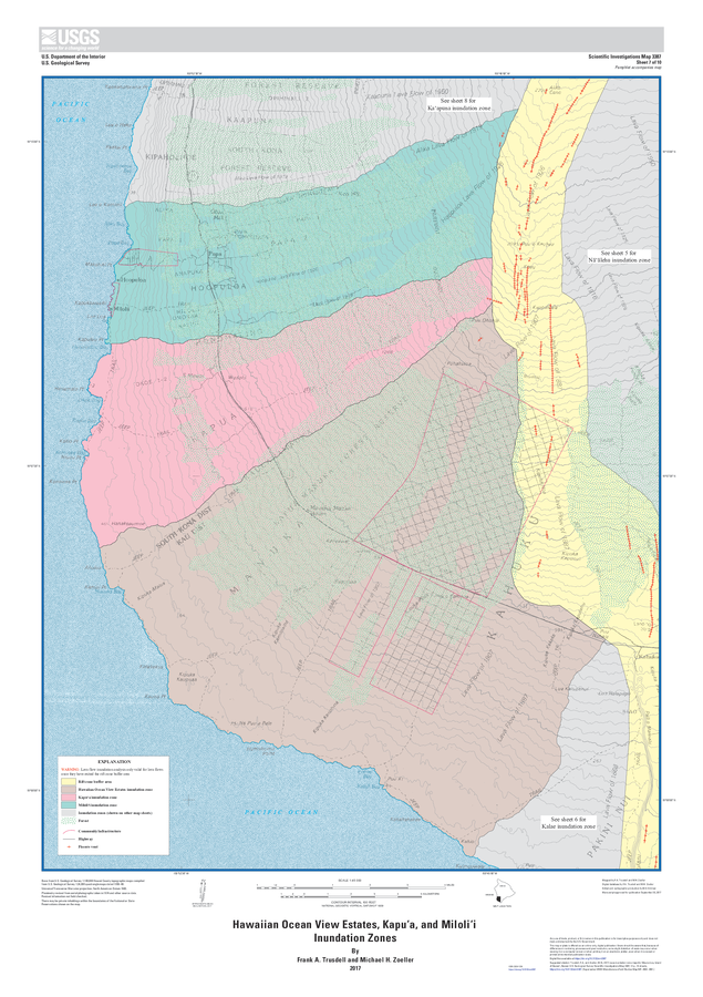
Hawaiian Ocean View Estates, Kapuʻa, and Miloliʻi Inundation Zones
Sheet 7 in: Trusdell, F.A. & Zoeller, M.H. (2017). Lava inundation zone maps for Mauna Loa, Island of Hawaiʻi, Hawaii. U.S. Geological Survey, Scientific Investigations Map 3387, 12 p., 10 sheets. https://doi.org/10.3133/sim3387
Official, Insert/poster-size map with accompanying report
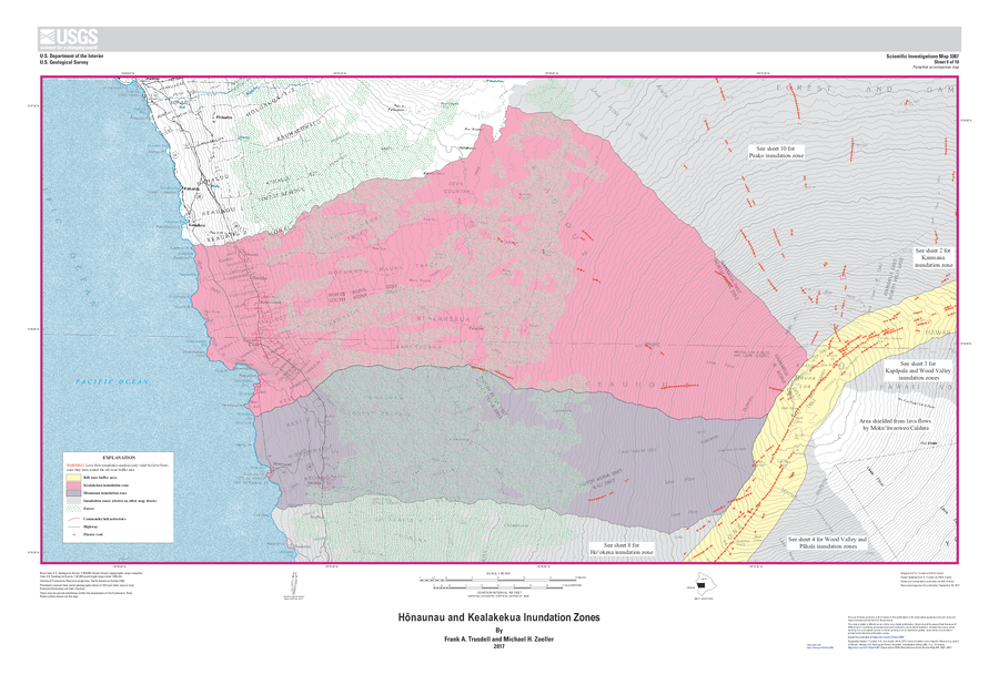
Hōnaunau and Kealakekua Inundation Zones
Sheet 9 in: Trusdell, F.A. & Zoeller, M.H. (2017). Lava inundation zone maps for Mauna Loa, Island of Hawaiʻi, Hawaii. U.S. Geological Survey, Scientific Investigations Map 3387, 12 p., 10 sheets. https://doi.org/10.3133/sim3387
Official, Insert/poster-size map with accompanying report
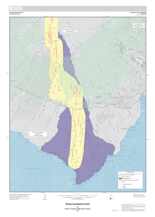
Kalae Inundation Zone
Sheet 6 in: Trusdell, F.A. & Zoeller, M.H. (2017). Lava inundation zone maps for Mauna Loa, Island of Hawaiʻi, Hawaii. U.S. Geological Survey, Scientific Investigations Map 3387, 12 p., 10 sheets. https://doi.org/10.3133/sim3387
Official, Insert/poster-size map with accompanying report
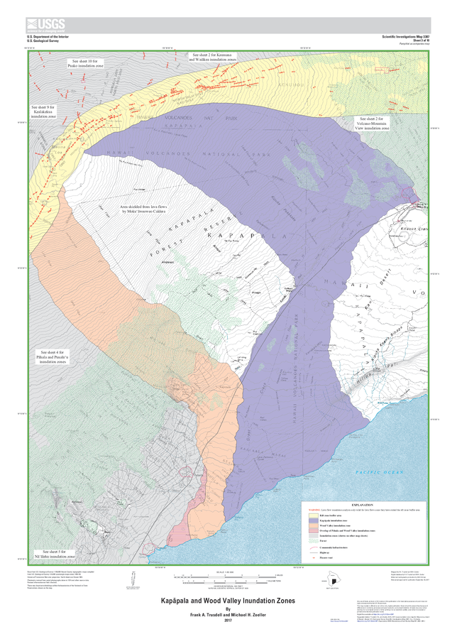
Kapāpala and Wood Valley Inundation Zones
Sheet 3 in: Trusdell, F.A. & Zoeller, M.H. (2017). Lava inundation zone maps for Mauna Loa, Island of Hawaiʻi, Hawaii. U.S. Geological Survey, Scientific Investigations Map 3387, 12 p., 10 sheets. https://doi.org/10.3133/sim3387
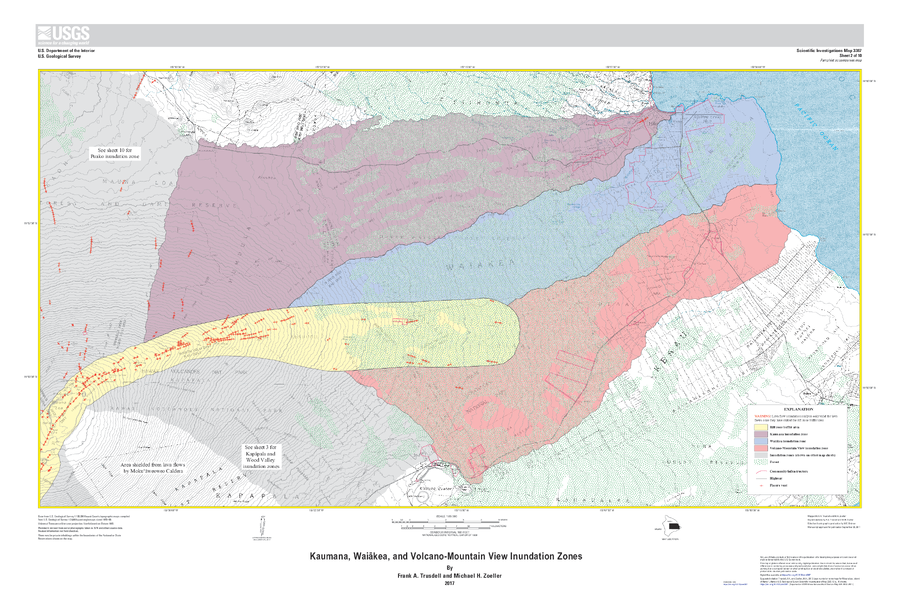
Official, Insert/poster-size map with accompanying report
Kaumana, Waiākea, and Volcano-Mountain View Inundation Zones
Sheet 2 in: Trusdell, F.A. & Zoeller, M.H. (2017). Lava inundation zone maps for Mauna Loa, Island of Hawaiʻi, Hawaii. U.S. Geological Survey, Scientific Investigations Map 3387, 12 p., 10 sheets. https://doi.org/10.3133/sim3387
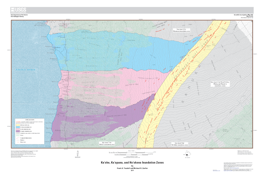
Official, Insert/poster-size map with accompanying report
Kaʻohe, Kaʻapuna, and Hoʻokena Inundation Zones
Sheet 8 in: Trusdell, F.A. & Zoeller, M.H. (2017). Lava inundation zone maps for Mauna Loa, Island of Hawaiʻi, Hawaii. U.S. Geological Survey, Scientific Investigations Map 3387, 12 p., 10 sheets. https://doi.org/10.3133/sim3387
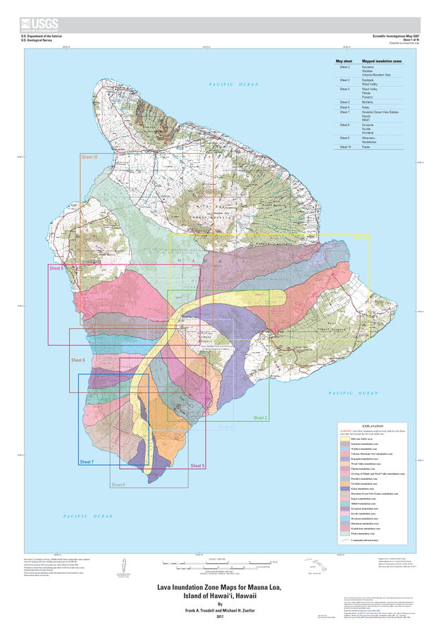
Official, Insert/poster-size map with accompanying report
Lava Inundation Zone Maps for Mauna Loa, Island of Hawaiʻi, Hawaii
Sheet 1 in: Trusdell, F.A. & Zoeller, M.H. (2017). Lava inundation zone maps for Mauna Loa, Island of Hawaiʻi, Hawaii. U.S. Geological Survey, Scientific Investigations Map 3387, 12 p., 10 sheets. https://doi.org/10.3133/sim3387
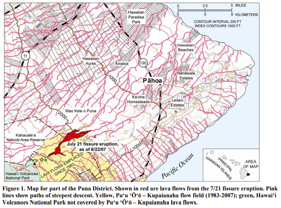
Official, Figure in hazard assessment
Map for part of the Puna District
Figure 1 in: Kauahikaua, J. (2007). Lava flow hazard assessment, as of August 2007, for Kīlauea east rift zone eruptions, Hawai‘i Island. U.S. Geological Survey Open-File Report 2007-1264, 9 p.
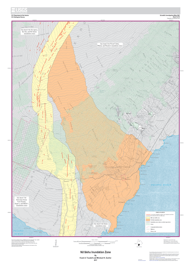
Official, Insert/poster-size map with accompanying report
Nāʻālehu Inundation Zone
Sheet 5 in: Trusdell, F.A. & Zoeller, M.H. (2017). Lava inundation zone maps for Mauna Loa, Island of Hawaiʻi, Hawaii. U.S. Geological Survey, Scientific Investigations Map 3387, 12 p., 10 sheets. https://doi.org/10.3133/sim3387
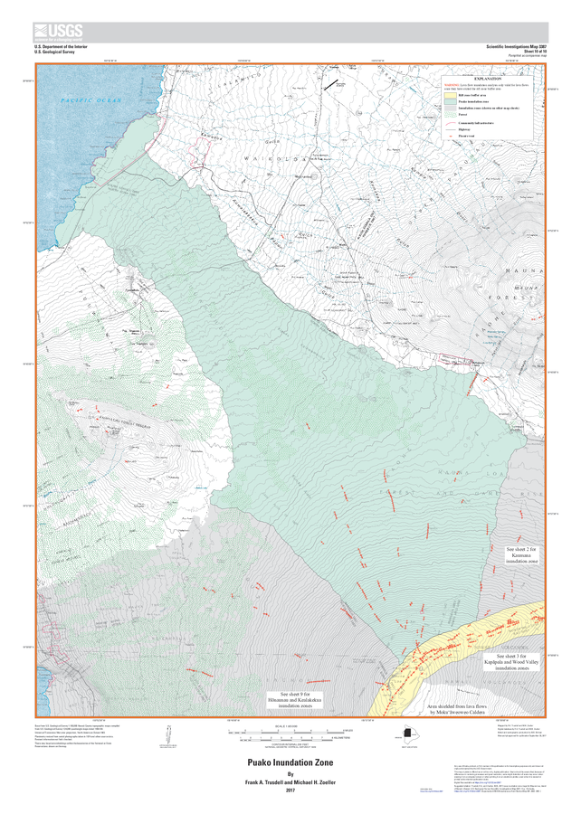
Official, Insert/poster-size map with accompanying report
Puako Inundation Zone
Sheet 10 in: Trusdell, F.A. & Zoeller, M.H. (2017). Lava inundation zone maps for Mauna Loa, Island of Hawaiʻi, Hawaii. U.S. Geological Survey, Scientific Investigations Map 3387, 12 p., 10 sheets. https://doi.org/10.3133/sim3387
Page: 1 2