
Advanced Search for Maps
Showing 1121-1130 of 2217
Official, Insert/poster-size map with accompanying report
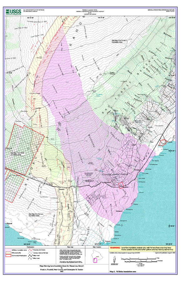
Maps Showing Lava Inundation Zones for Mauna Loa, Hawai'i - Map 5. Na'alehu inundation zone
Sheet 5 in: Trusdell, F.A., Graves, P., & Tincher, C.R. (2002). Map Showing Lava Inundation Zones for Mauna Loa, Hawai‘i. U.S. Geological Survey, Miscellaneous Field Studies Map MF-2401. 10 Map Sheets (each 22 x 34 inches); Pamphlet (14 p.) scale 1:70000. https://doi.org/10.3133/mf2401
Official, Insert/poster-size map with accompanying report
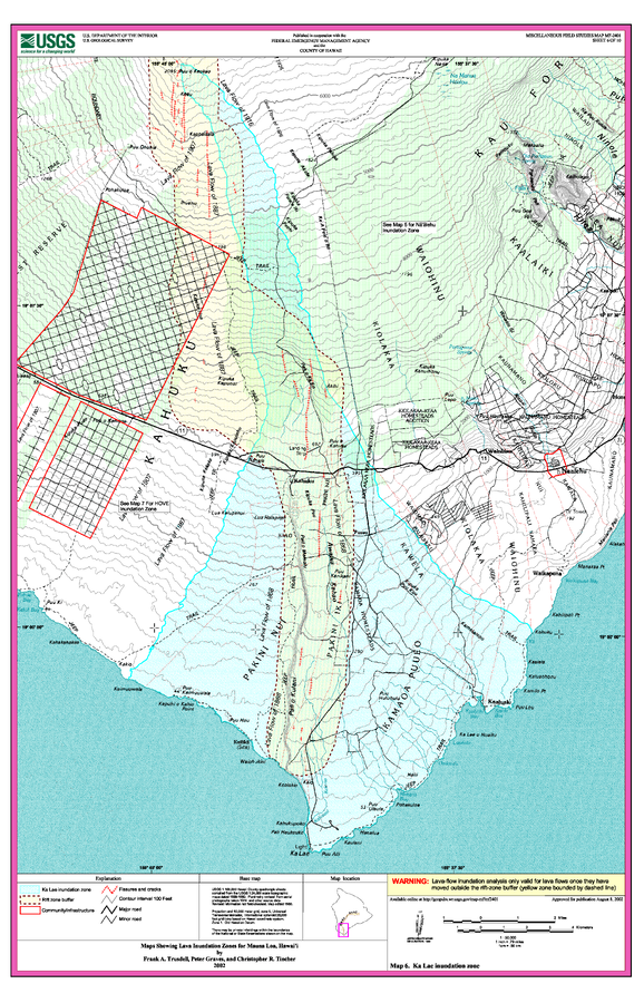
Maps Showing Lava Inundation Zones for Mauna Loa, Hawai'i - Map 6. Ka Lae inundation zone
Sheet 6 in: Trusdell, F.A., Graves, P., & Tincher, C.R. (2002). Map Showing Lava Inundation Zones for Mauna Loa, Hawai‘i. U.S. Geological Survey, Miscellaneous Field Studies Map MF-2401. 10 Map Sheets (each 22 x 34 inches); Pamphlet (14 p.) scale 1:70000. https://doi.org/10.3133/mf2401

Official, Insert/poster-size map with accompanying report
Maps Showing Lava Inundation Zones for Mauna Loa, Hawai'i - Map 7. HOVE, Kapu'a, and Miloli'i inundation zones
Sheet 7 in: Trusdell, F.A., Graves, P., & Tincher, C.R. (2002). Map Showing Lava Inundation Zones for Mauna Loa, Hawai‘i. U.S. Geological Survey, Miscellaneous Field Studies Map MF-2401. 10 Map Sheets (each 22 x 34 inches); Pamphlet (14 p.) scale 1:70000. https://doi.org/10.3133/mf2401

Official, Insert/poster-size map with accompanying report
Maps Showing Lava Inundation Zones for Mauna Loa, Hawai'i - Map 8. Ho'okena, Ka'ohe, and Ka'apuna inundation zones
Sheet 8 in: Trusdell, F.A., Graves, P., & Tincher, C.R. (2002). Map Showing Lava Inundation Zones for Mauna Loa, Hawai‘i. U.S. Geological Survey, Miscellaneous Field Studies Map MF-2401. 10 Map Sheets (each 22 x 34 inches); Pamphlet (14 p.) scale 1:70000. https://doi.org/10.3133/mf2401
Official, Insert/poster-size map with accompanying report
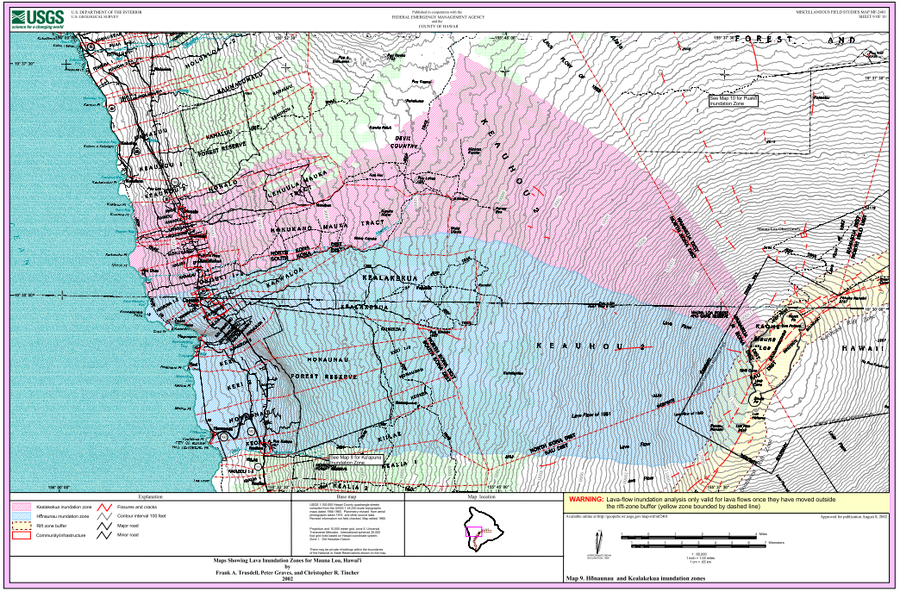
Maps Showing Lava Inundation Zones for Mauna Loa, Hawai'i - Map 9. Honaunau and Kealakekua inundation zones
Sheet 9 in: Trusdell, F.A., Graves, P., & Tincher, C.R. (2002). Map Showing Lava Inundation Zones for Mauna Loa, Hawai‘i. U.S. Geological Survey, Miscellaneous Field Studies Map MF-2401. 10 Map Sheets (each 22 x 34 inches); Pamphlet (14 p.) scale 1:70000. https://doi.org/10.3133/mf2401
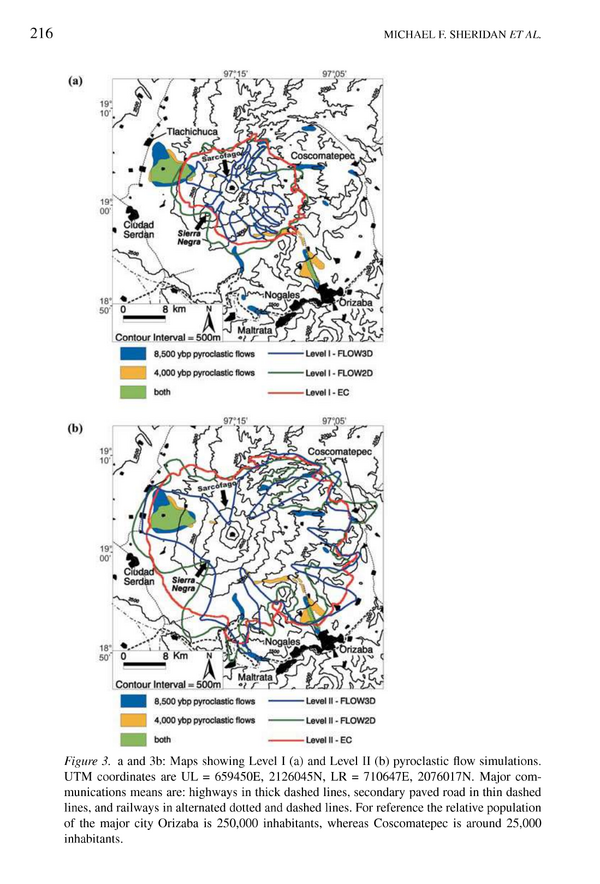
Figure in a journal article
Maps showing Level I and Level II pyroclastic flow simulations
Figure 3 in: Sheridan, M. F., Hubbard, B., Carrasco-Núñez, G., & Siebe, C. (2004). Pyroclastic flow hazard at Volcán Citlaltépetl. Natural Hazards, 33(2), p. 209-221. https://doi.org/10.1023/B:NHAZ.0000037028.89829.d1
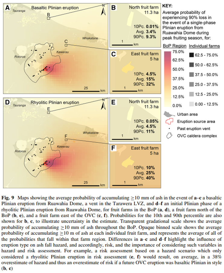
Figure in a journal article
Maps showing the average probability of accumulating ≥10 mm of ash in the event of a–c a basaltic Plinian eruption from Ruawahia Dome, a vent in the Tarawera LVZ, and d–f an initial Plinian phase of a rhyolitic Plinian eruption from Ruawahia Dome, for fruit farms in the BoP
Figure 9 in: Thompson, M. A., Lindsay, J. M., Wilson, T. M., Biass, S., & Sandri, L. (2017). Quantifying risk to agriculture from volcanic ashfall: a case study from the Bay of Plenty, New Zealand. Natural Hazards, 86(1), 31-56. https://doi.org/10.1007/s11069-016-2672-7
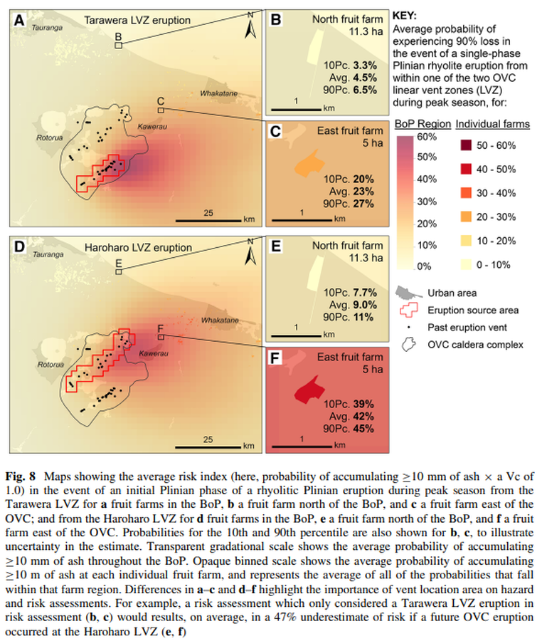
Figure in a journal article
Maps showing the average risk index (here, probability of accumulating ≥10 mm of ash × a Vc of 1.0) in the event of an initial Plinian phase of a rhyolitic Plinian eruption during peak season from the Tarawera LVZ for a fruit farms in the BoP
Figure 8 in: Thompson, M. A., Lindsay, J. M., Wilson, T. M., Biass, S., & Sandri, L. (2017). Quantifying risk to agriculture from volcanic ashfall: a case study from the Bay of Plenty, New Zealand. Natural Hazards, 86(1), 31-56. https://doi.org/10.1007/s11069-016-2672-7
Official, Figure in hazard assessment
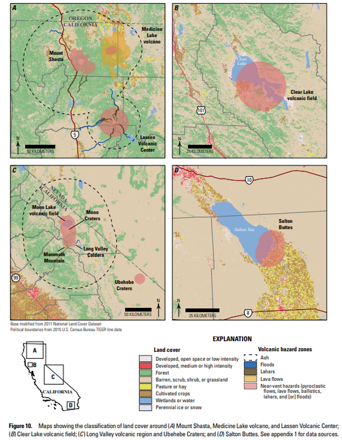
Maps showing the classification of land cover around (A) Mount Shasta, Medicine Lake volcano, and Lassen Volcanic Center; (B) Clear Lake volcanic field; (C ) Long Valley volcanic region and Ubehebe Craters; and (D) Salton Buttes
Figure 10 in: Mangan, M., Ball, J., Wood, N., Jones, J.L., Peters, J., Abdollahian, N., Dinitz, L., Blankenheim, S., Fenton, J., & Pridmore, C. (2019). California’s exposure to volcanic hazards. U.S. Geological Survey Scientific Investigations Report 2018–5159, v. 1.1, 49 p. https://doi.org/10.3133/sir20185159
Official, Insert/poster-size map with accompanying report
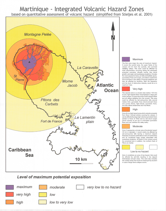
Martinique - Integrated Volcanic Hazard Zones based on quantitative assessment of volcanic hazard (simplified from Stieltjes et al. 2001)
Pocket insert in: Boudon, G., Le Friant, A., Villemant, B., & Viode, J.-P. (2005). Martinique. In: Lindsay, J.M., Shepherd, J.B., Robertson, R.E.A., & Ali, S. (Eds) Volcanic hazard atlas of the Lesser Antilles. Seismic Research Unit, The University of the West Indies, Trinidad and Tobago, W.I., p. 128-146. (Simplified from: Stieltjes et al. 2001)