
Advanced Search for Maps
Showing 301-310 of 2217
Official, Map in an information statement
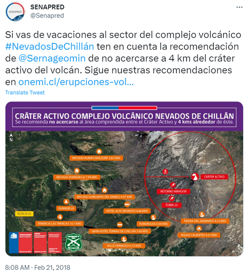
Cráter Activo Complejo Volcánico Nevados de Chillán
(Nevados de Chillán Active Crater Complex )
Servicio Nacional de Geología y Minería (SERNAGEOMIN) & Oficina Nacional de Emergencia del Ministerio del Interior y Seguridad Pública (ONEMI). (2018). Cráter Activo Complejo Volcánico Nevados de Chillán. Twitter. https://twitter.com/Senapred/status/966343871520215040
Official, Interactive web-based map
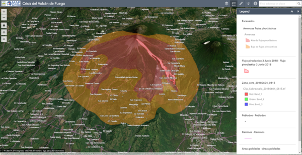
Crisis del Volcán de Fuego
(Fuego Volcano Crisis)
Instituto Nacional de Sismología, Vulcanologia, Meteorologia e Hidrología (INSIVUMEH), Map Action, Volcano Disaster Assistance Program (VDAP), U.S. Geological Survey (USGS), University of Edinburgh & Michigan Technological University. (2018). Crisis del Volcan Fuego.
Official, Map in an information statement
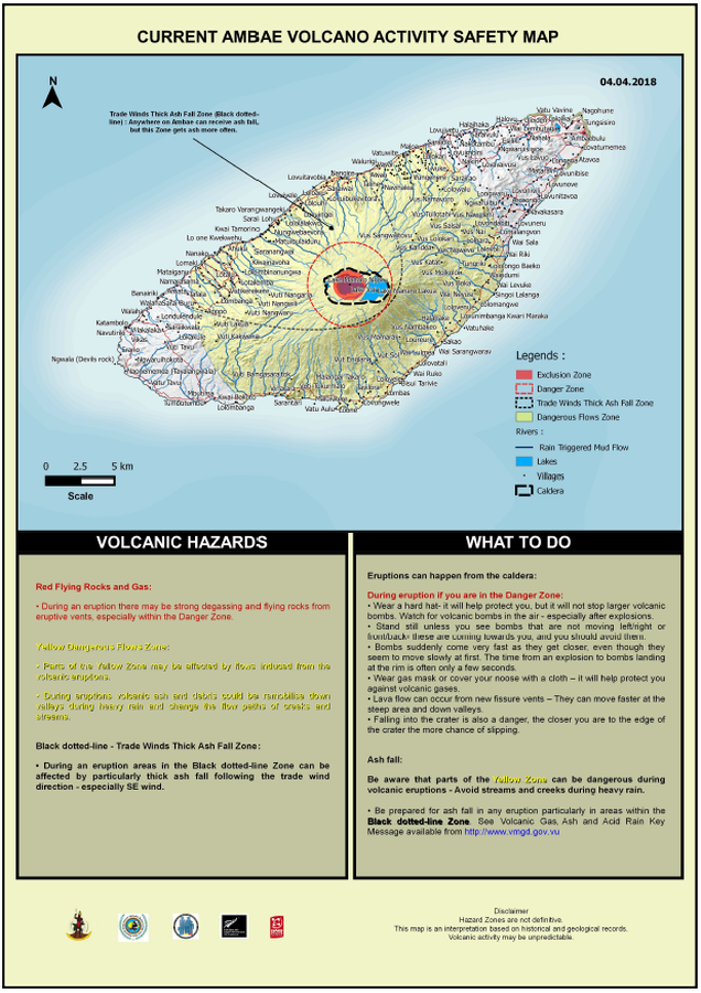
Current Ambae Volcano Activity Safety Map
Vanuatu Meteorology & Geo-Hazards Department. (2018). Current Ambae Volcano Activity Safety Map 04.04.2018. Government of Vanuatu, Vanuatu Meteorology & Geo-Hazards Department, Vanuatu National Disaster Risk Management Office, New Zealand Foreign Affairs & Trade Aid Programme, GNS Science.
Official, Map in an information statement
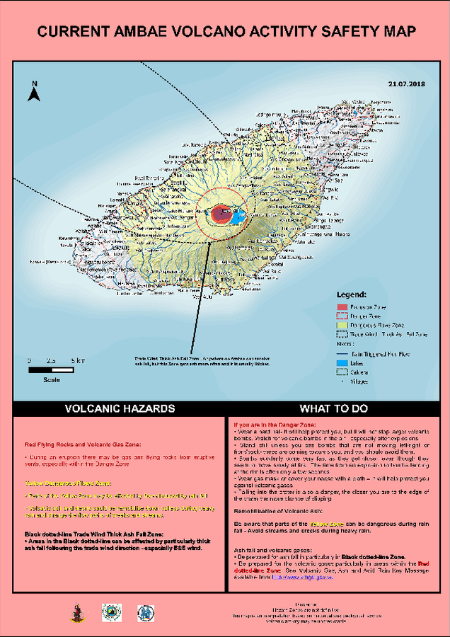
Current Ambae Volcano Activity Safety Map
Vanuatu Meteorology & Geo-Hazards Department. (2018). Current Ambae Volcano Activity Safety Map 21.07.2018. Government of Vanuatu, Vanuatu Meteorology & Geo-Hazards Department, Vanuatu National Disaster Risk Management Office, New Zealand Foreign Affairs & Trade Aid Programme, GNS Science.
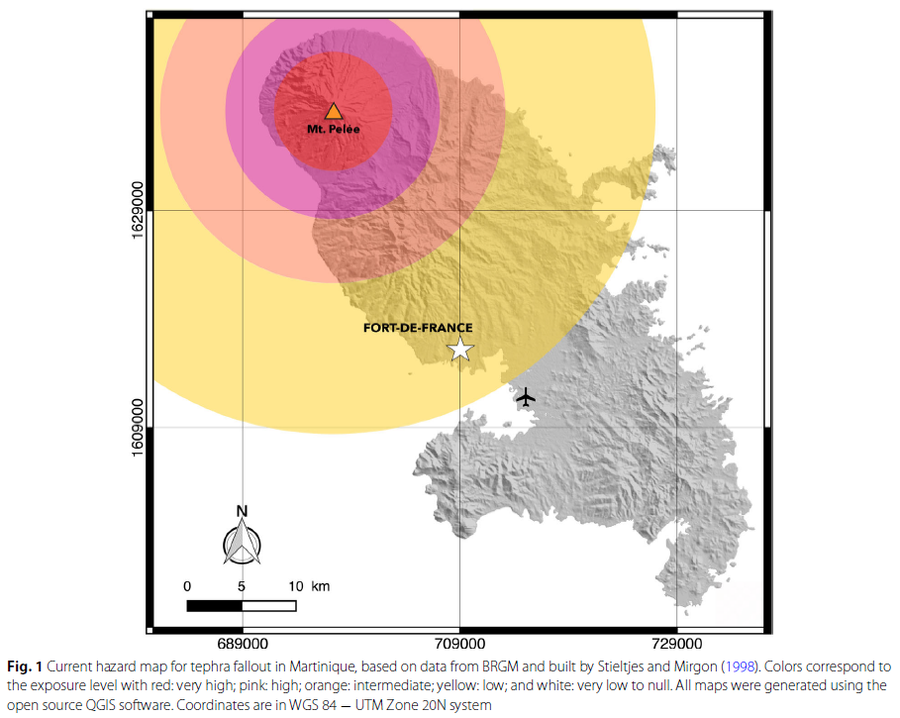
Figure in a journal article
Current hazard map for tephra fallout in Martinique
Figure 1 in: Michaud-Dubuy, A., Carazzo, G., & Kaminski, E. (2021). Volcanic hazard assessment for tephra fallout in Martinique. Journal of Applied Volcanology, 10(1), 1-20. https://doi.org/10.1186/s13617-021-00106-7. (Modified from: Stieltjes & Mirgon 1998)
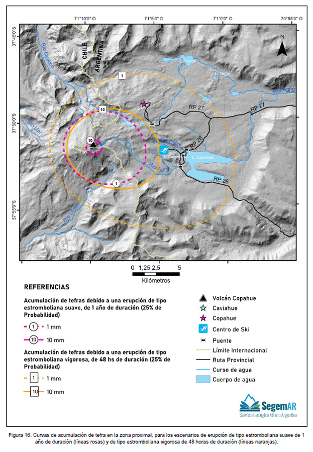
Official, Figure in hazard assessment
Curvas de acumulación de tefra en la zona proximal, para los escenarios de erupción de tipo estromboliana suave de 1 año de duración (líneas rosas) y de tipo estromboliana vigorosa de 48 horas de duración (líneas naranjas)
(Tephra accumulation curves in the proximal zone, for the mild Strombolian type eruption scenarios lasting 1 year (pink lines) and the vigorous Strombolian type erupting for 48 hours (orange lines))
Figure 16 in: Kaufman, J. F., Elissondo, M., Sruoga, P., Yamín, M. G. 2023. Peligrosidad del volcán Copahue. Provincia del Neuquén, República Argentina. Serie de Contribuciones Técnicas Peligrosidad Geológica N° 24. 51 pp. Buenos Aires, Servicio Geológico Minero Argentino (SEGEMAR). Instituto de Geología y Recursos Minerales.
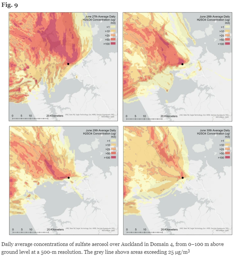
Figure in a journal article
Daily average concentrations of sulfate aerosol over Auckland in Domain 4, from 0–100 m above ground level at a 500-m resolution
Figure 9 in: Brody-Heine, S., Katurji, M., Stewart, C., Wilson, T., Smid, E. R., & Trancoso, R. (2024). Modeling SO2 dispersion from future eruptions in the Auckland Volcanic Field, New Zealand. Journal of Applied Volcanology, 13(1), 1-18.
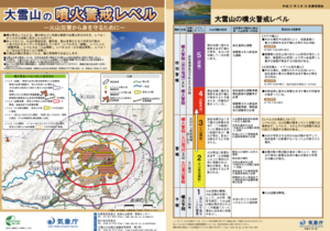
Official, Flyer, brochure, short fact-sheet, or handout
Daisetsusan Volcanic Alert Levels
Japan Meteorological Agency. (2019). Daisetsusan Volcanic Alert Levels. Volcano Monitoring and Warning Center, Volcano Division, Earthquake and Volcano Department.
Official, Figure in hazard assessment
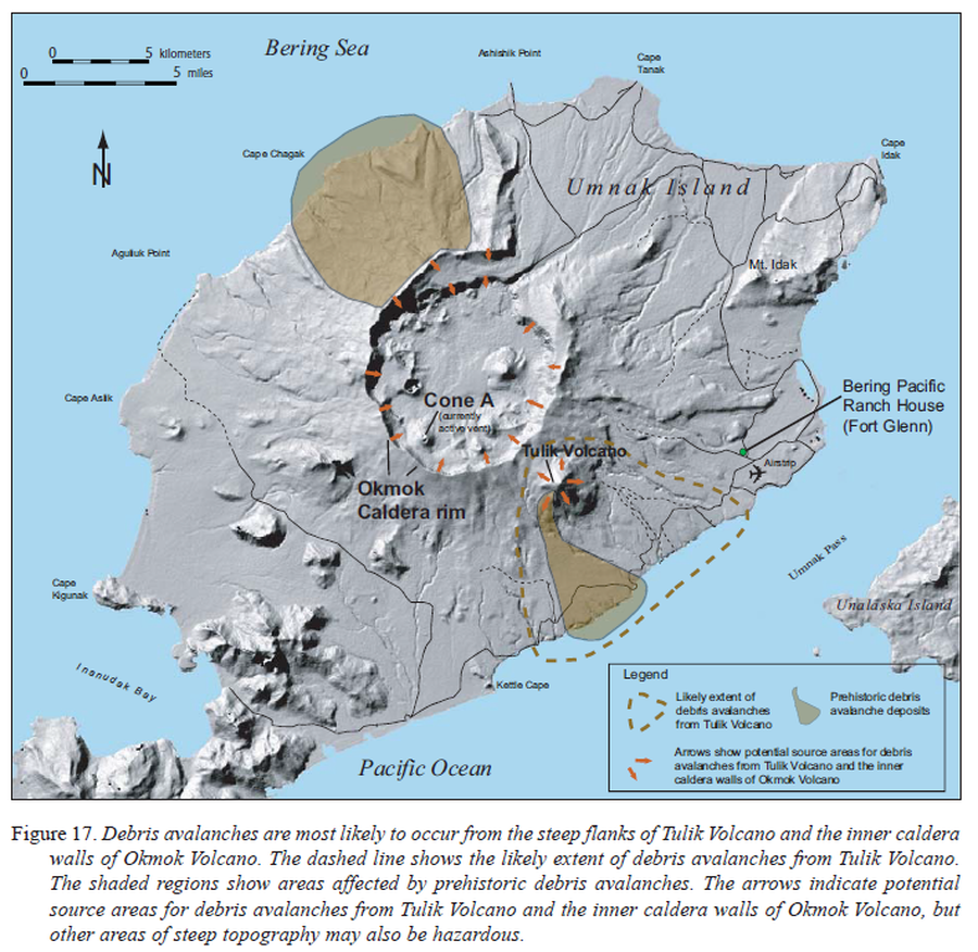
Debris avalanches are most likely to occur from the steep flanks of Tulik Volcano and the inner caldera walls of Okmok Volcano
Figure 17 in: Beget, J.E., Larsen, J.F., Neal, C.A., Nye, C.J., & Schaefer, J.R. (2005). Preliminary volcano-hazard assessment for Okmok Volcano, Umnak Island, Alaska. Department of Natural Resources, Division of Geological & Geophysical Surveys (DGGS), Report of Investigation RI 2004-3, 32 p., 1 sheet, scale 1:150,000. http://doi.org/10.14509/7042
Official, Map in a booklet, long fact-sheet, or handbook
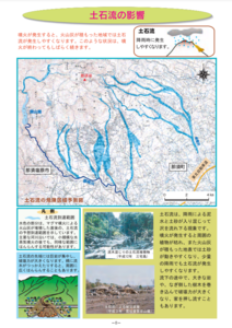
Debris flow dangerous area prediction map
Page 8 in: Nasudake Volcano Disaster Prevention Council. (2014). Nasudake Volcano Disaster Prevention Handbook.