
Advanced Search for Maps
Showing 381-390 of 2217
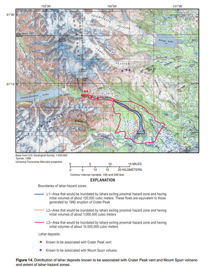
Official, Figure in hazard assessment
Distribution of lahar deposits known to be associated with Crater Peak vent and Mount Spurr volcano and extent of hazard zones
Figure 14 in: Waythomas, C.F. & Nye, C.J. (2002). Preliminary volcano-hazard assessment for Mount Spurr Volcano, Alaska. U.S. Geological Survey, Open-File Report 2001-482, 40 p., 1 plate. https://doi.org/10.3133/ofr01482
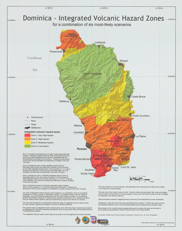
Official, Insert/poster-size map with accompanying report
Dominica - Integrated Volcanic Hazard Zones for a combination of six most-likely scenarios
Pocket insert in: Lindsay, J.M., Smith, A.L., Roobol, M.J., & Stasiuk, M.V. (2005). Dominica. Volcanic hazard atlas of the Lesser Antilles. In: Lindsay, J.M., Shepherd, J.B., Robertson, R.E.A., & Ali, S. (Eds) Volcanic hazard atlas of the Lesser Antilles. Seismic Research Unit, The University of the West Indies, Trinidad and Tobago, W.I. p. 2-47
Holuhraun (Askja) & Bárdarbunga, Iceland
Official, Map in an information statement
Dæmi um verulegt sprengigos í Dyngjujökli, jafnþykktarlínur gjóskufalls
(Example of a major explosive eruption in Dyngjujökli, equal thickness lines of tephra)
Kort Jarðvísindastofnun HÍ. (2014). Dæmi um verulegt sprengigos í Dyngjujökli, jafnþykktarlínur gjóskufalls.
Official, Map in an information statement
Dæmi um verulegt sprengigos í Dyngjujökli, jafnþykktarlínur gjóskufalls
(Example of a major explosive eruption in Dyngjujökli, equal thickness lines of tephra)
Kort Jarðvísindastofnun HÍ. (2014). Dæmi um verulegt sprengigos í Dyngjujökli, jafnþykktarlínur gjóskufalls.

Figure in a journal article
Early simulations carried out before the onset of the effusive eruption
Figure 4 in: Tarquini, S., de'Michieli Vitturi, M., Jensen, E. H., Pedersen, G. B., Barsotti, S., Coppola, D., & Pfeffer, M. A. (2018). Modeling lava flow propagation over a flat landscape by using MrLavaLoba: the case of the 2014–2015 eruption at Holuhraun, Iceland. Annals of Geophysics. https://doi.org/10.4401/ag-7812
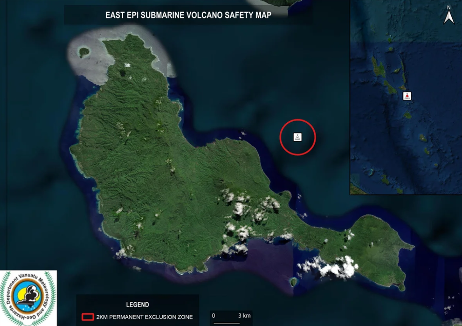
Official, Map in an information statement
East Epi Submarine Volcano Safety Map
Vanuatu Meteorology & Geo-Hazards Department. (2025). Vanuatu Volcano Alert Bulletin n°01 - East Epi Activity (Thursday March 27th 2025). Government of Vanuatu, Vanuatu Meteorology & Geo-Hazards Department.
Las Cañadas, Teide (Tenerife), Spain
Figure in a journal article
Eastern Tenerife, Canary Islands, showing the extent and percentage probability of burial by over 1 m of pumice ash
(Volcanic risk map for Guadalajara City and surrounding villages, western Mexico)
Figure 8 in: Booth, B. (1979). Assessing volcanic risk. Journal of the Geological Society, 136(3), 331-340.
Figure in a journal article
Eastern Tenerife, Canary Islands, showing the extent and percentage probability of burial by over 1 m of pumice ash
(Volcanic risk map for Guadalajara City and surrounding villages, western Mexico)
Figure 8 in: Booth, B. (1979). Assessing volcanic risk. Journal of the Geological Society, 136(3), 331-340.
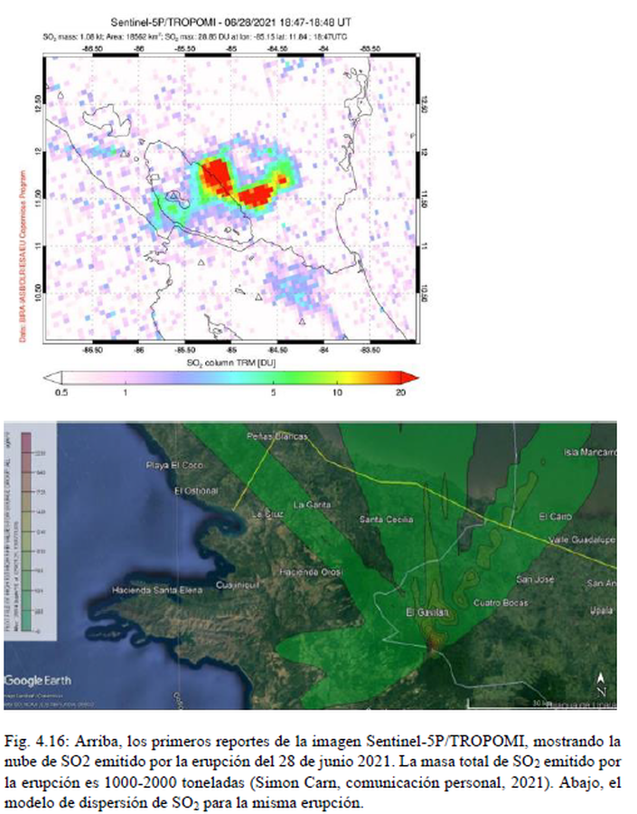
Official, Figure in hazard assessment
El modelo de dispersión de SO2 para la misma erupción
(The SO2 dispersion model for the same eruption)
Figure 4.16 in: Alvarado, G.E., Brenes-André, J., Venegas, L., Alpízar, Y., Núñez, S., Sánchez, M., Abarca, K., Abarca, J., Báez, W.A., Sibaja, J.P., Esquivel, L., & Arcia, T. (2022). Análisis del Peligro Volcánico del Rincón de la Vieja, Costa Rica. Instituto Costarricense de Electricidad (ICE). Setiembre 2022.
Official, Figure on website
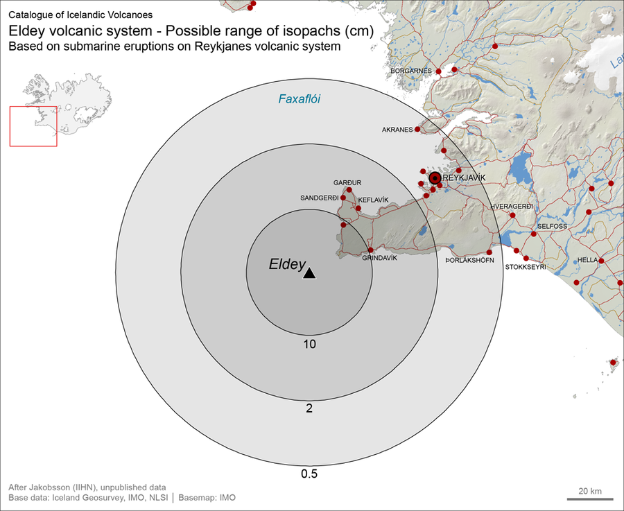
Eldey volcanic system - Possible range of isopachs (cm). Based on submarine eruptions on Reykjanes volcanic system
Larsen, G. (2019). Eldey. In: Oladottir, B., Larsen, G. & Guðmundsson, M. T. Catalogue of Icelandic Volcanoes. Iceland Meteorological Office (IMO), Univeristy of Iceland, and Civil Protection Department of the National Commissioner of the Iceland Police (CPD-NCIP). https://icelandicvolcanos.is//index.html (Simplified from: S.P. Jakobsson Unpublished data)
Eldey, Iceland
Official, Interactive web-based map
Eldey, possible range of isopachs based on submarine eruptions on Reykjanes volcanic system (cm) - After Jakobsson S.P. (Unpublished material)
Larsen, G. (2019). Eldey. In: Oladottir, B., Larsen, G. & Guðmundsson, M. T. Catalogue of Icelandic Volcanoes. Iceland Meteorological Office (IMO), Univeristy of Iceland, and Civil Protection Department of the National Commissioner of the Iceland Police (CPD-NCIP). (Simplified from: S.P. Jakobsson Unpublished data)
Official, Interactive web-based map
Eldey, possible range of isopachs based on submarine eruptions on Reykjanes volcanic system (cm) - After Jakobsson S.P. (Unpublished material)
Larsen, G. (2019). Eldey. In: Oladottir, B., Larsen, G. & Guðmundsson, M. T. Catalogue of Icelandic Volcanoes. Iceland Meteorological Office (IMO), Univeristy of Iceland, and Civil Protection Department of the National Commissioner of the Iceland Police (CPD-NCIP). (Simplified from: S.P. Jakobsson Unpublished data)
Official, Figure on website
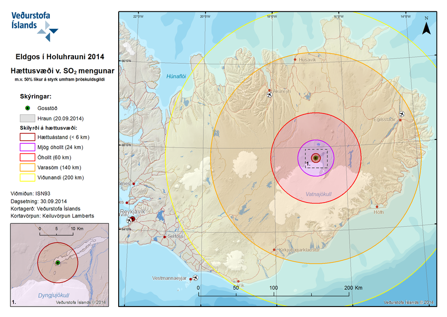
Eldgos í Holuhrauni 2014 Hættusvæði v. SO2 Mengunar m.v. 50% líkur á styrk umfram þröskuldsgildi
(Volcanic Eruption at Holuhraun 2014 Hazardous Area SO2 pollution 50% likelihood of concentration exceeding a threshold value)
Iceland Meteorological Office (IMO). (2014). Eldgos í Holuhrauni 2014 Hættusvæði v. SO2 Mengunar [Volcanic Eruption at Holuhraun 2014 Hazardous Area SO2 pollution]. (Reprinted in: Barsotti, S. (2015). Hazard Zoning: Probabilistic hazard maps of SO2 ground concentration for Holuhraun eruption. https://en.vedur.is/pollution-and-radiation/volcanic-gas/hazard-zoning/)