
Advanced Search for Maps
Showing 51-60 of 92
Official, Map sheet or poster
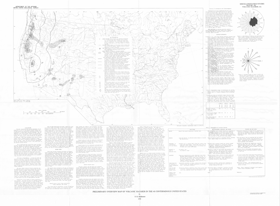
Preliminary Overview Map of Volcanic Hazards in the 48 Coterminous United States
Mullineaux, D.R. (1978). Preliminary overview map of volcanic hazards in the 48 conterminous United States. U.S. Geological Survey, Miscellaneous Field Studies Map 786. https://doi.org/10.3133/mf786
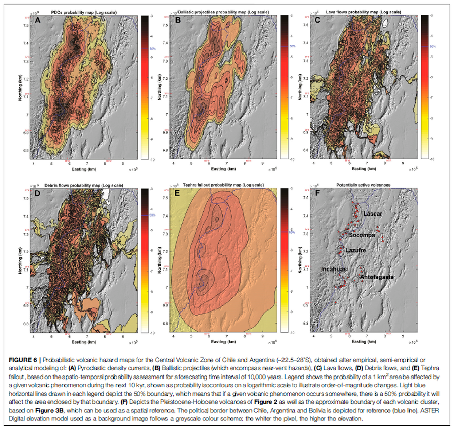
Figure in a journal article
Probabilistic volcanic hazard maps for the Central Volcanic Zone of Chile and Argentina (∼22.5–28°S), obtained after empirical, semi-empirical or analytical modeling
Figure 6 in: Bertin, D., Lindsay, J.M., Cronin, S.J., de Silva, S.L., Connor, C.B., Caffe, P.J., Grosse, P., Báez, W., Bustos, E., & Constantinescu, R. (2022). Probabilistic Volcanic Hazard Assessment of the 22.5–28° S Segment of the Central Volcanic Zone of the Andes. Frontiers in Earth Science, 10. https://doi.org/10.3389/feart.2022.875439
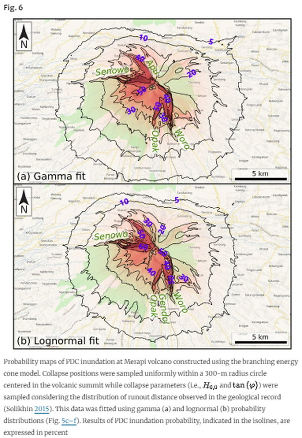
Figure in a journal article
Probability maps of PDC inundation at Merapi volcano constructed using the branching energy cone model
Figure 5 in: Aravena, A., Bevilacqua, A., de’Michieli Vitturi, M., Esposti Ongaro, T., Neri, A., & Cioni, R. (2022). Calibration strategies of PDC kinetic energy models and their application to the construction of hazard maps. Bulletin of Volcanology, 84(3), 29.
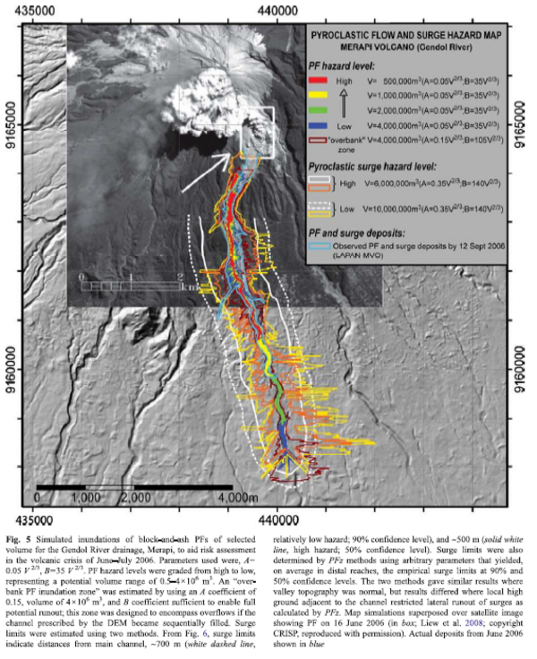
Figure in a journal article
Pyroclastic Flow and Surge Hazard Map Merapi Volcano (Gendol River)
Figure 5 in: Widiwijayanti, C., Voight, B., Hidayat, D., & Schilling, S. P. (2009). Objective rapid delineation of areas at risk from block-and-ash pyroclastic flows and surges. Bulletin of Volcanology, 71(6), p. 687-703. https://doi.org/10.1007/s00445-008-0254-6
Official, Figure in a journal article
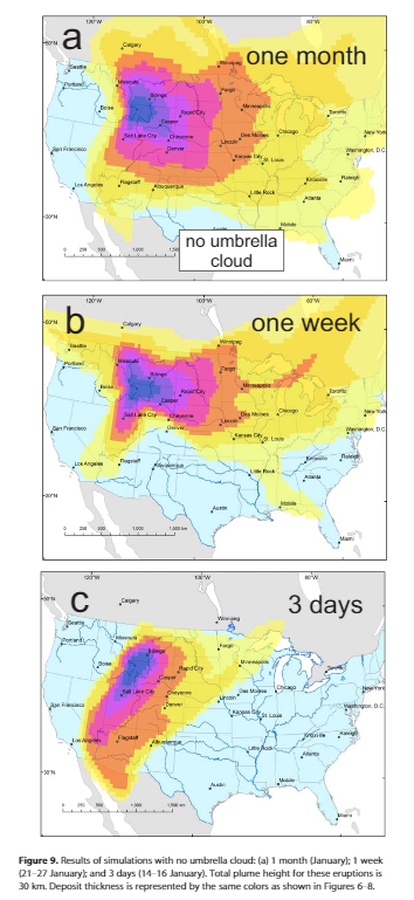
Results of simulations with no umbrella cloud: (a) 1 month (January); 1 week(21–27 January); and 3 days (14–16 January
Figure 9 in: Mastin, L.G., Van Eaton, A.R., & Lowenstern, J.B. (2014). Modeling ash fall distribution from a Yellowstone supereruption. Geochemistry, Geophysics, Geosystems, 15(8), 3459-3475. https://doi.org/10.1002/2014GC005469
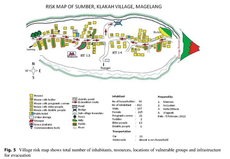
Figure in a journal article
Risk Map of Sumber, Klakah Village, Magelang
Figure 5 (in reprint) in: Marmen, Sri Lestari, Sinta Oktavia, & Waginah. (2012). Risk Map of Sumber, Klakah Village, Magelang. (Reprinted in: Andreastuti, S., Budianto, A., & Paripurno, E.T. (2017). Integrating social and physical perspectives of mitigation policy and practice in Indonesia. In: Fearnley, C.J., Bird, D.K., Haynes, K., McGuire, W.J., Jolly, G. (Eds.) Observing the Volcano World (p. 307-320). Springer, Cham. https://doi.org/10.1007/11157_2016_36.)
Official, Figure in a journal article
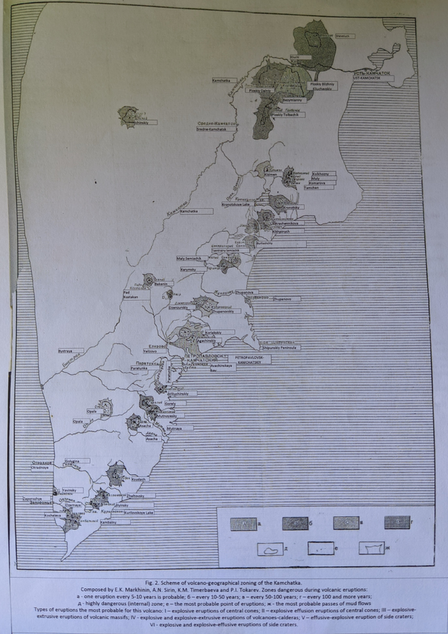
Scheme of volcano-geographical zoning in Kamchatka
Figure 2 in: Markhinin, E. K., Sirin, A. N., Timerbayeva, K. M., & Tokarev, P. I. (1962). Experience of volcanic-geographic zoning of Kamchatka and Kuril Islands. Bulletin of the Volcanological Station, Petropavlousk, Kamchatskiy, USSR, 32, 52-70.
Official, Figure in a journal article
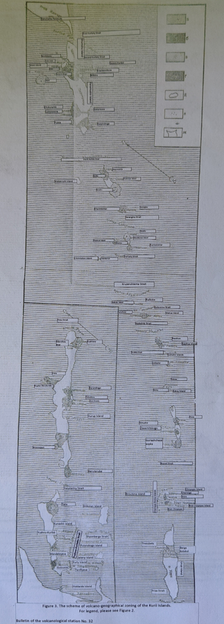
Scheme of volcano-geographical zoning in the Kuril Islands
Figure 3 in: Markhinin, E. K., Sirin, A. N., Timerbayeva, K. M., & Tokarev, P. I. (1962). Experience of volcanic-geographic zoning of Kamchatka and Kuril Islands. Bulletin of the Volcanological Station, Petropavlousk, Kamchatskiy, USSR, 32, 52-70.
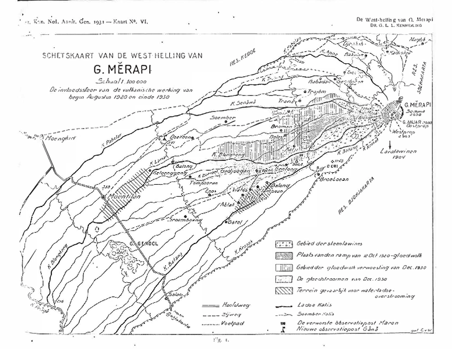
Official, Figure in hazard assessment
SCHETSKAART VAN DE WESTELIJKE HELLING VAN G. MERAPI. De invloedssfeer van de vulkanische activiteit van begin augustus 1920 tot eind 1930.
(Sketch map of the west slope of G. Merapi. The sphere of influence of the volcanic activity from early August 1920 and late 1930.)
Figure 1 in: Kemmerling, G. L. L. (1931). Beschouwingen over de hernieuwde werking van den Merapi der vorstenlanden van December 1930. Koninkl. Nederl. Aardrijksk. Genoot. Tijdschr, 48, 712-743.

Official, Insert/poster-size map with accompanying report
Schetskaart van een deel van de west-helling van G. Merapi. De invloedssfeer van de hernieuwde vulkanische werking van G. Merapi, sedert begin Augustus 1920.
(Sketch map of part of the western slope of Mount Merapi. The area of influence of Mount Merapi's renewed volcanic activity since early August 1920.)
Plate 1 in: Kemmerling, G. L. L. (1921). De hernieuwde werking van den vulkaan G. Merapi (Midden Java) van begin Augustus: 1920 tot en met einde Februari 1921. Vulkanologische Mededeelingen, No. 3.