
Advanced Search for Maps
Showing 1-10 of 17
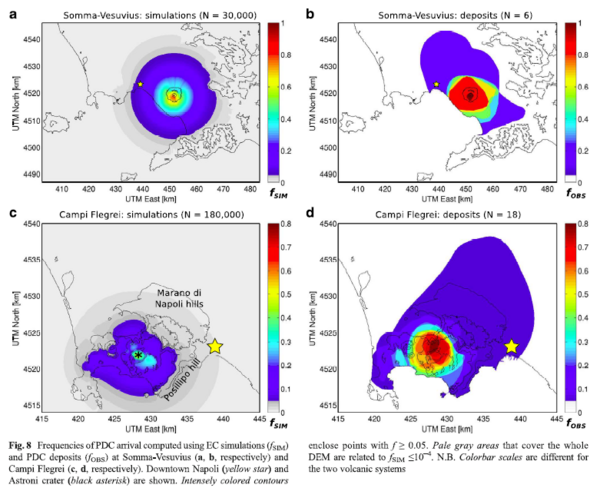
Figure in a journal article
Frequencies of PDC arrival computed using EC simulations and PDC deposits at Somma-Vesuvius and Campi Flegrei
Figure 8a-b in: Tierz, P., Sandri, L., Costa, A., Zaccarelli, L., Di Vito, M. A., Sulpizio, R., & Marzocchi, W. (2016). Suitability of energy cone for probabilistic volcanic hazard assessment: validation tests at Somma-Vesuvius and Campi Flegrei (Italy). Bulletin of Volcanology, 78(11). https://doi.org/10.1007/s00445-016-1073-9
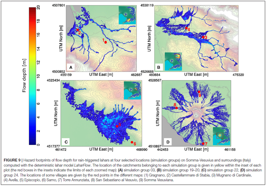
Figure in a journal article
Hazard footprints of flow depth for rain-triggered lahars at four selected locations (simulation groups) on Somma-Vesuvius and surroundings (Italy) computed with the deterministic lahar model LaharFlow
Figure 9 in: Tierz, P., Woodhouse, M.J., Phillips, J.C., Sandri, L., Selva, J., Marzocchi, W., & Odbert, H.M. (2017). A framework for probabilistic multi-hazard assessment of rain-triggered lahars using Bayesian belief networks. Frontiers in Earth Science, 5 (73). https://doi.org/10.3389/feart.2017.00073
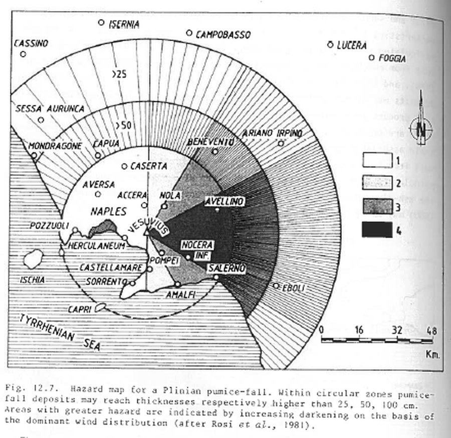
Figure in a journal article
Hazard map for a Plinian pumice-fall
Figure 12.7 in: Barberi, F., Rosi, M., Santacroce, R., & Sheridan, M.F. (1983). Volcanic hazard zonation: Mt. Vesuvius. In: Tazieff, H. & Sabroux, J.-C. (Eds.) Forecasting Volcanic Events, Elsevier, Amsterdam, p. 149-161.
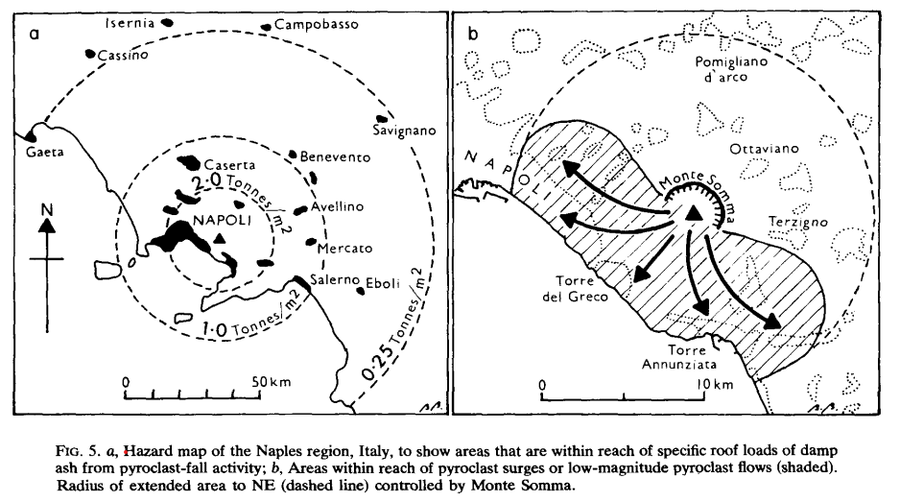
Figure in a journal article
Hazard map of the Naples region, Italy
Figure 5 in: Booth, B. (1979). Assessing volcanic risk. Journal of the Geological Society, 136(3), 331-340.
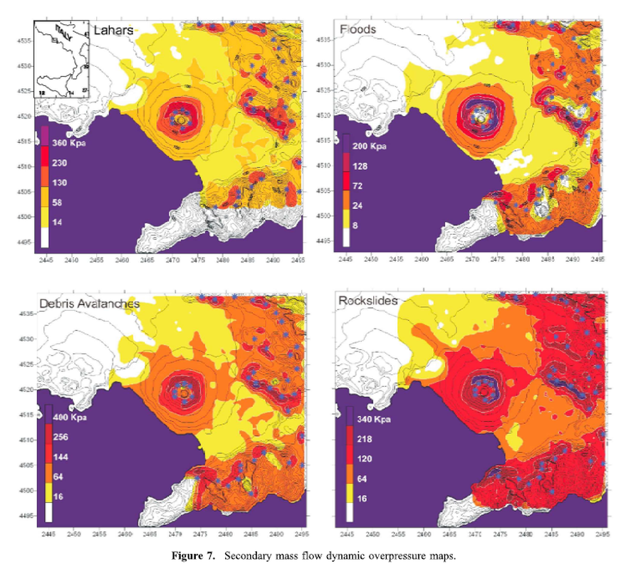
Figure in a journal article
Lahars, Floods, Debris Avalanches, Rockslides
Figure 7 in: Mastrolorenzo, G., & Pappalardo, L. (2010). Hazard assessment of explosive volcanism at Somma‐Vesuvius. Journal of Geophysical Research: Solid Earth, 115(B12). https://doi.org/10.1029/2009JB006871
Official, Figure in hazard assessment
Mappe Zona Rossa Area Vesuviana – Nuovo Scenario
(Vesuvius Area Red Zone Maps -- New Scenario)
Dipartimento della Protezione Civile. (2013). Mappe Zona Rossa Area Vesuviana – Nuovo Scenario.
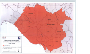
Official, Map sheet or poster
Pianificazione di emergenza per rischio vulcanico del Vesuvio Zona Rossa
(Emergency planning for volcanic risk of Vesuvius Red Zone)
Dipartimento della Protezione Civile. (2014). Pianificazione di emergenza per rischio vulcanico del Vesuvio Zona Rossa.
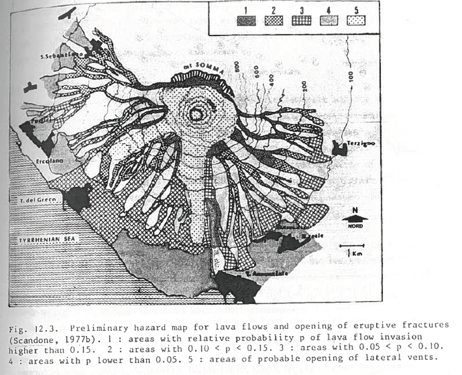
Figure in a journal article
Preliminary hazard map for lava flows and opening of eruptive fractures
Figure 12.3 (in reprint) in: Scandone, R. (1977). Il rischio di colate di lava e implicazioni socio-economiche. Proceedings of the Congress: I Vulcani Attivi dell'Area Napoletana, Naples (23-25 June 1977) (Reprinted in: Barberi, F., Rosi, M., Santacroce, R., & Sheridan, M.F. (1983). Volcanic hazard zonation: Mt. Vesuvius. In: Tazieff, H. & Sabroux, J.-C. (Eds.) Forecasting Volcanic Events, Elsevier, Amsterdam, p. 149-161.
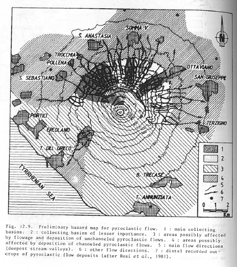
Figure in a journal article
Preliminary hazard map for pyroclastic flows
Figure 12.9 in: Barberi, F., Rosi, M., Santacroce, R., & Sheridan, M.F. (1983). Volcanic hazard zonation: Mt. Vesuvius. In: Tazieff, H. & Sabroux, J.-C. (Eds.) Forecasting Volcanic Events, Elsevier, Amsterdam, p. 149-161.
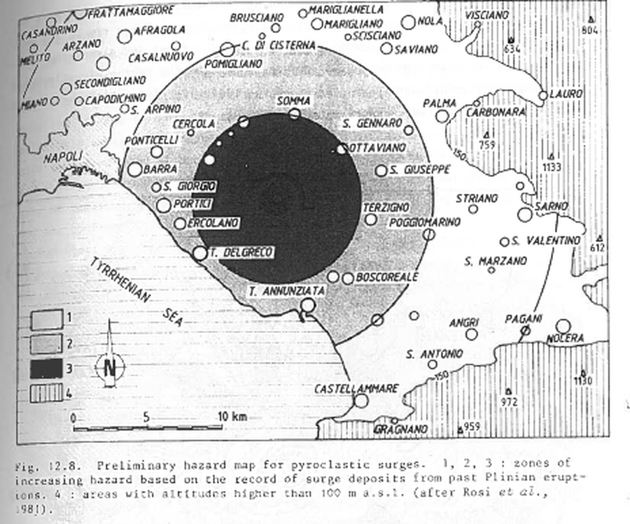
Figure in a journal article
Preliminary hazard map for pyroclastic surges
Figure 12.8 in: Barberi, F., Rosi, M., Santacroce, R., & Sheridan, M.F. (1983). Volcanic hazard zonation: Mt. Vesuvius. In: Tazieff, H. & Sabroux, J.-C. (Eds.) Forecasting Volcanic Events, Elsevier, Amsterdam, p. 149-161.
Page: 1 2