
Advanced Search for Maps
Showing 1-10 of 24
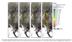
Figure in a journal article
Ballistic vulnerability or probability of casualty assuming an eruption during the time of exposure, along the Tongariro Alpine Crossing
Figure 12 in: Fitzgerald, R. H., Tsunematsu, K., Kennedy, B. M., Breard, E. C. P., Lube, G., Wilson, T. M., Jolly, A.D., Pawson, J., Rosenburg, M.D., & Cronin, S. J. (2014). The application of a calibrated 3D ballistic trajectory model to ballistic hazard assessments at Upper Te Maari, Tongariro. Journal of volcanology and geothermal research, 286, p. 248-262. https://doi.org/10.1016/j.jvolgeores.2014.04.006
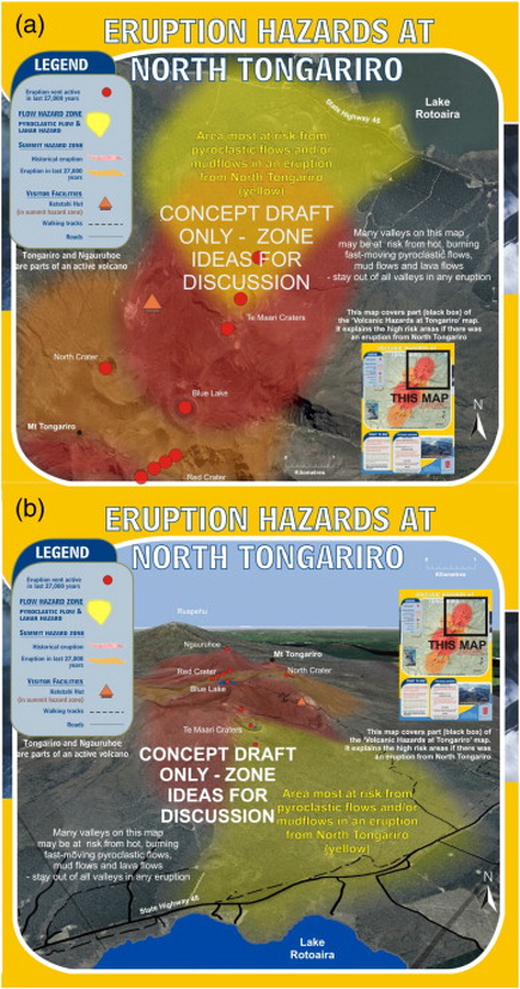
Official, Map sheet or poster
Eruption Hazards at North Tongariro
GNS Science (compiler). (2012). Te Maari Eruption Phenomena. Version 0.1, 6 August 2012. (Reprinted in: Leonard, G. S., Stewart, C., Wilson, T. M., Procter, J. N., Scott, B. J., Keys, H. J., Jolly, G.E., Wardman, J.B., Cronin. S.J. & McBride, S. K. (2014). Integrating multidisciplinary science, modelling and impact data into evolving, syn-event volcanic hazard mapping and communication: a case study from the 2012 Tongariro eruption crisis, New Zealand. Journal of Volcanology and Geothermal Research, 286, p. 208-232. https://doi.org/10.1016/j.jvolgeores.2014.08.018)
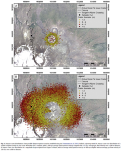
Figure in a journal article
Impact crater distributions from possible future eruption scenarios modelled using the Tsunematsu et al. (2013) ballistic trajectory model
Figure 11 in: Fitzgerald, R. H., Tsunematsu, K., Kennedy, B. M., Breard, E. C. P., Lube, G., Wilson, T. M., Jolly, A.D., Pawson, J., Rosenburg, M.D., & Cronin, S. J. (2014). The application of a calibrated 3D ballistic trajectory model to ballistic hazard assessments at Upper Te Maari, Tongariro. Journal of volcanology and geothermal research, 286, p. 248-262. https://doi.org/10.1016/j.jvolgeores.2014.04.006
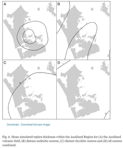
Figure in a journal article
Mean simulated tephra thickness within the Auckland Region
Figure 6 in: Magill, C. R., Hurst, A. W., Hunter, L. J., & Blong, R. J. (2006). Probabilistic tephra fall simulation for the Auckland Region, New Zealand. Journal of volcanology and geothermal research, 153(3-4), 370-386. https://doi.org/10.1016/j.jvolgeores.2005.12.002
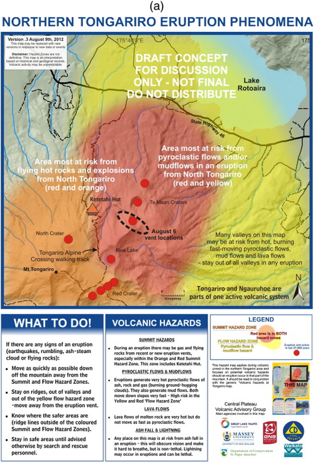
Official, Map sheet or poster
Northern Tongariro Eruption Phenomena
GNS Science (compiler). (2012). Te Maari Eruption Phenomena. Version 0.3, 9 August 2012. (Reprinted in: Leonard, G. S., Stewart, C., Wilson, T. M., Procter, J. N., Scott, B. J., Keys, H. J., Jolly, G.E., Wardman, J.B., Cronin. S.J. & McBride, S. K. (2014). Integrating multidisciplinary science, modelling and impact data into evolving, syn-event volcanic hazard mapping and communication: a case study from the 2012 Tongariro eruption crisis, New Zealand. Journal of Volcanology and Geothermal Research, 286, p. 208-232. https://doi.org/10.1016/j.jvolgeores.2014.08.018)
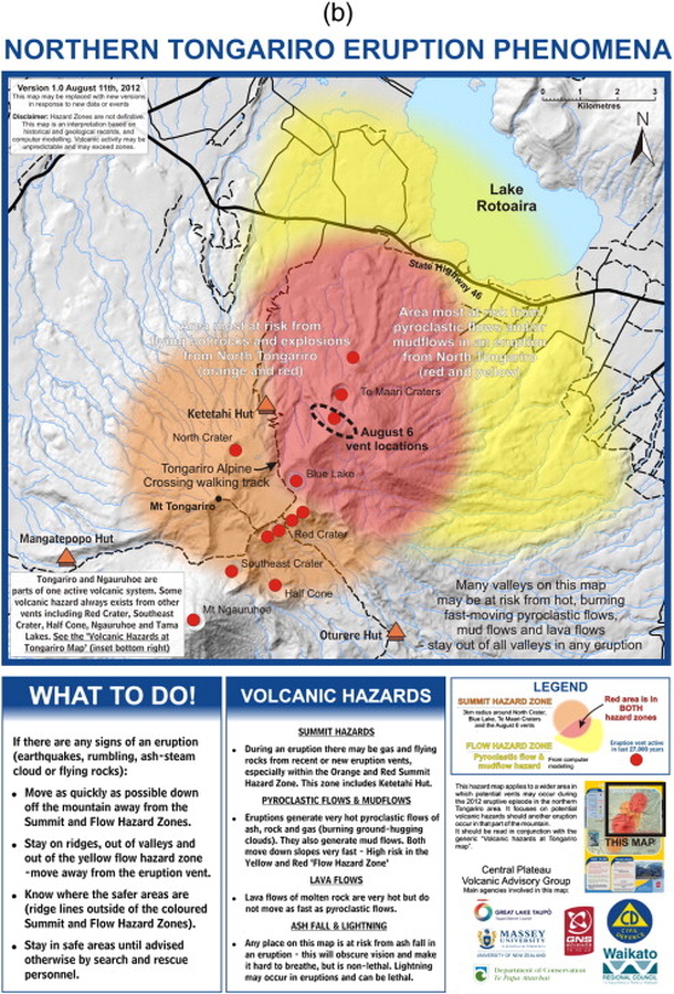
Official, Map sheet or poster
Northern Tongariro Eruption Phenomena
GNS Science (compiler). (2012). Te Maari Eruption Phenomena. Version 1.0, 11 August 2012. (Reprinted in: Leonard, G. S., Stewart, C., Wilson, T. M., Procter, J. N., Scott, B. J., Keys, H. J., Jolly, G.E., Wardman, J.B., Cronin. S.J. & McBride, S. K. (2014). Integrating multidisciplinary science, modelling and impact data into evolving, syn-event volcanic hazard mapping and communication: a case study from the 2012 Tongariro eruption crisis, New Zealand. Journal of Volcanology and Geothermal Research, 286, p. 208-232. https://doi.org/10.1016/j.jvolgeores.2014.08.018)
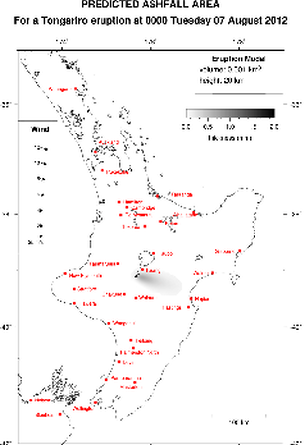
Official, Map in an information statement
Predicted Ashfall Area for a Tongariro eruption at 0000 Tuesday 07 August 2012
GNS Science. (2012). Volcanic Alert Bulletin TON2012-06.
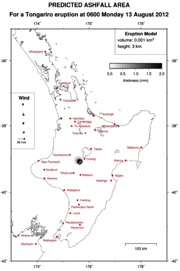
Official, Map in an information statement
Predicted Ashfall Area for a Tongariro eruption at 0600 Monday 13 August 2012
GNS Science. (2012). Volcanic Alert Bulletin TON2012-17. (Reprinted in: Leonard, G. S., Stewart, C., Wilson, T. M., Procter, J. N., Scott, B. J., Keys, H. J., Jolly, G.E., Wardman, J.B., Cronin. S.J. & McBride, S. K. (2014). Integrating multidisciplinary science, modelling and impact data into evolving, syn-event volcanic hazard mapping and communication: a case study from the 2012 Tongariro eruption crisis, New Zealand. Journal of Volcanology and Geothermal Research, 286, p. 208-232. https://doi.org/10.1016/j.jvolgeores.2014.08.018)
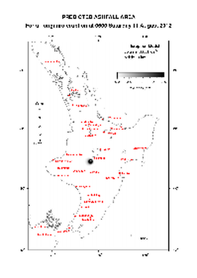
Official, Map in an information statement
Predicted Ashfall Area for a Tongariro eruption at 0600 Saturday 11 August 2012
GNS Science. (2012). Volcanic Alert Bulletin TON2012-14.
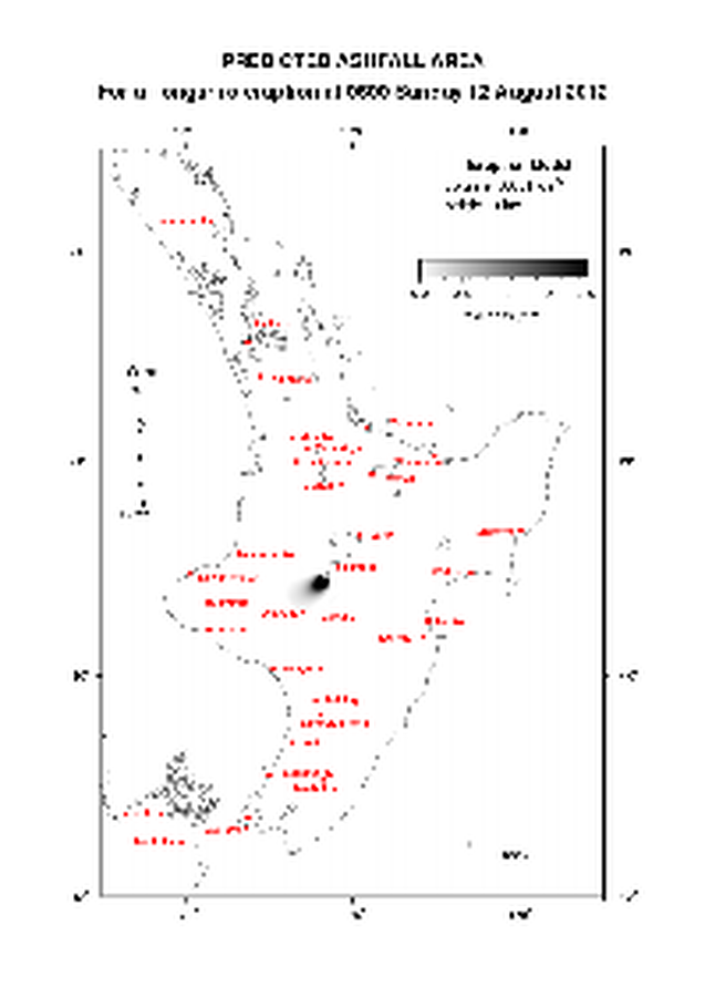
Official, Map in an information statement
Predicted Ashfall Area for a Tongariro eruption at 0600 Sunday 12 August 2012
GNS Science. (2012). Volcanic Alert Bulletin TON2012-16.