
Advanced Search for Maps
Showing 1-8 of 8
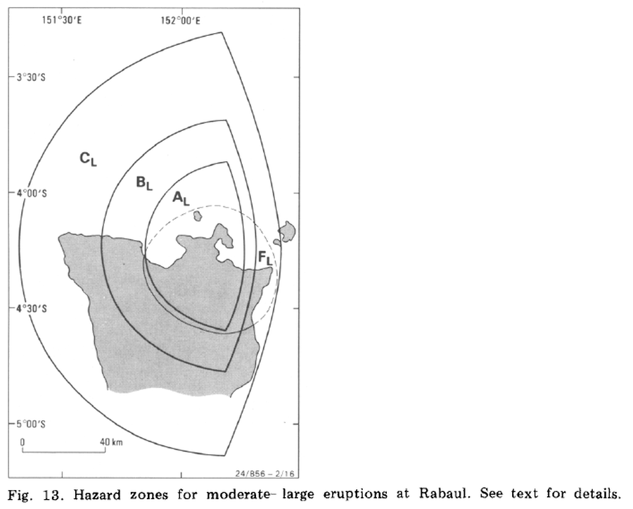
Official, Figure in a journal article
Hazard zones for moderate-large eruptions at Rabaul
Figure 13 in: McKee, C. O., Johnson, R. W., Lowenstein, P. L., Riley, S. J., Blong, R. J., De Saint Ours, P., & Talai, B. (1985). Rabaul caldera, Papua New Guinea: volcanic hazards, surveillance, and eruption contingency planning. Journal of Volcanology and Geothermal Research, 23(3-4), p. 195-237. https://doi.org/10.1016/0377-0273(85)90035-6
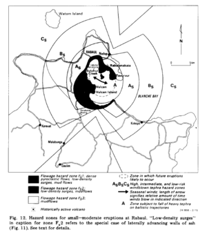
Official, Figure in a journal article
Hazard zones for small--moderate eruptions at Rabaul
Figure 12 in: McKee, C. O., Johnson, R. W., Lowenstein, P. L., Riley, S. J., Blong, R. J., De Saint Ours, P., & Talai, B. (1985). Rabaul caldera, Papua New Guinea: volcanic hazards, surveillance, and eruption contingency planning. Journal of Volcanology and Geothermal Research, 23(3-4), p. 195-237. https://doi.org/10.1016/0377-0273(85)90035-6
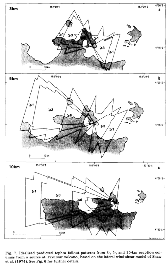
Official, Figure in a journal article
Idealized predicted tephra fallout patterns from 3-, 5-, and 10-km eruption columns from a source at Tavurvur volcano
Figure 7 in: McKee, C. O., Johnson, R. W., Lowenstein, P. L., Riley, S. J., Blong, R. J., De Saint Ours, P., & Talai, B. (1985). Rabaul caldera, Papua New Guinea: volcanic hazards, surveillance, and eruption contingency planning. Journal of Volcanology and Geothermal Research, 23(3-4), p. 195-237. https://doi.org/10.1016/0377-0273(85)90035-6
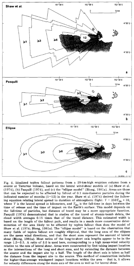
Official, Figure in a journal article
Idealized tephra fallout patterns from a 20-km-high eruption column from a source at Tavurvur volcano
Figure 6 in: McKee, C. O., Johnson, R. W., Lowenstein, P. L., Riley, S. J., Blong, R. J., De Saint Ours, P., & Talai, B. (1985). Rabaul caldera, Papua New Guinea: volcanic hazards, surveillance, and eruption contingency planning. Journal of Volcanology and Geothermal Research, 23(3-4), p. 195-237. https://doi.org/10.1016/0377-0273(85)90035-6
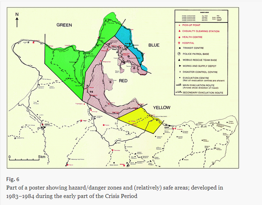
Official, Map sheet or poster
Part of a poster showing hazard/danger zones and (relatively) safe areas; developed in 1983–1984 during the early part of the Crisis Period
Figure 6 (in reprint) in: RVO. (1984). (Reprinted in: McKee C., Itikarai I., & Davies H. (2017). Instrumental Volcano Surveillance and Community Awareness in the Lead-Up to the 1994 Eruptions at Rabaul, Papua New Guinea. In: Fearnley C.J., Bird D.K., Haynes K., McGuire W.J., & Jolly G. (eds) Observing the Volcano World. Advances in Volcanology (An Official Book Series of the International Association of Volcanology and Chemistry of the Earth’s Interior – IAVCEI, Barcelona, Spain). Springer, Cham. https://doi.org/10.1007/11157_2017_4)
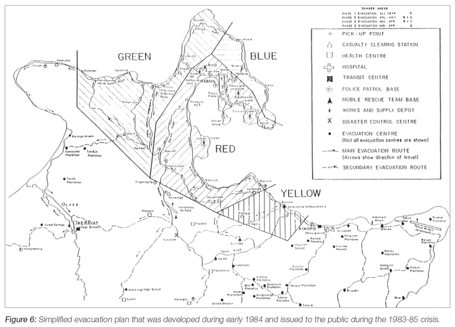
Official, Figure in hazard assessment
Simplified evacuation plan that was developed during early 1984 and issued to the public during the 1983-85 crisis
Figure 6 (in reprint) in: RVO. (1984). (Reprinted in: Talai, B. (2016). Volcanic Crises Case Histories Rabaul Volcano, 1983-85, 1994-97. In: Taylor, P.W. (Ed.) Volcanic Hazards and Emergency Management in the Southwest Pacific, SPC Technical Bulletin, SPC00017, p. 110-118)
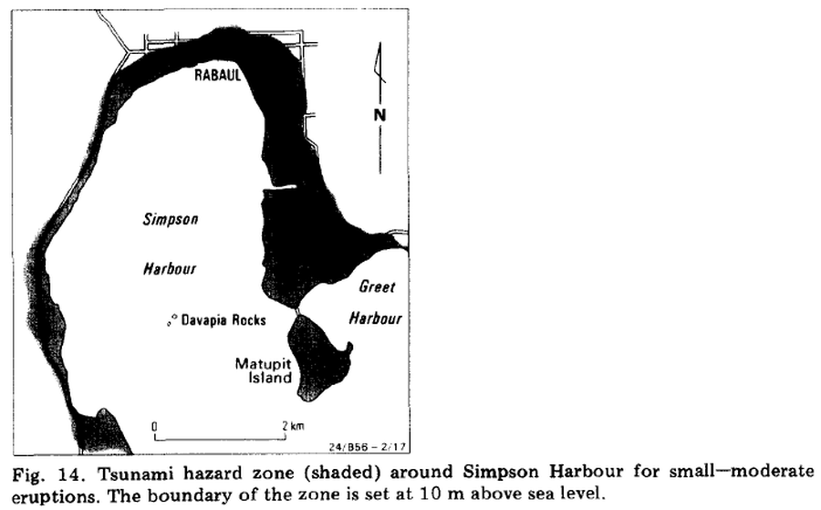
Official, Figure in a journal article
Tsunami hazard zone around Simpson Harbour for small--moderate eruptions
Figure 14 in: McKee, C. O., Johnson, R. W., Lowenstein, P. L., Riley, S. J., Blong, R. J., De Saint Ours, P., & Talai, B. (1985). Rabaul caldera, Papua New Guinea: volcanic hazards, surveillance, and eruption contingency planning. Journal of Volcanology and Geothermal Research, 23(3-4), p. 195-237. https://doi.org/10.1016/0377-0273(85)90035-6
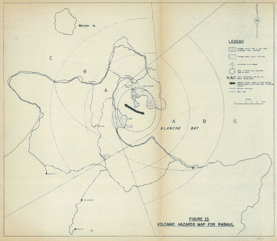
Official, Figure in hazard assessment
Volcanic Hazards Map for Rabaul
Figure 15 in: Lowenstein, P.L. (1982). Problems of volcanic hazards in Papua New Guinea. Geological Survey of Papua New Guinea, Report 82/7, 62 p.