Advanced Search for Maps
Showing 1-7 of 7

Official, Map in an information statement
Ambrym Caldera Safety Map
Vanuatu Meteorology & Geo-Hazards Department. (2025). Vanuatu Volcano Alert Bulletin n°01 - Ambrym Activity (Thursday March 27th 2025). Government of Vanuatu, Vanuatu Meteorology & Geo-Hazards Department.

Official, Map sheet or poster
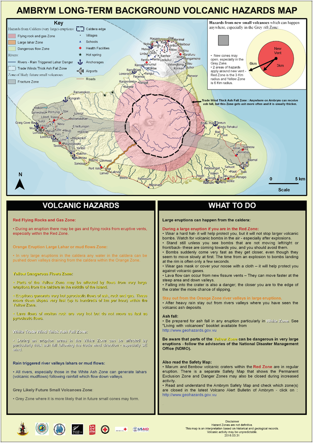
Ambrym Long-Term Background Volcanic Hazards Map
Vanuatu Meteorology & Geo-Hazards Department. (2016). Ambrym Long-Term Background Volcanic Hazards Map. Government of Vanuatu, Vanuatu Meteorology & Geo-Hazards Department, Vanuatu National Disaster Risk Management Office, New Zealand Foreign Affairs & Trade Aid Programme, GNS Science, The Vanuatu Red Cross Society, Croix Rouge Francaise, USAID.

Official, Map sheet or poster
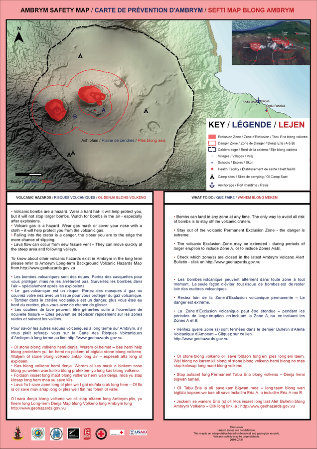
Ambrym Safety Map
Vanuatu Meteorology & Geo-Hazards Department. (2016). Ambrym Safety Map. Government of Vanuatu, Vanuatu Meteorology & Geo-Hazards Department, Vanuatu National Disaster Risk Management Office, New Zealand Foreign Affairs & Trade Aid Programme, GNS Science.

Official, Map sheet or poster
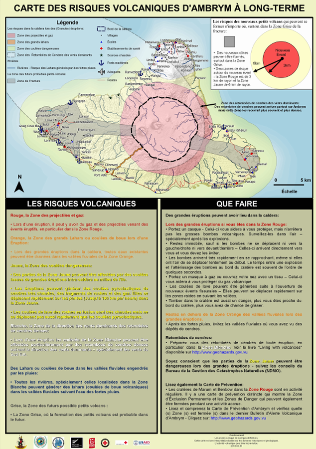
Carte des Risques Volcaniques d'Ambrym à Long-terme
(Ambrym Long-Term Background Volcanic Hazards Map)
Vanuatu Meteorology & Geo-Hazards Department. (2016). Carte des Risques Volcaniques d'Ambrym à Long-terme. Government of Vanuatu, Vanuatu Meteorology & Geo-Hazards Department, Vanuatu National Disaster Risk Management Office, New Zealand Foreign Affairs & Trade Aid Programme, GNS Science, The Vanuatu Red Cross Society, Croix Rouge Francaise, USAID.

Official, Map sheet or poster
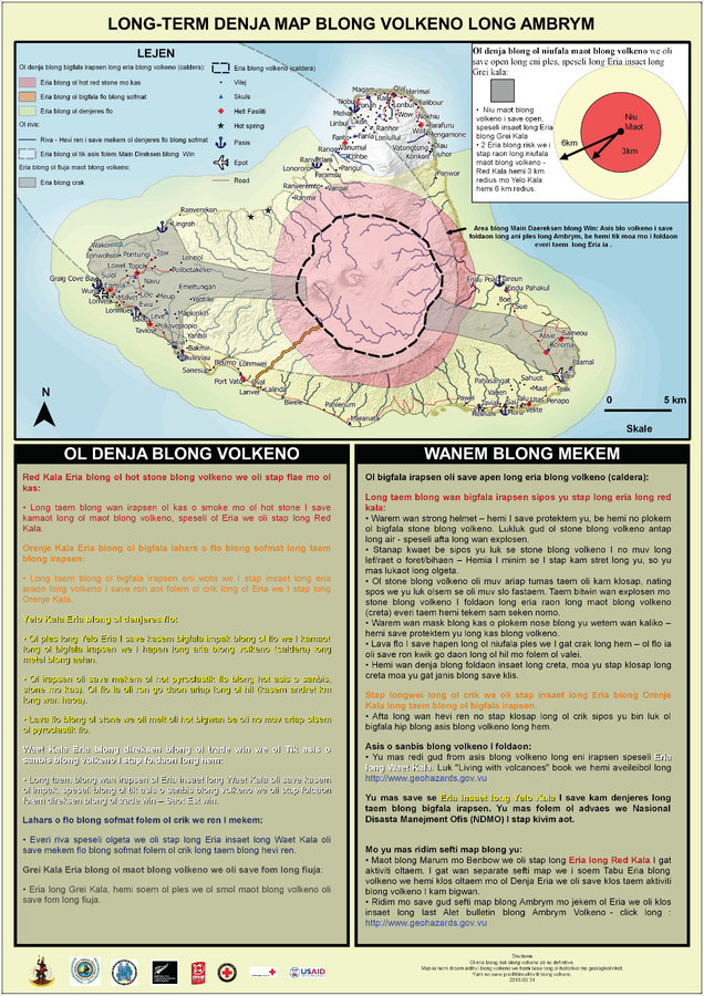
Long-term Denja Map Blong Volkeno Long Ambrym
(Ambrym Long-Term Background Volcanic Hazards Map)
Vanuatu Meteorology & Geo-Hazards Department. (2016). Long-term Denja Map Blong Volkeno Long Ambrym. Government of Vanuatu, Vanuatu Meteorology & Geo-Hazards Department, Vanuatu National Disaster Risk Management Office, New Zealand Foreign Affairs & Trade Aid Programme, GNS Science, The Vanuatu Red Cross Society, Croix Rouge Francaise, USAID.

Official, Figure in hazard assessment
Volcanic Hazard Map for Ambrym Island - Carte des Menaces Volcaniques pour l'Ile d'Ambrym (Vanuatu)
Appendix 1, Page 103 (in reprint) in: Monzier, M. & Robin, C. (1996). Volcanic Hazard Map for Ambrym Island - Carte des Menaces Volcaniques pour l'Ile d'Ambrym (Vanuatu). ORSTOM. (Reprinted in: Esau Wate, J. (2016). National Disaster Management Structure, Volcanic Alert Levels, Emergency Evacuation Plans and Public Awareness Strategies for Vanuatu. In: Taylor, P.W. (Ed.) Volcanic Hazards and Emergency Management in the Southwest Pacific, SPC Technical Bulletin, SPC00017, p. 96-105.)

Official, Flyer, brochure, short fact-sheet, or handout
Volcano Fact Sheet Ambrym Volcano
Vanuatu Meteorology & Geo-Hazards Department. Volcano Fact Sheet Ambrym Volcano. Government of Vanuatu, Vanuatu Meteorology & Geo-Hazards Department, Vanuatu National Disaster Risk Management Office, New Zealand Foreign Affairs & Trade Aid Programme, GNS Science.
