
Advanced Search for Maps
Showing 1-10 of 21

Figure in a thesis or dissertation
Batur Community Hazard Map
Figure 5.5 in: Donovan, K.H.M. (2010). Cultural responses to volcanic hazards on Mt Merapi, Indonesia. University of Plymouth, PhD Dissertation.
Official, Insert/poster-size map with accompanying report
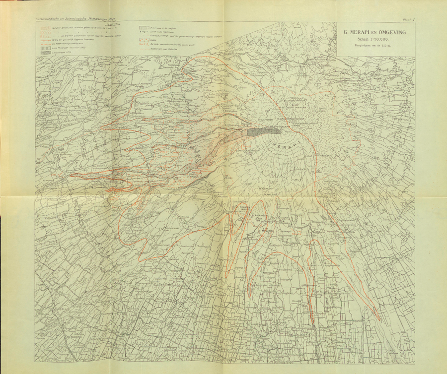
G. Merapi en Omgeving
(G. Merapi and Surroundings)
Plate 1 in: Neumann van Padang, M. (1933). De uitbarsting van den Merapi: (Midden java) in de jaren 1930-1931. Vukanologische en Seismologische Mededeelingen, No. 12.
Official, Map in a booklet, long fact-sheet, or handbook
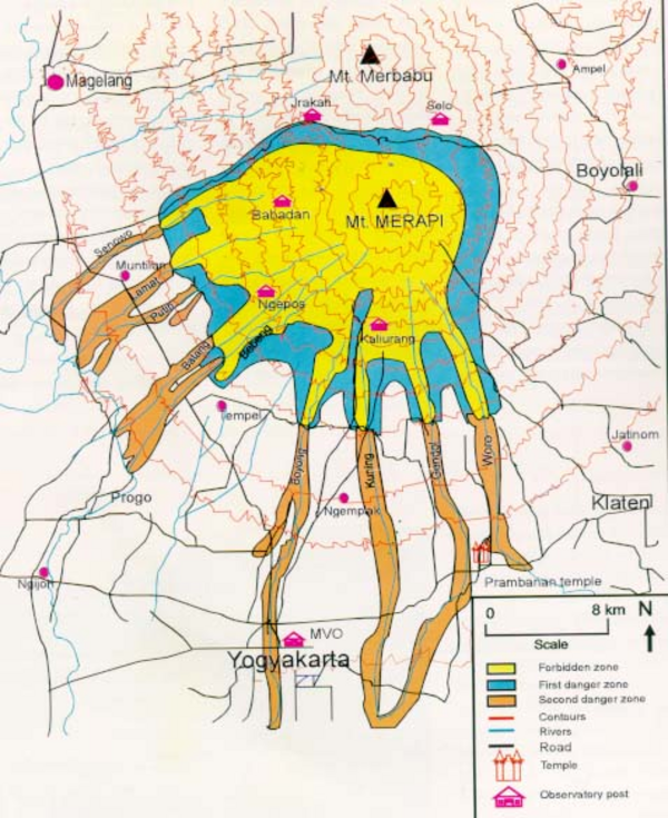
Hazard Map of Merapi
Purbawinata, M. A., Ratdomopurbo, A., Sinulingga, I. K., Sumarti, S., & Suharno, I. (1996). Merapi volcano – guide book. Volcanological Survey of Indonesia (VSI), Bandung. (Reprinted in: Gerstenecker, C., Läufer, G., Steineck, D., Tiede, C., & Wrobel, B. (2005). Validation of digital elevation models around Merapi Volcano, Java, Indonesia. Natural Hazards and Earth System Sciences, 5(6), 863-876. https://doi.org/10.5194/nhess-5-863-2005)
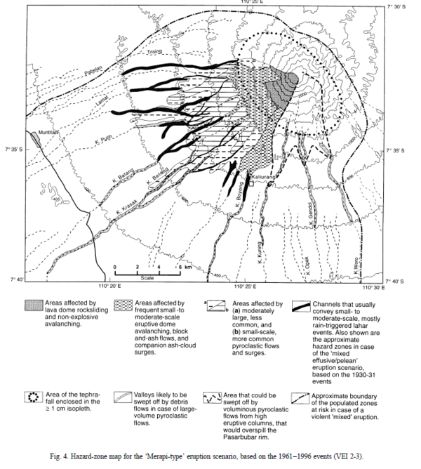
Figure in a journal article
Hazard-zone map for the 'Merapi-type' eruption scenario, based on the 1961-1996 events (VEI 2-3)
Figure 4 in: Thouret, J.-C., Lavigne, F., Kelfoun, K., & Bronto, S. (2000). Toward a revised hazard assessment at Merapi volcano, Central Java. Journal of Volcanology and Geothermal Research, 100(1-4), p. 479-502. https://doi.org/10.1016/S0377-0273(00)00152-9
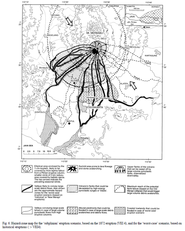
Figure in a journal article
Hazard-zone map for the 'subplinian' eruption scenario, based on the 1872 eruption (VEI 4), and for the 'worst-case' scenario, based on historical eruptions (>VEI 4)
Figure 6 in: Thouret, J.-C., Lavigne, F., Kelfoun, K., & Bronto, S. (2000). Toward a revised hazard assessment at Merapi volcano, Central Java. Journal of Volcanology and Geothermal Research, 100(1-4), p. 479-502. https://doi.org/10.1016/S0377-0273(00)00152-9
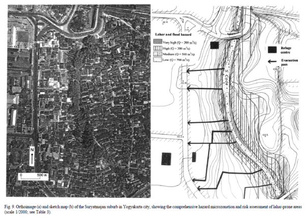
Figure in a journal article
Lahar and flood hazard
Figure 9 in: Thouret, J.-C., Lavigne, F., Kelfoun, K., & Bronto, S. (2000). Toward a revised hazard assessment at Merapi volcano, Central Java. Journal of Volcanology and Geothermal Research, 100(1-4), p. 479-502. https://doi.org/10.1016/S0377-0273(00)00152-9
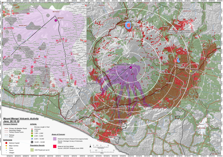
Unknown format
Mount Merapi Volcanic Activity Java, 26.10.10
World Food Programme. (2010). Indonesia: Java - Mount Merapi Volcanic Activity - as of 26 Oct 2010.
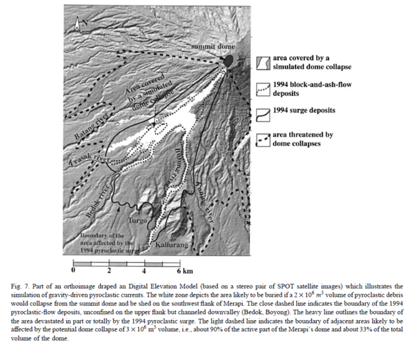
Figure in a journal article
Part of an orthoimage draped Digital Elevation Model which illustrated the simulation of gravity-driven pyroclastic currents.
Figure 7 in: Thouret, J.-C., Lavigne, F., Kelfoun, K., & Bronto, S. (2000). Toward a revised hazard assessment at Merapi volcano, Central Java. Journal of Volcanology and Geothermal Research, 100(1-4), p. 479-502. https://doi.org/10.1016/S0377-0273(00)00152-9
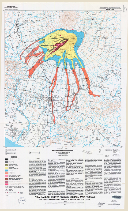
Official, Map sheet or poster
Peta Daerah Bahaya Gunung Merapi, Jawa Tengah
(Volcanic Hazard Map Merapi Volcano, Central Java)
Pardyanto, L., Reksowirogo, L.D., Mitrohartono, F.X.S., & Hardjowarsito, S.H. (1978). Peta Daerah Bahaya Gunung Merapi, Jawa Tengah (Volcanic Hazard Map Merapi Volcano, Central Java). Geological Survey of Indonesia (GSI), scale 1:100,000
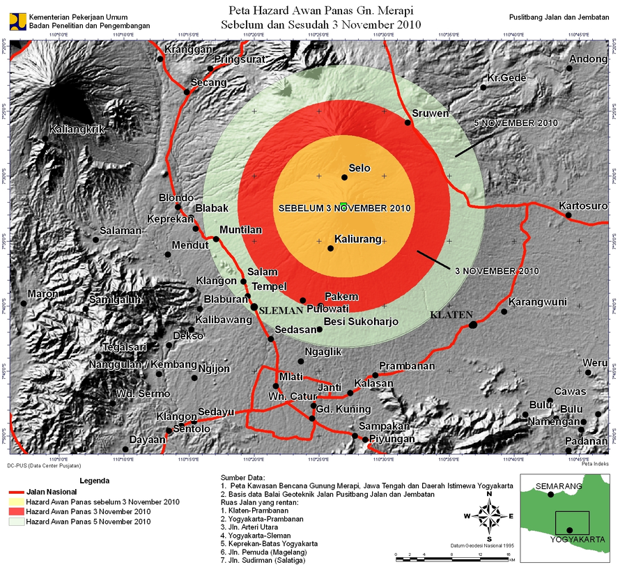
Official, Unknown format
Peta Hazard Awan Panas Gn. Merapi Sebelum dan Sesudah 3 November 2010
(Pyroclastic Flow Hazard Map Mt. Merapi Before and After 3 November 2010)
Kementerian Pekerjaan Umum, Badan Penelitian dan Pengembangan, Puslitbang Jalan dan Jembatan. (2010). Peta Hazard Awan Panas Gn. Merapi Sebelum dan Sesudah 3 November 2010.