
Advanced Search for Maps
Showing 1-10 of 16
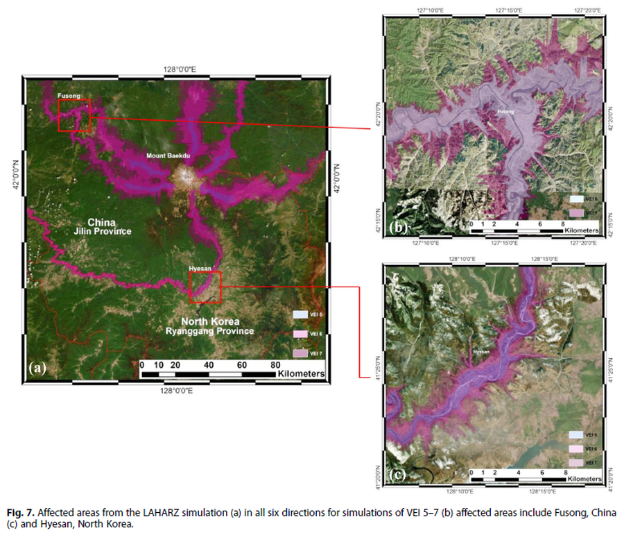
Figure in a journal article
Affected areas from the LAHARZ simulation
Figure 7 in: Achmad, A.R., Lee, S., Park, S. Eom, J., & Lee, C.-W. (2020). Estimating the potential risk of the Mt. Baekdu Volcano using a synthetic interferogram and the LAHARZ inundation zone. Geosciences Journal. 24, 755–768. https://doi.org/10.1007/s12303-020-0032-9
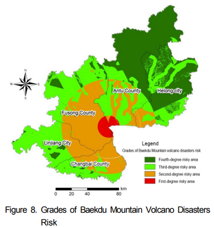
Figure in a journal article
Grades of Baekdu Mountain Volcano Disasters Risk
Figure 8 in: Xiao-Jiao, N., Choi, Y. S., & Ying, N. (2014). A Study on Integrated Assessment of Baekdu Mountain Volcanic Aisaster risk Based on GIS. Journal of Korea Spatial Information Society. Korea Spatial Information Society. https://doi.org/10.12672/ksis.2014.22.4.077
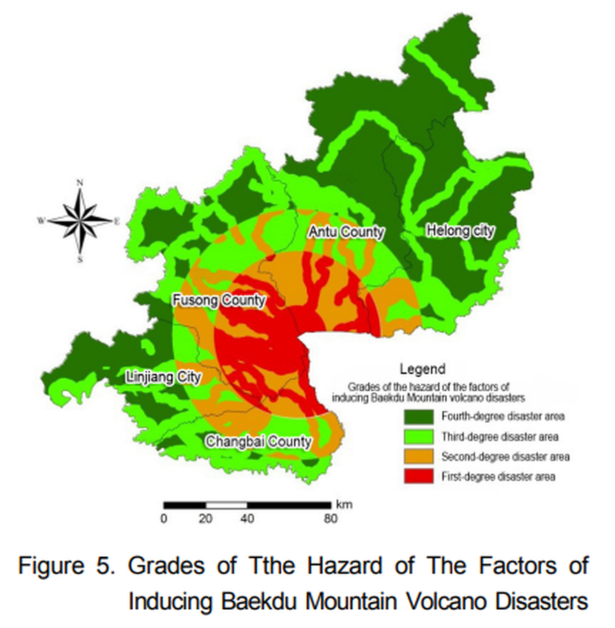
Figure in a journal article
Grades of Tthe Hazard of The Factors of Inducing Baekdu Mountain Volcano Disasters
Figure 5 in: Xiao-Jiao, N., Choi, Y. S., & Ying, N. (2014). A Study on Integrated Assessment of Baekdu Mountain Volcanic Aisaster risk Based on GIS. Journal of Korea Spatial Information Society. Korea Spatial Information Society. https://doi.org/10.12672/ksis.2014.22.4.077
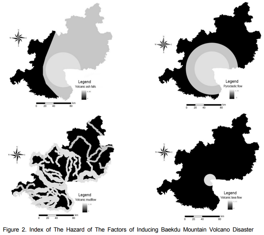
Figure in a journal article
Index of The Hazard of The Factors of Inducing Baekdu Mountain Volcano Disaster
Figure 2 in: Xiao-Jiao, N., Choi, Y. S., & Ying, N. (2014). A Study on Integrated Assessment of Baekdu Mountain Volcanic Aisaster risk Based on GIS. Journal of Korea Spatial Information Society. Korea Spatial Information Society. https://doi.org/10.12672/ksis.2014.22.4.077
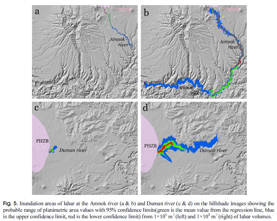
Figure in a journal article
Inundation areas of lahar at the Amnok river and Duman river
Figure 5 in: Yun, S. H. & Chang, C. (2017). Prediction of Lahar Flow Inundation Areas Using LAHARZ_py Program: Application for the Mt. Baekdu Volcano. Economic and Environmental Geology, 50(4), 277-286. https://doi.org/10.9719/EEG.2017.50.4.277
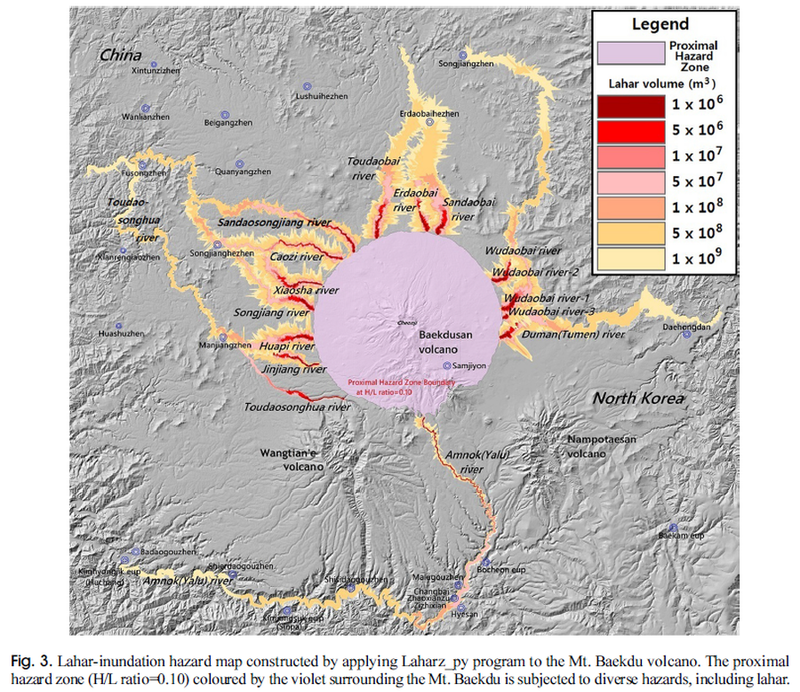
Figure in a journal article
Lahar-inundation hazard map constructed by applying Laharz_py program to the Mt. Baekdu volcano
Figure 3 in: Yun, S. H. & Chang, C. (2017). Prediction of Lahar Flow Inundation Areas Using LAHARZ_py Program: Application for the Mt. Baekdu Volcano. Economic and Environmental Geology, 50(4), 277-286. https://doi.org/10.9719/EEG.2017.50.4.277
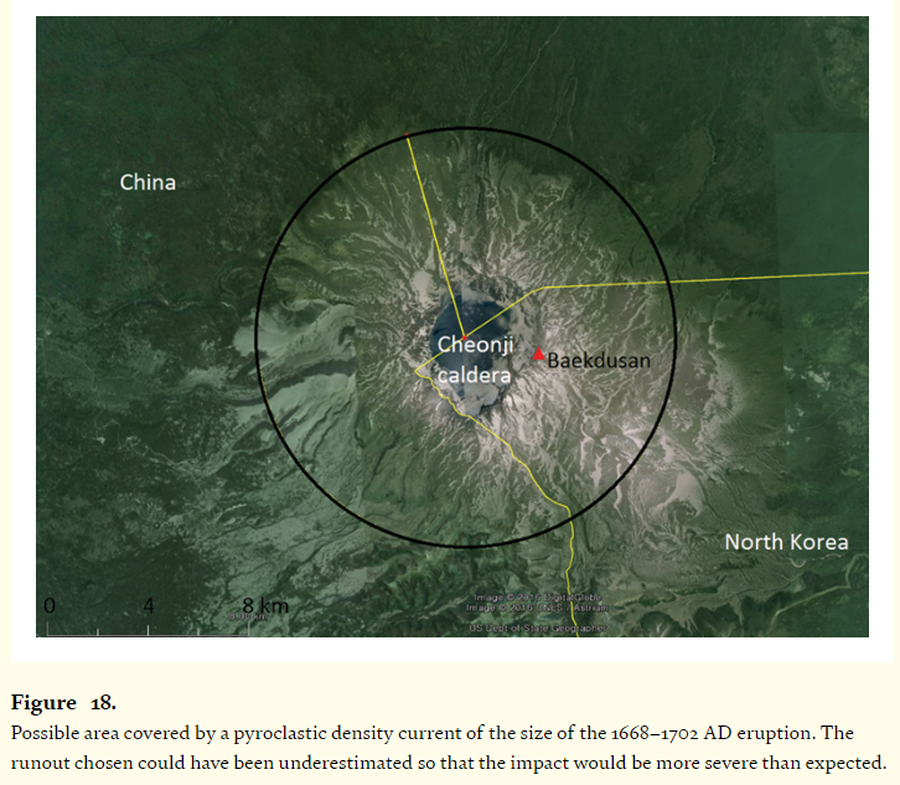
Figure in a journal article
Possible area covered by a pyroclastic density current of the size of the 1668–1702 AD eruption.
Figure 18 in: Paone, A., & Yun, S. H. (2016). Pyroclastic density current hazards at the Baekdusan volcano, Korea: analyses of several scenarios from a small-case to the worst-case colossal eruption. In: Németh, K. (Ed.) Updates in Volcanology-From Volcano Modelling to Volcano Geology. IntechOpen. https://doi.org/10.5772/62340
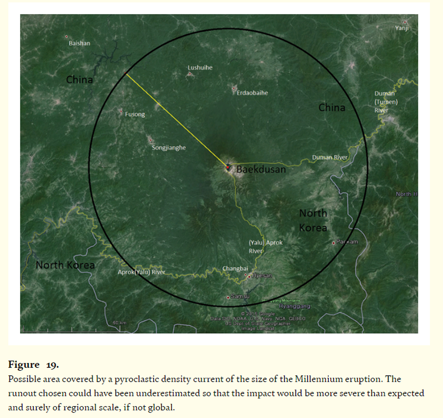
Figure in a journal article
Possible area covered by a pyroclastic density current of the size of the Millennium eruption
Figure 19 in: Paone, A., & Yun, S. H. (2016). Pyroclastic density current hazards at the Baekdusan volcano, Korea: analyses of several scenarios from a small-case to the worst-case colossal eruption. In: Németh, K. (Ed.) Updates in Volcanology-From Volcano Modelling to Volcano Geology. IntechOpen. https://doi.org/10.5772/62340
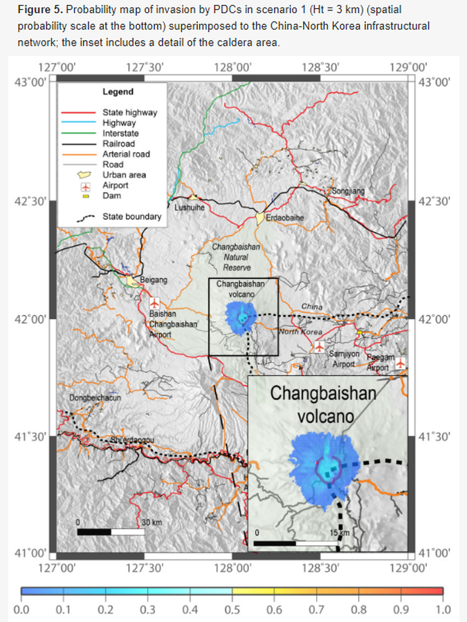
Figure in a journal article
Probability map of invasion by PDCs in scenario 1
Figure 5 in: Lombardi AM, Del Gaudio P, Guo Z, Zhang M, Liu G, Sepe V, Liu J, Ventura G. (2020). Scenario-Based Pyroclastic Density Current Invasion Maps at Poorly Known Volcanoes: A Case Study from Changbaishan (China/North Korea). Applied Sciences, 10(7), 2622. https://doi.org/10.3390/app10072622
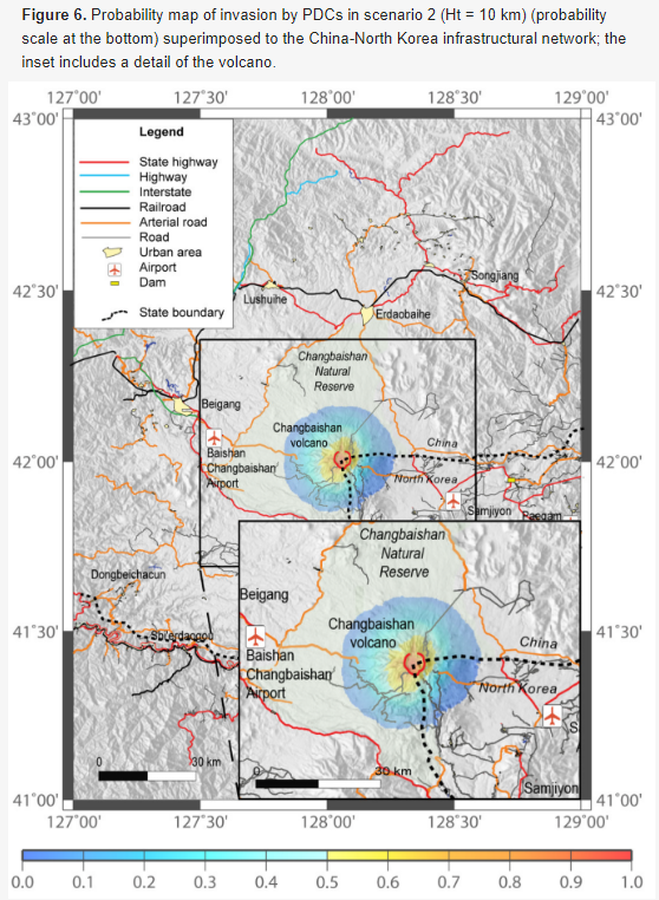
Figure in a journal article
Probability map of invasion by PDCs in scenario 2
Figure 6 in: Lombardi AM, Del Gaudio P, Guo Z, Zhang M, Liu G, Sepe V, Liu J, Ventura G. (2020). Scenario-Based Pyroclastic Density Current Invasion Maps at Poorly Known Volcanoes: A Case Study from Changbaishan (China/North Korea). Applied Sciences, 10(7), 2622. https://doi.org/10.3390/app10072622
Page: 1 2