
Advanced Search for Maps
Showing 1-10 of 19
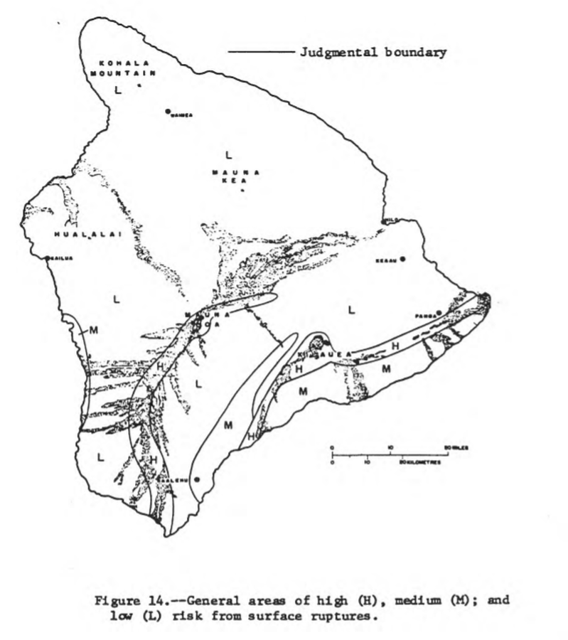
Official, Figure in hazard assessment
General areas of high (H), medium (M), and low (L) risk from surface ruptures
Figure 14 in: Mullineaux, D.R. & Peterson, D.W. (1974). Volcanic hazards on the Island of Hawaii. U.S. Geological Survey, Open-File Report 74-239. https://doi.org/10.3133/ofr74239
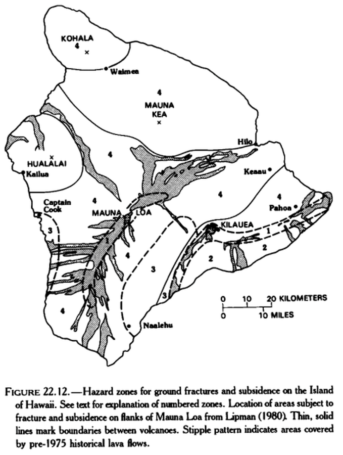
Official, Figure in hazard assessment
Hazard zones for ground fractures and subsidence on the Island of Hawaii
Figure 22.12 in: Mullineaux, D.R., Peterson, D.W., & Crandell, D.R. (1987). Volcanic hazards in the Hawaiian Islands. In: Decker, R.W., Wright, T.L., & Stauffer, P.H. (Eds.) Volcanism in Hawaii. US Geological Survey Professional Paper 1350, Chapter 22, p. 599-621. https://doi.org/10.3133/pp1350
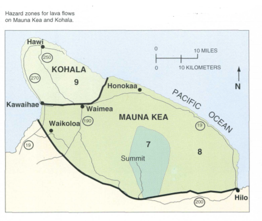
Official, Map in a booklet, long fact-sheet, or handbook
Hazard zones for lava flows on Mauna Kea and Kohala
Page 32 in: U.S. Geological Survey (USGS). (1997). Volcanic and Seismic Hazards on the Island of Hawaii. U.S. Geological Survey, Unumbered Series, 48 p. https://doi.org/10.3133/7000036 (Simplified from: Wright 1992)
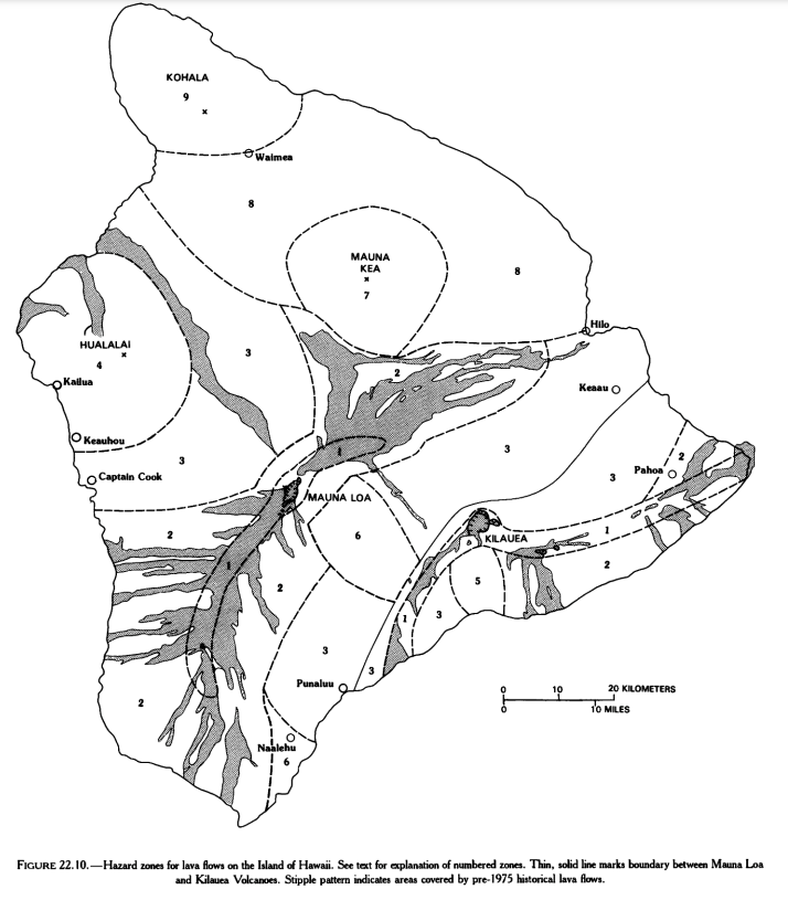
Official, Figure in hazard assessment
Hazard zones for lava flows on the Island of Hawaii
Figure 22.10 in: Mullineaux, D.R., Peterson, D.W., & Crandell, D.R. (1987). Volcanic hazards in the Hawaiian Islands. In: Decker, R.W., Wright, T.L., & Stauffer, P.H. (Eds.) Volcanism in Hawaii. US Geological Survey Professional Paper 1350, Chapter 22, p. 599-621. https://doi.org/10.3133/pp1350
Official, Figure in hazard assessment
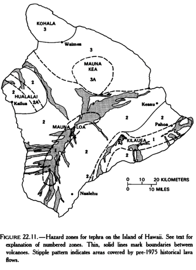
Hazard zones for tephra on the Island of Hawaii
Figure 22.11 in: Mullineaux, D.R., Peterson, D.W., & Crandell, D.R. (1987). Volcanic hazards in the Hawaiian Islands. In: Decker, R.W., Wright, T.L., & Stauffer, P.H. (Eds.) Volcanism in Hawaii. US Geological Survey Professional Paper 1350, Chapter 22, p. 599-621. https://doi.org/10.3133/pp1350
Official, Unknown format
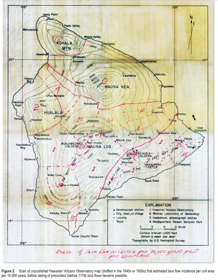
Index of lava flow incidence per 10,000 years past per square mile
Figure 2 (in reprint) in: Hawaiian Volcano Observatory. (1940s or 1950s). Index of lava flow incidence per 10,000 years past per square mile. (Reprinted in: Kauahikaua, J.P. & Tilling, R.I. (2014). Natural hazards and risk reduction in Hawai‘i. In: Poland, M.P., Takahashi, T.J., & Landowski, C.M. (eds.) Characteristics of Hawaiian Volcanoes. US Geological Survey Professional Paper 1801, p. 397-427. https://doi.org/10.3133/pp180110)
Official, Figure in hazard assessment
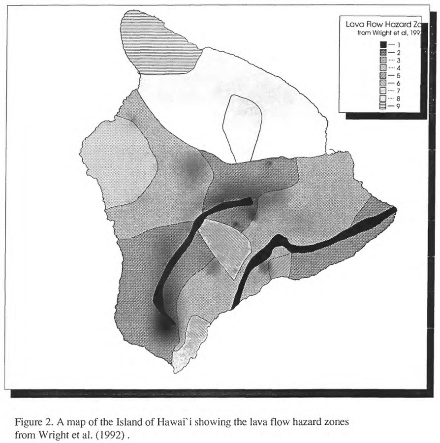
Lava Flow Hazard Zones
Figure 2 in: Kauahikaua, J. P., Moore, R. B., & Delaney, P. (1994). Volcanic activity and ground deformation hazard analysis for the Hawaii geothermal project environmental impact statement. US Geological Survey, Open File Report 94-553. 44 p. https://doi.org/10.3133/ofr94553 (Modified from: Wright et al. 1992)
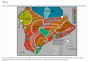
Figure in a journal article
Lava flow inundation hazard zones for Hawai‘i shown with colors indicating increasing hazard (adapted from Heliker 1990; Wright et al. 1992). Superimposed on hazard zones are channel-length contours from Fig. 4 (dashed color lines).
Figure 5 in: Rowland, S. K., Garbeil, H., & Harris, A. J. (2005). Lengths and hazards from channel-fed lava flows on Mauna Loa, Hawai ‘i, determined from thermal and downslope modeling with FLOWGO. Bulletin of Volcanology, 67(7), 634-647. https://doi.org/10.1007/s00445-004-0399-x
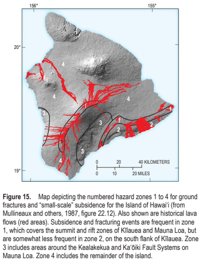
Official, Figure in a journal article
Map depicting the numbered hazard zones 1 to 4 for ground fractures and “small-scale” subsidence for the Island of Hawai‘i
Figure 15 in: Kauahikaua, J.P. & Tilling, R.I. (2014). Natural hazards and risk reduction in Hawai‘i. In: Poland, M.P., Takahashi, T.J., & Landowski, C.M. (eds.) Characteristics of Hawaiian Volcanoes. US Geological Survey Professional Paper 1801, p. 397-427. https://doi.org/10.3133/pp180110
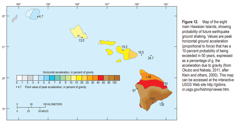
Official, Figure in a journal article
Map of the eight main Hawaiian Islands, showing probability of future earthquake ground shaking
Figure 12 in: Kauahikaua, J.P. & Tilling, R.I. (2014). Natural hazards and risk reduction in Hawai‘i. In: Poland, M.P., Takahashi, T.J., & Landowski, C.M. (eds.) Characteristics of Hawaiian Volcanoes. US Geological Survey Professional Paper 1801, p. 397-427. https://doi.org/10.3133/pp180110
Page: 1 2