
Advanced Search for Maps
Showing 1-10 of 19
Official, Interactive web-based map
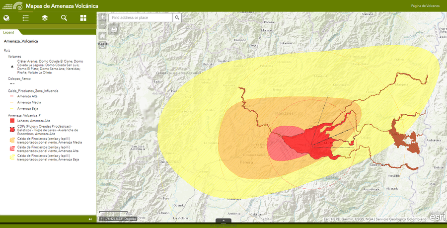
Amenaza Ruiz
(Ruiz Hazards)
Servicio Geológico Colombiano (SGC). Amenaza Ruiz.
Unknown format
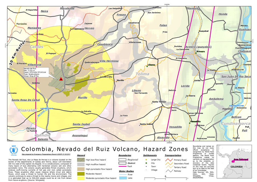
Colombia, Nevado del Ruiz Volcano, Hazard Zones
World Food Programme. (2012). Colombia, Nevado del Ruiz Volcano, Hazard Zones. World Food Programme, Emergency Preparedness Branch (ODEP)
Official (foreign agency), Figure on website
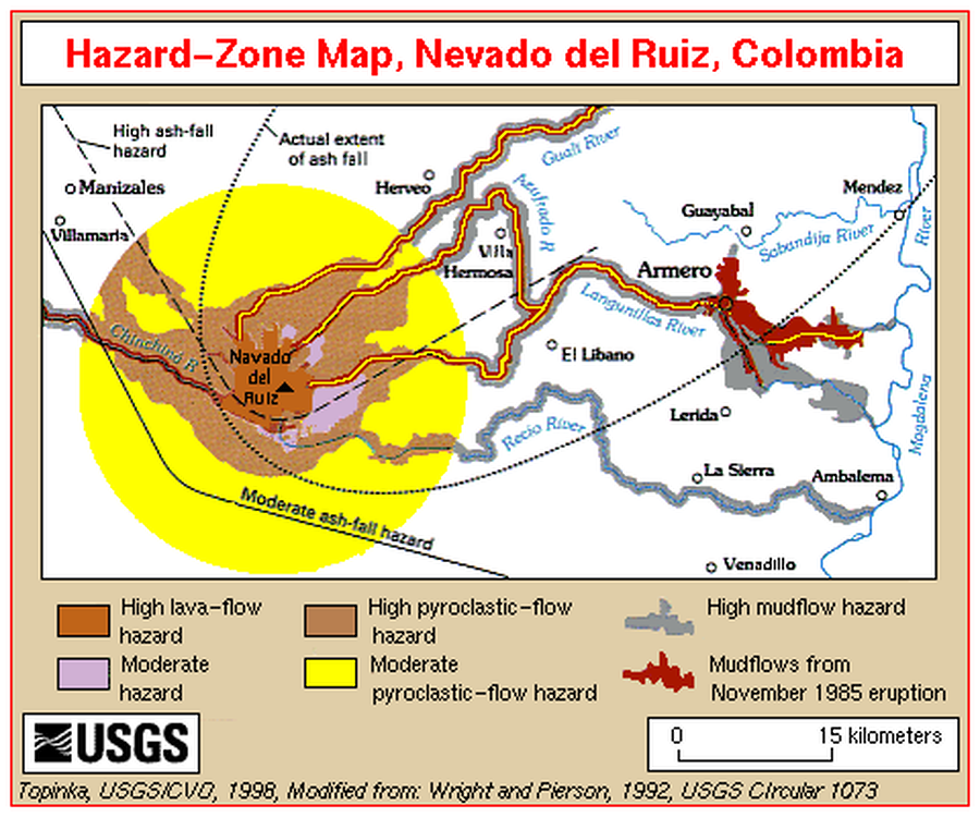
Hazard-Zone Map, Nevado del Ruiz, Colombia
Topinka, L. (1998). Hazard-Zone Map, Nevado del Ruiz, Colombia. U.S. Geological Survey. http://vulcan.wr.usgs.gov/Imgs/Gif/Ruiz/Maps/map_ruiz_hazard_zones.gif (Modified from: Wright et al. 1992)
Official, Figure in a journal article
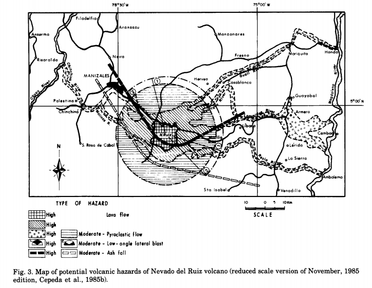
Map of potential volcanic hazards of Nevado del Ruiz volcano (reduced scale version of November, 1985 edition)
Figure 3 in: Parra, E. & Cepeda, H. (1990). Volcanic hazard maps of the Nevado del Ruiz volcano, Colombia. Journal of Volcanology and Geothermal Research, 42, p. 177-127. https://doi.org/10.1016/0377-0273(90)90073-O (Modified from: Cepeda et al. 1985)
Official, Figure in a journal article
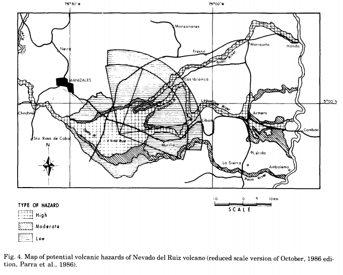
Map of potential volcanic hazards of Nevado del Ruiz volcano (reduced scale version of October, 1986 edition)
Figure 4 in: Parra, E. & Cepeda, H. (1990). Volcanic hazard maps of the Nevado del Ruiz volcano, Colombia. Journal of Volcanology and Geothermal Research, 42, p. 177-127. https://doi.org/10.1016/0377-0273(90)90073-O (Modified from: Parra et al. 1986)
Official, Figure in a journal article
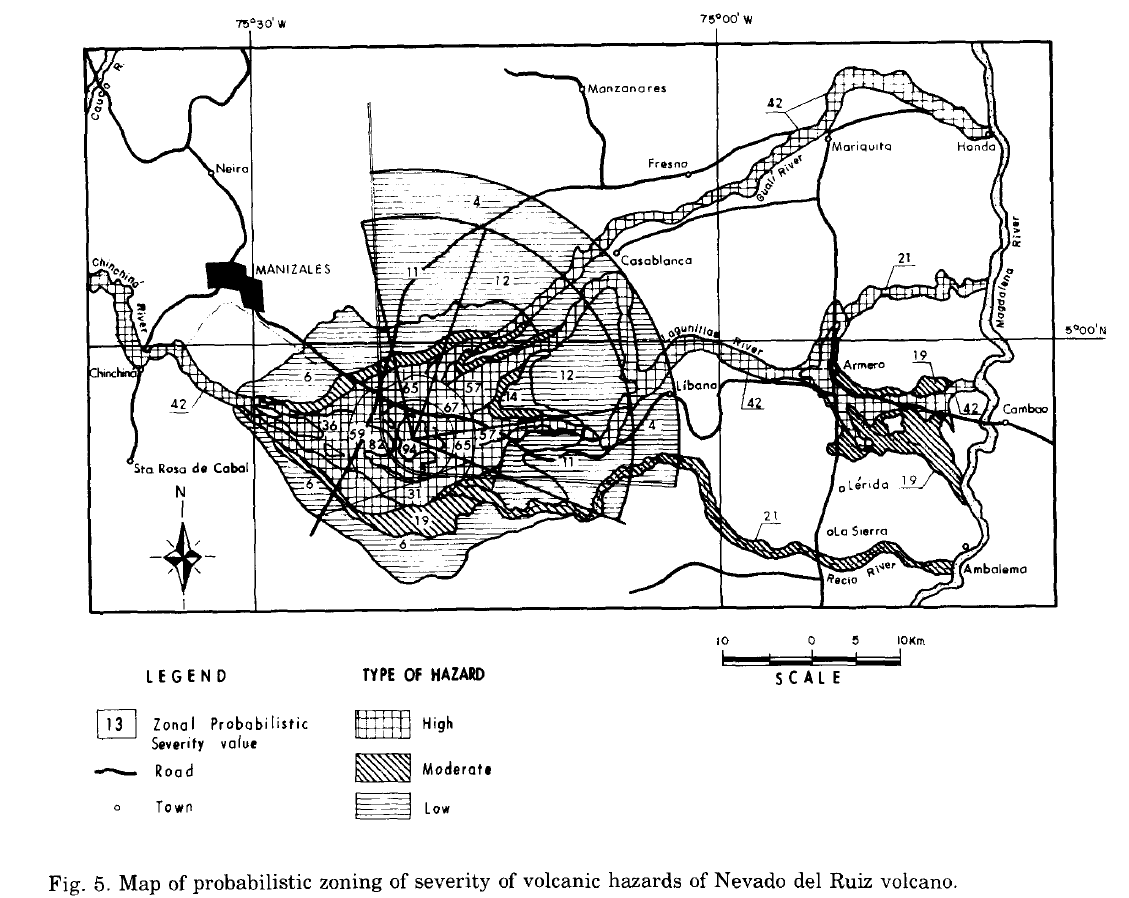
Map of probabilistic zoning of severity of volcanic hazards of Nevado del Ruiz volcano
Figure 5 in: Parra, E. & Cepeda, H. (1990). Volcanic hazard maps of the Nevado del Ruiz volcano, Colombia. Journal of Volcanology and Geothermal Research, 42, p. 177-127. https://doi.org/10.1016/0377-0273(90)90073-O
Official (foreign agency), Figure in hazard assessment
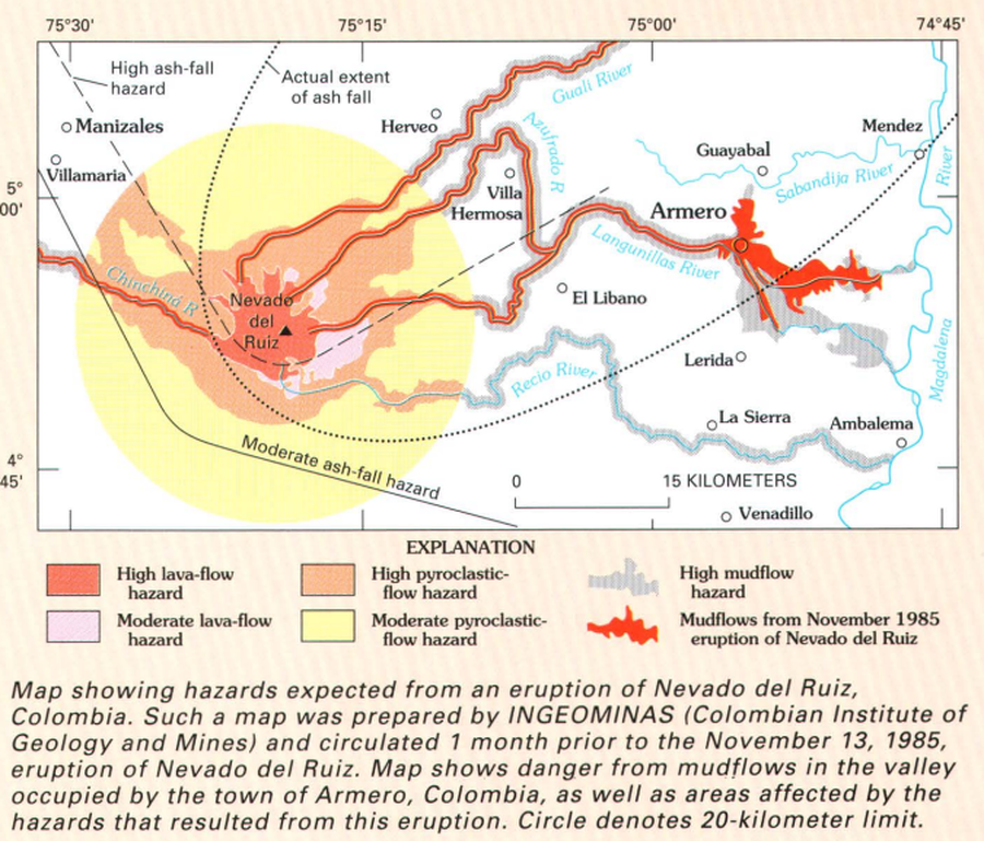
Map showing hazards expected from an eruption of Nevado del Ruiz, Colombia
Page 21 in: Wright, T. L., & Pierson, T. C. (1992). Living with volcanoes. US Geological Survey, Circular 1073. https://doi.org/10.3133/cir1073
Official, Map sheet or poster
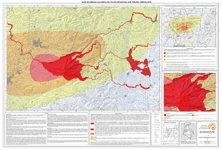
Mapa de Amenaza Volcánica del Volcán Nevado del Ruiz, Tercera Versión (2015)
(Volcanic Hazard Map of Nevado del Ruiz Volcano, Third Version (2015))
Servicio Geológico Colombiano (SGC). (2015). Mapa de Amenaza Volcánica del Volcán Nevado del Ruiz, Tercera Version. mapa escala 1:120,000. Bogota.
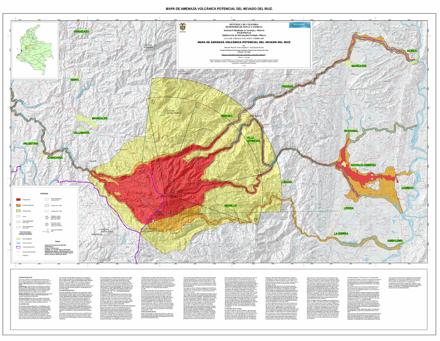
Official, Map sheet or poster
Mapa de Amenaza Volcánica Potencial del Nevado del Ruiz
(Potential Volcanic Hazard Map of the Nevado del Ruiz)
Parra, E., Cepeda, H., Thouret, J. C. (2007). Mapa de Amenaza Volcanica del Nevado del Ruiz. Instituto Colombiano de Geologia y Mineria, mapa escala 1:100,000. Bogota.
Official, Map sheet or poster
Mapa de Amenaza Volcanica Potencial del Nevado del Ruiz (Octubre 7 de 1986)
(Nevado del Ruiz Potential Volcanic Threat Map (October 7, 1986))
Parra, E., Cepeda, H. & Thouret, J. C. (1986). Mapa de Amenaza Volcanica Potencial del Nevado del Ruiz (Octubre 7 de 1986). Esc. 1:100,000. Instituto Colombiano de Geología y Minería (INGEOMINAS). Bogota.
Page: 1 2