
Advanced Search for Maps
Showing 1-10 of 45
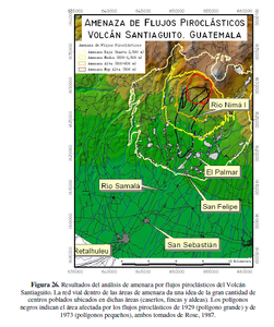
Official, Figure in hazard assessment
Amenaza de Flujos Piroclásticos Volcán Santiaguito, Guatemala
(Threat of Pyroclastic Flows Santiaguito Volcano, Guatemala)
Figure 26 in: UNESCO, Instituto Nacional de Sismología, Vulcanología, Meteorología e Hidrología (INSIVUMEH), Coordinadora Nacional para la Reducción de Desastres (CONRED), Instituto Geográfico Nacional (IGN), Facultad de Agronomía (FAUSAC), Universidad de San Carlos de Guatemala Centro de Estudios Superiores de Energía y Minas (CESEM), Universidad de San Carlos de Guatemala, Escuela Regional de Ingeniería Sanitaria (ERIS). (2003). Zonificación de Amenazas Naturales en la cuenca del río Samalá y Análisis de vulnerabilidad y riesgo en la población de San Sebastián Retalhuleu, Guatemala, Centro América. Capacity Building for Natural Disaster Reduction (CBNDR) Regional Action Program for Central America (RAPCA). Guatemala, Septiembre 2003.
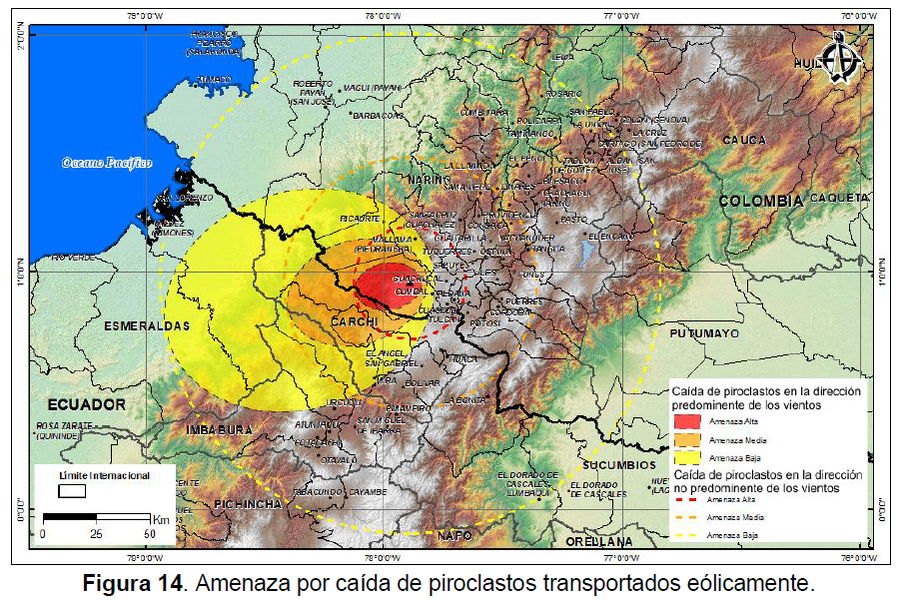
Official, Figure in hazard assessment
Amenaza por caída de piroclastos transportados eólicamente
(Hazard from falling wind-borne pyroclasts)
Figure 14 in: Méndez, R., Narváez, P., Muñoz, C. (2014). Mapa de Amenaza Volcánica del Complejo Volcánico Cumbal -- Segunda Versión. Memoria Explicativa. San Juan de Pasto: Servicio Geológico Colombiano.
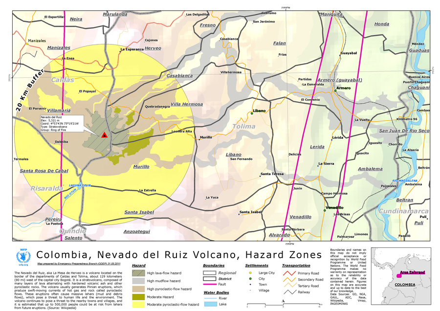
Unknown format
Colombia, Nevado del Ruiz Volcano, Hazard Zones
World Food Programme. (2012). Colombia, Nevado del Ruiz Volcano, Hazard Zones. World Food Programme, Emergency Preparedness Branch (ODEP)
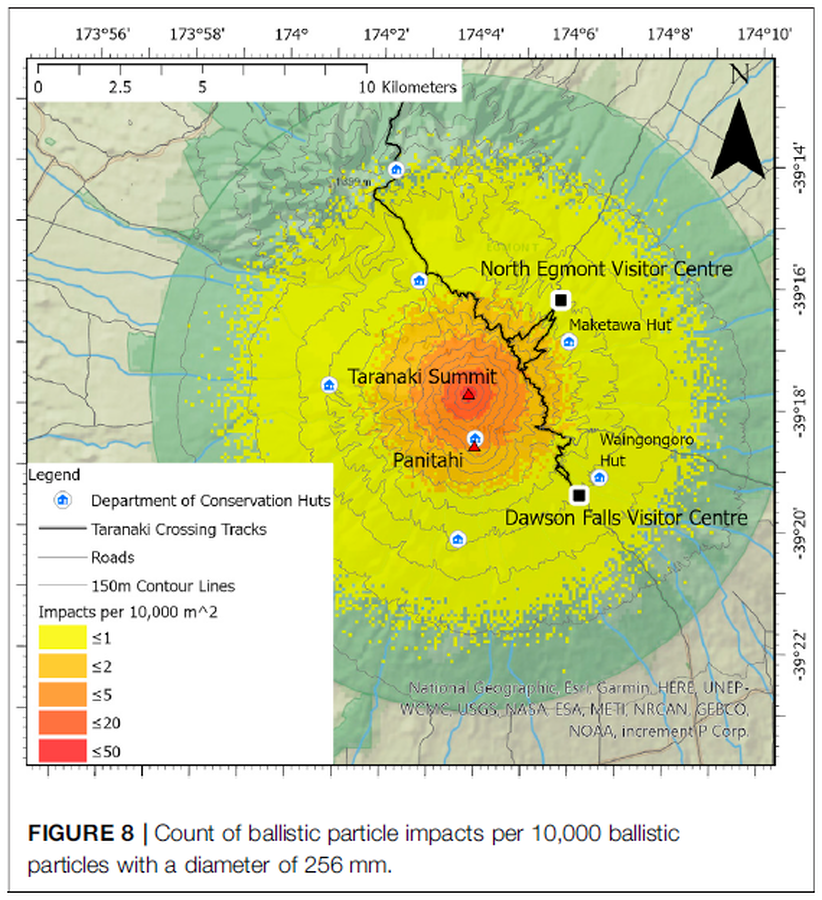
Figure in a journal article
Count of ballistic particle impacts per 10,000 ballistic particles with a diameter of 256 mm
Figure 8 in: Mead, S., Procter, J., Bebbington, M., & Rodriguez-Gomez, C. (2022). Probabilistic Volcanic Hazard Assessment for National Park Infrastructure Proximal to Taranaki Volcano (New Zealand). Frontiers in Earth Science, 435. https://doi.org/10.3389/feart.2022.832531

Figure in a journal article
Delineation of impact areas for three VBP diameters ejected during the scenario of a hydrothermal eruption at the Hsiaoyiokeng fumarole
Figure 6 in: Nurmawati, A., & Konstantinou, K. I. (2018). Hazard assessment of volcanic ballistic impacts at Mt Chihshin, Tatun Volcano Group, northern Taiwan. Natural hazards, 92(1), p. 77-92. https://doi.org/10.1007/s11069-018-3192-4
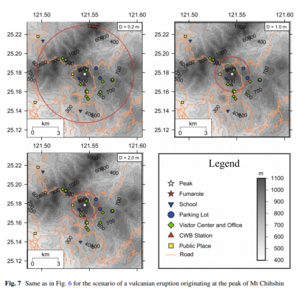
Figure in a journal article
Delineation of impact areas for three VBP diameters ejected during the scenario of a vulcanian eruption originating at the peak of Mt Chihshin
Figure 7 in: Nurmawati, A., & Konstantinou, K. I. (2018). Hazard assessment of volcanic ballistic impacts at Mt Chihshin, Tatun Volcano Group, northern Taiwan. Natural hazards, 92(1), p. 77-92. https://doi.org/10.1007/s11069-018-3192-4
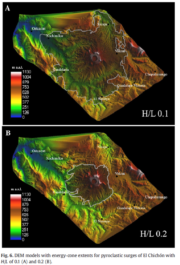
Figure in a journal article
DEM models with energy-cone extents for pyroclastic surges of El Chichón with H/L of 0.1 (A) and 0.2 (B).
Figure 6 in: Macías, J. L., Capra, L., Arce, J. L., Espíndola, J. M., García-Palomo, A., & Sheridan, M. F. (2008). Hazard map of El Chichón volcano, Chiapas, México: Constraints posed by eruptive history and computer simulations. Journal of Volcanology and Geothermal Research, 175(4), 444-458. https://doi.org/10.1016/j.jvolgeores.2008.02.023
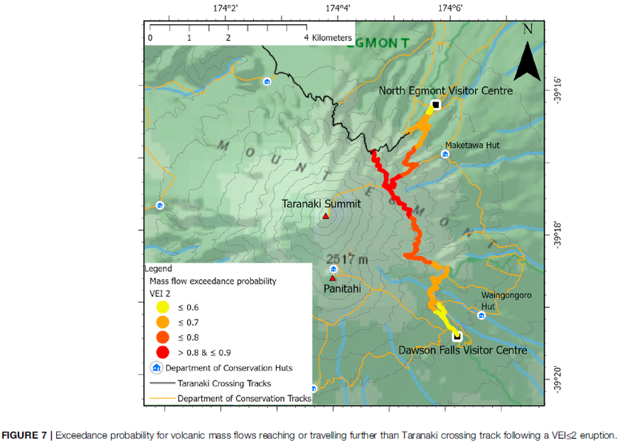
Figure in a journal article
Exceedance probability for volcanic mass flows reaching or travelling further than Taranaki crossing track following a VEI≤2 eruption
Figure 7 in: Mead, S., Procter, J., Bebbington, M., & Rodriguez-Gomez, C. (2022). Probabilistic Volcanic Hazard Assessment for National Park Infrastructure Proximal to Taranaki Volcano (New Zealand). Frontiers in Earth Science, 435. https://doi.org/10.3389/feart.2022.832531
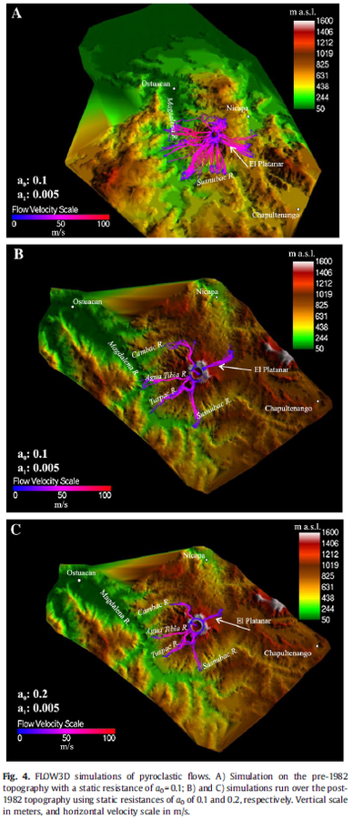
Figure in a journal article
FLOW3D simulations of pyroclastic flows
Figure 4 in: Macías, J. L., Capra, L., Arce, J. L., Espíndola, J. M., García-Palomo, A., & Sheridan, M. F. (2008). Hazard map of El Chichón volcano, Chiapas, México: Constraints posed by eruptive history and computer simulations. Journal of Volcanology and Geothermal Research, 175(4), 444-458. https://doi.org/10.1016/j.jvolgeores.2008.02.023
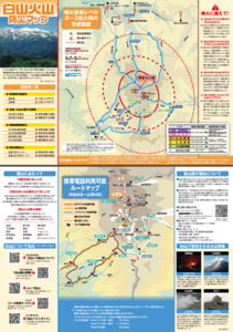
Official, Hiking or trail map
Hakusan Volcanic Disaster Prevention Map
Ishikawa Prefecture. (2019). Hakusan Volcanic Disaster Prevention Map.