
Advanced Search for Maps
Showing 1-10 of 28
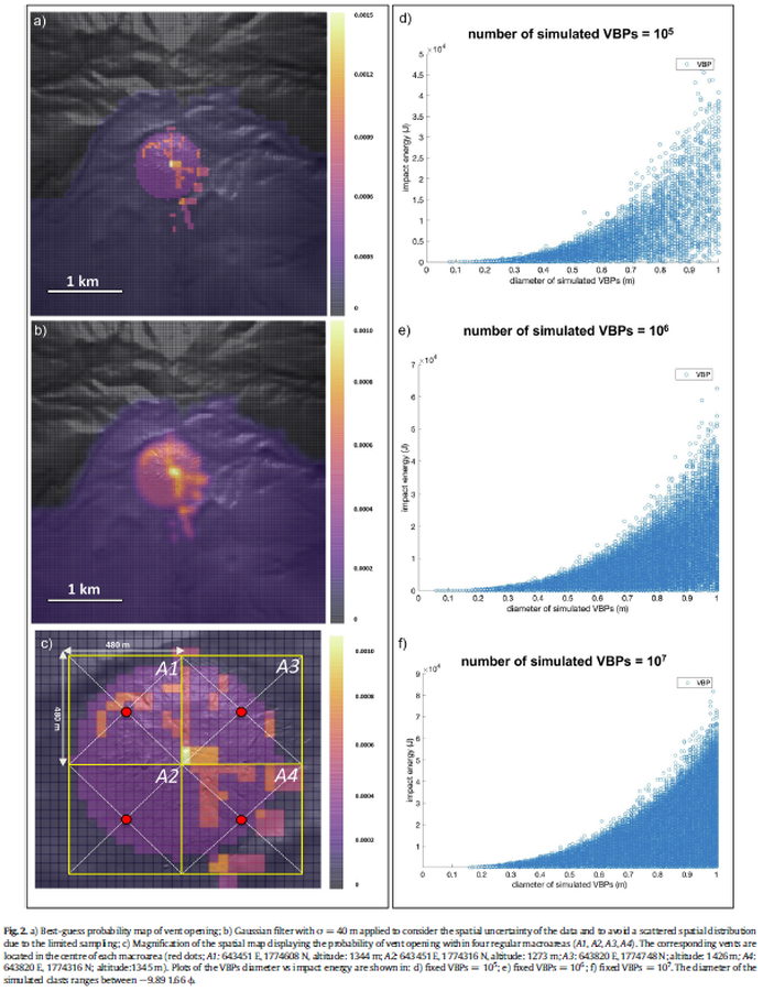
Figure in a journal article
Best-guess probability map of vent opening
Figure 2 in: Massaro, S., Rossi, E., Sandri, L., Bonadonna, C., Selva, J., Moretti, R., & Komorowski, J. C. (2022). Assessing hazard and potential impact associated with volcanic ballistic projectiles: The example of La Soufrière de Guadeloupe volcano (Lesser Antilles). Journal of volcanology and geothermal research, 423, 107453. https://doi.org/10.1016/j.jvolgeores.2021.107453

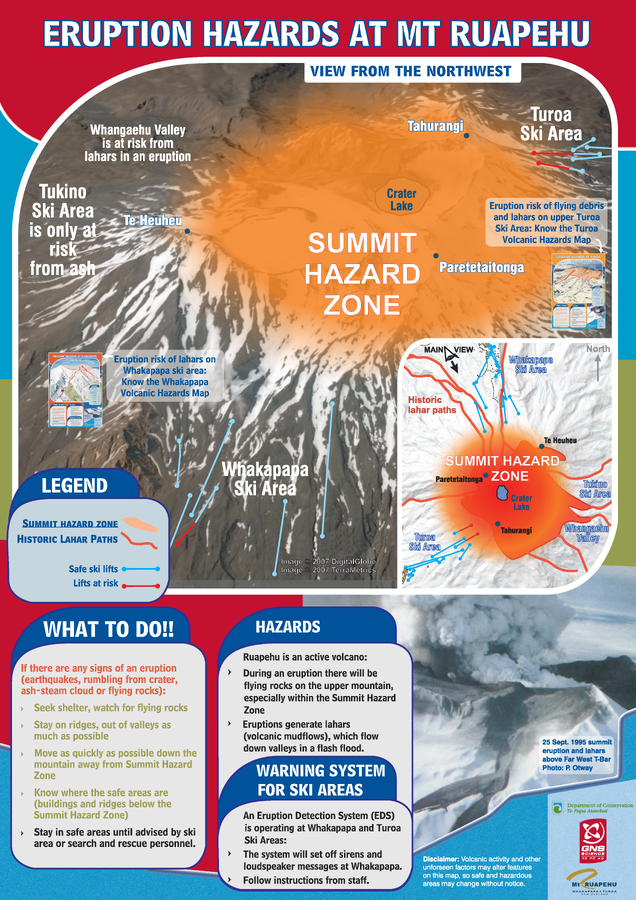
Official, Sign or billboard
Eruption Hazards at Mt. Ruapehu
GNS Science (compiler). (2007). Eruption Hazards at Mt. Ruapehu. 8 October 2007.
Official, Sign or billboard
Eruption Hazards at Mt. Ruapehu
GNS Science (compiler). (2008). Eruption Hazards at Mt. Ruapehu.
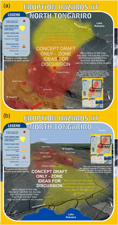
Official, Map sheet or poster
Eruption Hazards at North Tongariro
GNS Science (compiler). (2012). Te Maari Eruption Phenomena. Version 0.1, 6 August 2012. (Reprinted in: Leonard, G. S., Stewart, C., Wilson, T. M., Procter, J. N., Scott, B. J., Keys, H. J., Jolly, G.E., Wardman, J.B., Cronin. S.J. & McBride, S. K. (2014). Integrating multidisciplinary science, modelling and impact data into evolving, syn-event volcanic hazard mapping and communication: a case study from the 2012 Tongariro eruption crisis, New Zealand. Journal of Volcanology and Geothermal Research, 286, p. 208-232. https://doi.org/10.1016/j.jvolgeores.2014.08.018)
Official, Flyer, brochure, short fact-sheet, or handout
Esan Volcanic Alert Levels
Japan Meteorological Agency. (2018). Esan Volcanic Alert Levels. Volcano Monitoring and Warning Center, Volcano Division, Earthquake and Volcano Department.
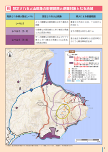
Official, Map in a booklet, long fact-sheet, or handbook
Expected scope of volcanic phenomena and areas targeted for evacuation
Page 4 in: Hakodate City. (2016). Disaster Prevention Handbook of Esan. 12 p.
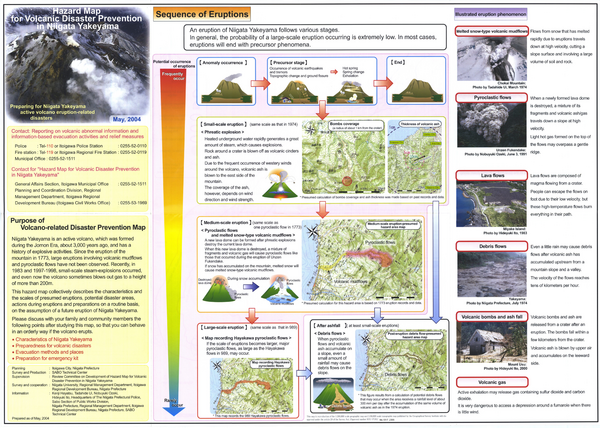
Official, Map sheet or poster
Hazard Map for Volcanic Disaster Prevention in Niigata Yakekama
Niigata Prefecture & Itoigawa City. (2004). Hazard Map for Volcanic Disaster Prevention in Niigata Yakayama.
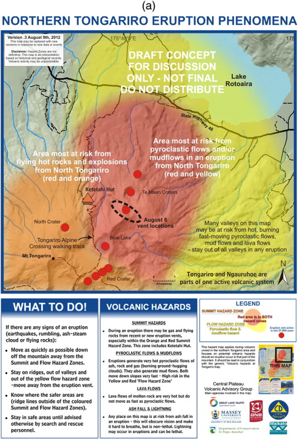
Official, Map sheet or poster
Northern Tongariro Eruption Phenomena
GNS Science (compiler). (2012). Te Maari Eruption Phenomena. Version 0.3, 9 August 2012. (Reprinted in: Leonard, G. S., Stewart, C., Wilson, T. M., Procter, J. N., Scott, B. J., Keys, H. J., Jolly, G.E., Wardman, J.B., Cronin. S.J. & McBride, S. K. (2014). Integrating multidisciplinary science, modelling and impact data into evolving, syn-event volcanic hazard mapping and communication: a case study from the 2012 Tongariro eruption crisis, New Zealand. Journal of Volcanology and Geothermal Research, 286, p. 208-232. https://doi.org/10.1016/j.jvolgeores.2014.08.018)
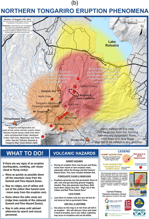
Official, Map sheet or poster
Northern Tongariro Eruption Phenomena
GNS Science (compiler). (2012). Te Maari Eruption Phenomena. Version 1.0, 11 August 2012. (Reprinted in: Leonard, G. S., Stewart, C., Wilson, T. M., Procter, J. N., Scott, B. J., Keys, H. J., Jolly, G.E., Wardman, J.B., Cronin. S.J. & McBride, S. K. (2014). Integrating multidisciplinary science, modelling and impact data into evolving, syn-event volcanic hazard mapping and communication: a case study from the 2012 Tongariro eruption crisis, New Zealand. Journal of Volcanology and Geothermal Research, 286, p. 208-232. https://doi.org/10.1016/j.jvolgeores.2014.08.018)
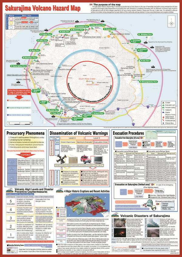
Official, Map sheet or poster
Sakurajima Volcano Hazard Map
Kagoshima City. (2013). Sakurajima Volcano Hazard Map.