
Advanced Search for Maps
Showing 2171-2180 of 2217
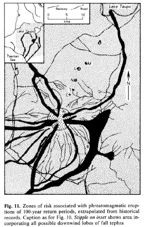
Figure in a journal article
Zones of risk associated with phreatomagmatic eruptions of 100-year return periods, extrapolated from historical records.
Figure 11 in: Houghton, B. F., Latter, J. H., & Hackett, W. R. (1987). Volcanic hazard assessment for Ruapehu composite volcano, Taupo volcanic zone, New Zealand. Bulletin of volcanology, 49(6), p. 737-751. https://doi.org/10.1007/BF01079825
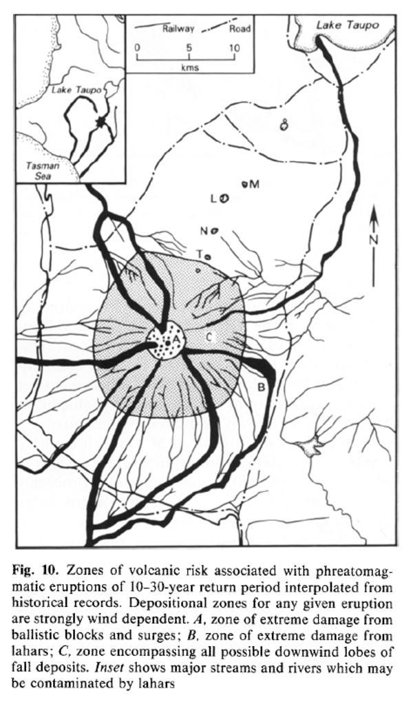
Figure in a journal article
Zones of volcanic risk associated with phreatomagmatic eruptions of 10-30-year return period interpolated from historical records.
Figure 10 in: Houghton, B. F., Latter, J. H., & Hackett, W. R. (1987). Volcanic hazard assessment for Ruapehu composite volcano, Taupo volcanic zone, New Zealand. Bulletin of volcanology, 49(6), p. 737-751. https://doi.org/10.1007/BF01079825

Figure in a journal article
Zones of volcanic risk associated with phreatomagmatic eruptions of return period 1-3 years interpolated from the historical record.
Figure 9 in: Houghton, B. F., Latter, J. H., & Hackett, W. R. (1987). Volcanic hazard assessment for Ruapehu composite volcano, Taupo volcanic zone, New Zealand. Bulletin of volcanology, 49(6), p. 737-751. https://doi.org/10.1007/BF01079825
Official, Figure in hazard assessment
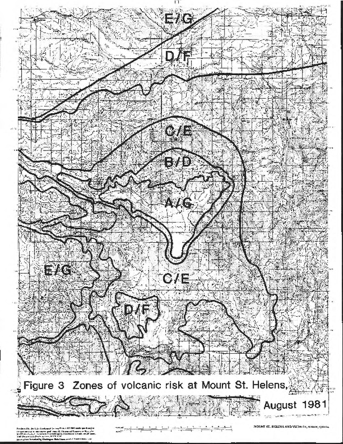
Zones of volcanic risk at Mount St. Helens August 1981
Figure 3 in: Newhall, C.G. (1982). A method for estimating intermediate- and long-term risks from volcanic activity, with an example from Mount St. Helens, Washington. U.S. Geological Survey, Open-File Report 82-396, 59 p. doi: 10.3133/ofr82396
Official, Figure in hazard assessment
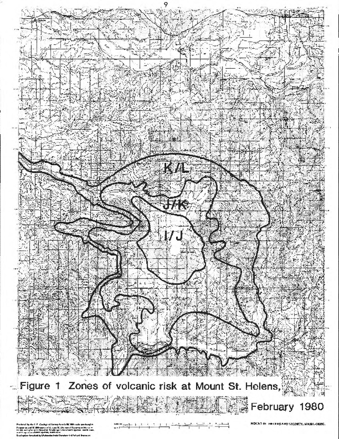
Zones of volcanic risk at Mount St. Helens February 1980
Figure 1 in: Newhall, C.G. (1982). A method for estimating intermediate- and long-term risks from volcanic activity, with an example from Mount St. Helens, Washington. U.S. Geological Survey, Open-File Report 82-396, 59 p. doi: 10.3133/ofr82396
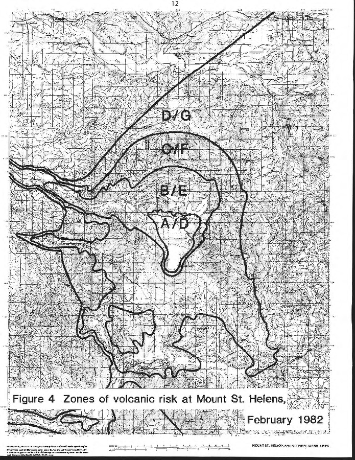
Official, Figure in hazard assessment
Zones of volcanic risk at Mount St. Helens February 1982
Figure 4 in: Newhall, C.G. (1982). A method for estimating intermediate- and long-term risks from volcanic activity, with an example from Mount St. Helens, Washington. U.S. Geological Survey, Open-File Report 82-396, 59 p. doi: 10.3133/ofr82396
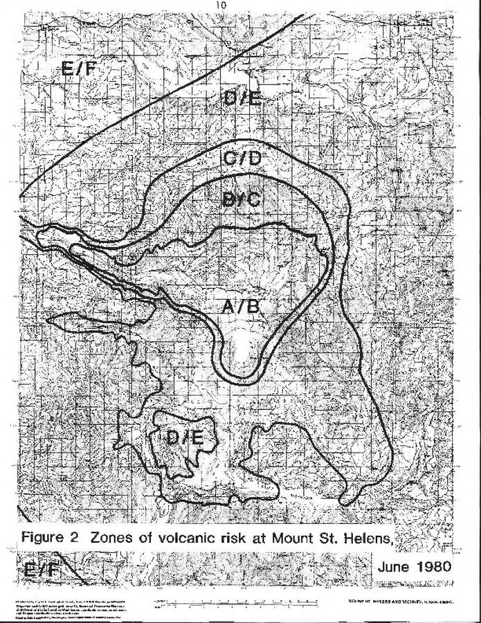
Official, Figure in hazard assessment
Zones of volcanic risk at Mount St. Helens June 1980
Figure 2 in: Newhall, C.G. (1982). A method for estimating intermediate- and long-term risks from volcanic activity, with an example from Mount St. Helens, Washington. U.S. Geological Survey, Open-File Report 82-396, 59 p. doi: 10.3133/ofr82396
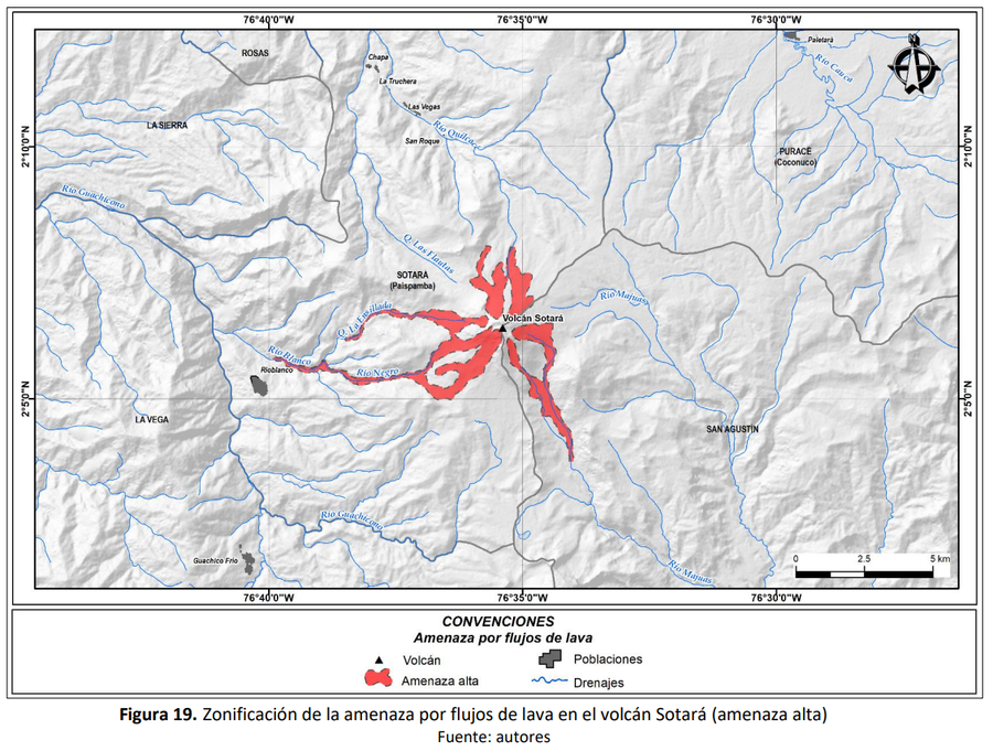
Official, Figure in hazard assessment
Zonificación de la amenaza por flujos de lava en el volcán Sotará (amenaza alta)
(Zoning of the lava flow hazard of Sotará volcano (high hazard))
Figure 19 in: Pulgarín, B., Zuluaga, I., Galarza, J. Muñoz, C. y Laverde, C. (2019). Memoria del mapa de amenaza volcánica del volcán Sotará. Popayán, Pasto y Bogotá: Servicio Geológico Colombiano.
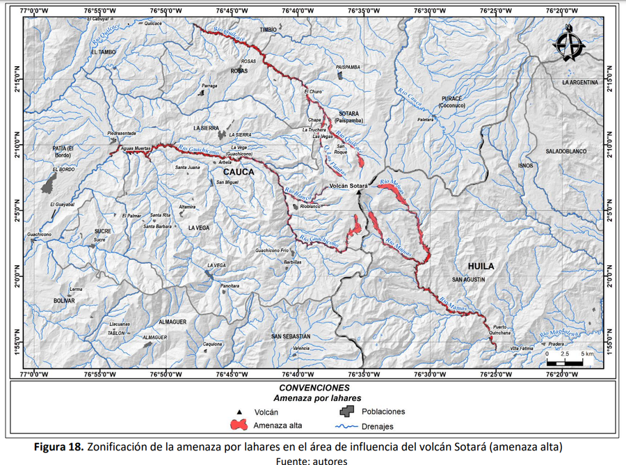
Official, Figure in hazard assessment
Zonificación de la amenaza por lahares en el área de influencia del volcán Sotará (amenaza alta)
(Zoning of the lahar hazard in the area of influence of the Sotará volcano (high hazard))
Figure 18 in: Pulgarín, B., Zuluaga, I., Galarza, J. Muñoz, C. y Laverde, C. (2019). Memoria del mapa de amenaza volcánica del volcán Sotará. Popayán, Pasto y Bogotá: Servicio Geológico Colombiano.
Official, Figure in hazard assessment
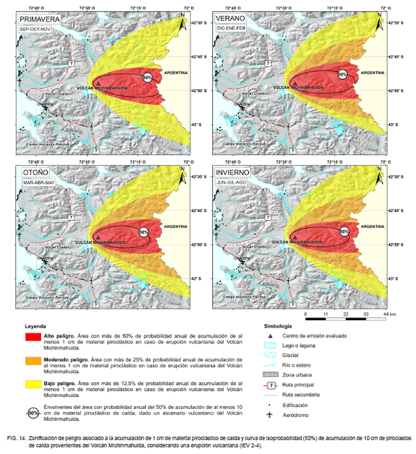
Zonificación de peligro asociado a la acumulación de 1 cm de material piroclástico de caída y curva de isoprobabilidad (50%) de acumulación de 10 cm de piroclastos de caída provenientes del Volcán Michinmahuida, considerando una erupción vulcaniana (IEV 2-4)
(Hazard zoning associated with the accumulation of 1 cm of falling pyroclastic material and isoprobability curve (50%) of accumulation of 10 cm of falling pyroclasts from the Michinmahuida Volcano, considering a volcanic eruption (IEV 2-4))
Figure 14 in: Perales, C., Bono, L., Jorquera, C. (2023). Peligros del Volcán Michinmahuida, región de Los Lagos. Servicio Nacional de Geología y Minería, Carta Geológica de Chile, Serie Geología Am biental 41: 90 p., 1 m apa escala 1:75.000. Santiago.