
Advanced Search for Maps
Showing 11-20 of 25
Official, Map sheet or poster
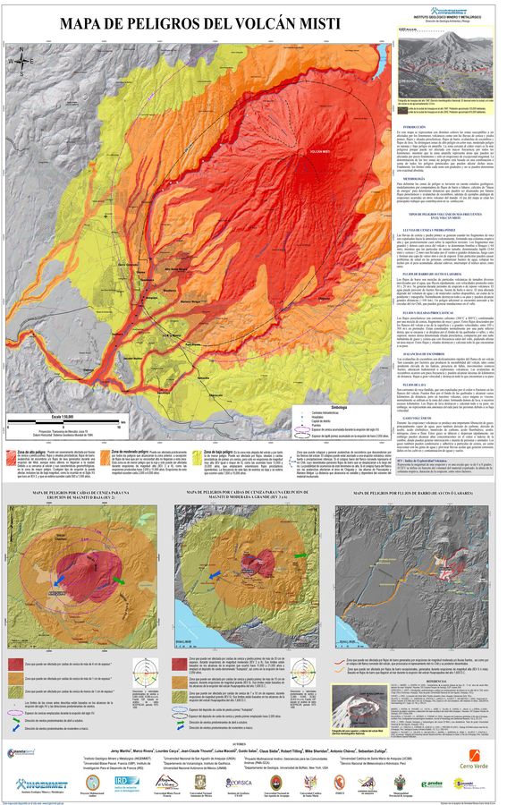
Mapa de Peligros del Volcán Misti
(Misti Volcano Hazards Map)
Mariño, J., Rivera, M., Cacya, L., Thouret, J.-C., Macedo, L., Salas, G., Siebe, C., Tilling, R., Sheridan, M., Chávez, A., & Zuñiga, S. (2007). Mapa de Peligros del Volcán Misti. Instituto Geológico Minero y Metalúrgico (INGEMMET), Direccion de Geologia Ambiental y Riesgo.
Official, Map sheet or poster
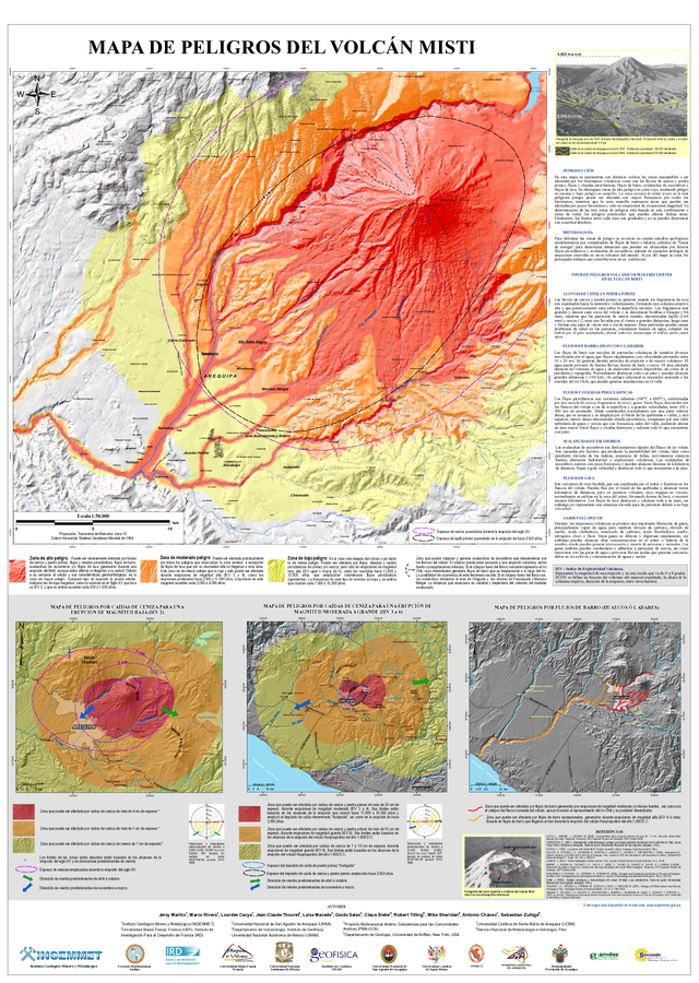
Mapa de Peligros del Volcán Misti
(Misti Volcano Hazards Map)
Mariño, J., Rivera, M., Cacya, L., Thouret, J.-C., Macedo, L., Salas, G., Siebe, C., Tilling, R., Sheridan, M., Chávez, A., & Zuñiga, S. (2014). Mapa de Peligros del Volcán Misti. Instituto Geológico Minero y Metalúrgico (INGEMMET), Direccion de Geologia Ambiental y Riesgo.
Official, Map sheet or poster
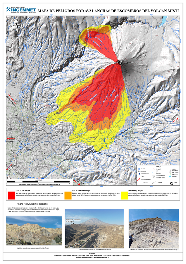
Mapa de Peligros por Avalanchas de Escombros del Volcán Misti
(Map of Hazards from Debris Avalanches of El Misti Volcano)
Cueva, K., Mariño, J., Pari, A., Cuno, J., Arias, C., Ancalle, A., Quispe, C., Soncco, Y., Ticse, A. (2025). Mapa de Peligros por Avalanchas de Escombros del Volcán Misti. Instituto Geológico Minero y Metalúrgico (INGEMMET). https://hdl.handle.net/20.500.12544/5309
Official, Map sheet or poster
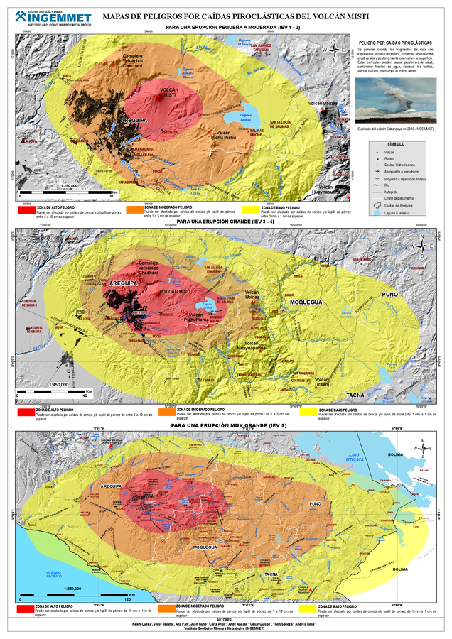
Mapa de Peligros por Caídas Piroclásticas del Volcán Misti
(Map of Hazards from Pyroclastic Falls of El Misti Volcano)
Cueva, K., Mariño, J., Pari, A., Cuno, J., Arias, C., Ancalle, A., Quispe, C., Soncco, Y., Ticse, A. (2025). Mapa de Peligros por Caídas Piroclásticas del Volcán Misti. Instituto Geológico Minero y Metalúrgico (INGEMMET). https://hdl.handle.net/20.500.12544/5309
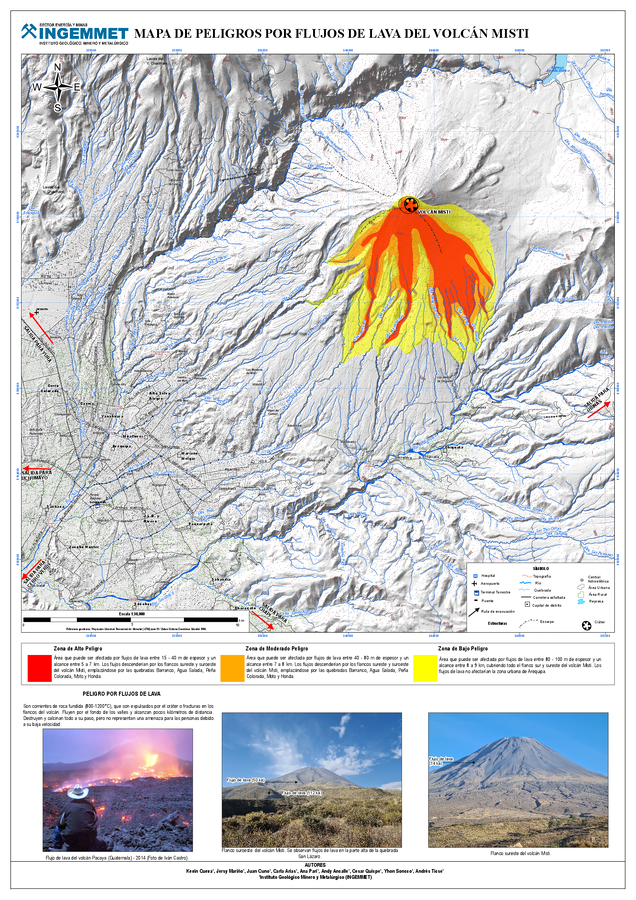
Official, Map sheet or poster
Mapa de Peligros por Flujos de Lava del Volcán Misti
(Map of Hazards from Lava Flows of El Misti Volcano)
Cueva, K., Mariño, J., Cuno, J., Arias, C., Pari, A., Ancalle, A., Quispe, C., Soncco, Y., Ticse, A. (2025). Mapa de Peligros por Flujos de Lava del Volcán Misti. Instituto Geológico Minero y Metalúrgico (INGEMMET). https://hdl.handle.net/20.500.12544/5309
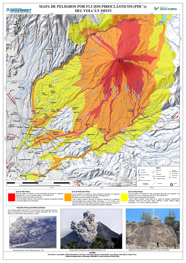
Official, Map sheet or poster
Mapa de Peligros por Flujos Piroclásticos (PDC's) del Volcán Misti
(Hazard Map for Pyroclastic Flows (PDCs) of El Misti Volcano)
Cueva, K., Mariño, J., Charbonnier, S., Arias, C., Cuno, J., Pari, A., Ancalle, A., Quispe, C., Soncco, Y., Ticse, A. (2025). Mapa de Peligros por Flujos Piroclásticos (PDC's) del Volcán Misti. Instituto Geológico Minero y Metalúrgico (INGEMMET). https://hdl.handle.net/20.500.12544/5309
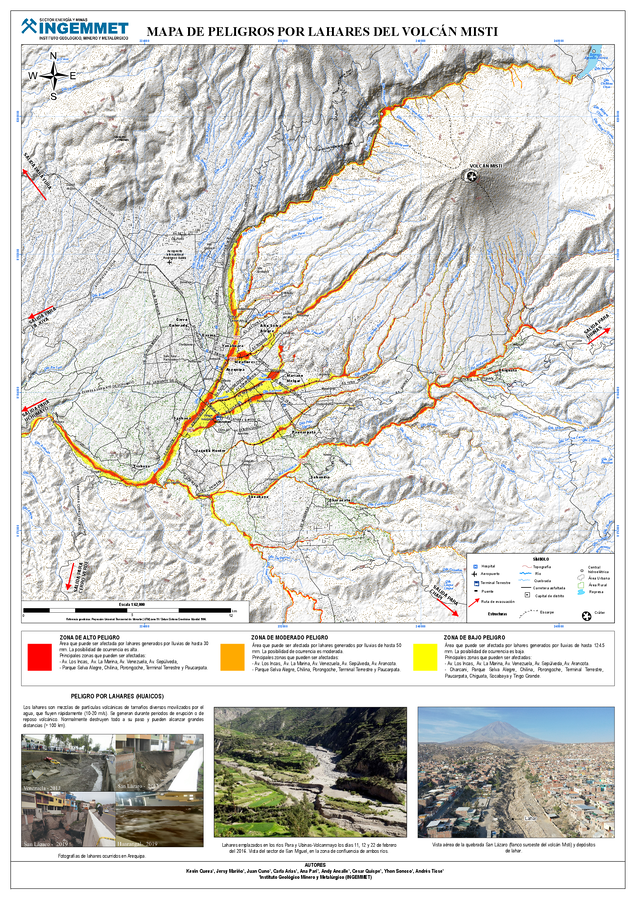
Official, Map sheet or poster
Mapa de Peligros por Lahares del Volcán Misti
(Lahar Hazard Map of El Misti Volcano)
Cueva, K., Mariño, J., Cuno, J., Arias, C., Pari, A., Ancalle, A., Quispe, C., Soncco, Y., Ticse, A. (2025). Mapa de Peligros por Lahares del Volcán Misti. Instituto Geológico Minero y Metalúrgico (INGEMMET). https://hdl.handle.net/20.500.12544/5309
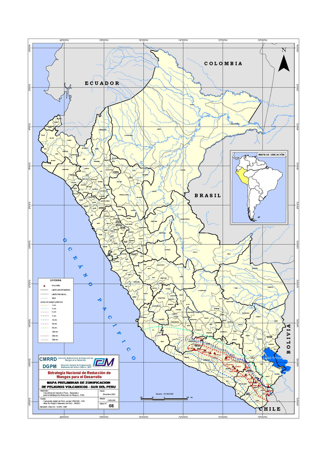
Official, Map sheet or poster
Mapa Preliminar de Zonificación de Peligros Volcanicos - Sur del Perú
(Preliminary Map of Volcanic Hazards Zoning - Southern Peru)
Comisión Multisectorial de Reducción de Riesgos en el Desarrollo (CMRRD) & Dirección General de Programación Multianual del Sector Público - MEF (DGPM) (2003). Mapa preliminar de zonificación de peligros volcánicos - Sur del Perú. Estrategía Nacional de Reducción de Riesgos para el Desarrollo. Escala 1:3000000
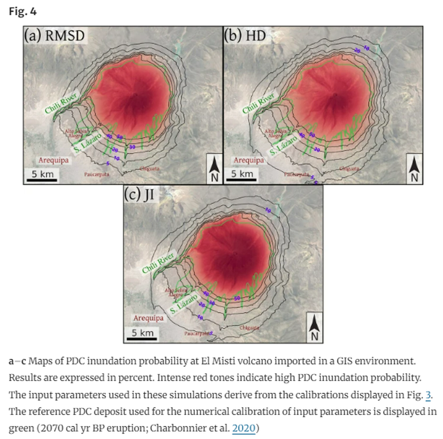
Figure in a journal article
Maps of PDC inundation probability at El Misti volcano imported in a GIS environment
Figure 4 in: Aravena, A., Bevilacqua, A., de’Michieli Vitturi, M., Esposti Ongaro, T., Neri, A., & Cioni, R. (2022). Calibration strategies of PDC kinetic energy models and their application to the construction of hazard maps. Bulletin of Volcanology, 84(3), 29.
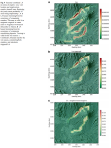
Figure in a journal article
Seasonal combined LA (in terms of eruptive size, vent location and eruptive/noneruptive hazard) map, displaying the yearly mean probability of areas being impacted by LA
Figure 9 in: Sandri, L., Thouret, J. C., Constantinescu, R., Biass, S., & Tonini, R. (2014). Long-term multi-hazard assessment for El Misti volcano (Peru). Bulletin of volcanology, 76(2), 771. https://doi.org/10.1007/s00445-013-0771-9