
Advanced Search for Maps
Showing 21-30 of 2217
Official, Map sheet or poster
Adatarayama Volcano Disaster Prevention Map [Nihonmatsu City]
Nihonmatsu City. (2016). Adatarayama Volcano Disaster Prevention Map [Nihonmatsu City].
Official, Map sheet or poster
Adatarayama Volcano Disaster Prevention Map [Otama Village]
Fukushima City. (2016). Adatarayama Volcano Disaster Prevention Map [Fukushima City].
Official, Map sheet or poster
Adatarayama Volcano Disaster Prevention Map [Otama Village]
Otama Village. (2016). Adatarayama Volcano Disaster Prevention Map [Otama Village].
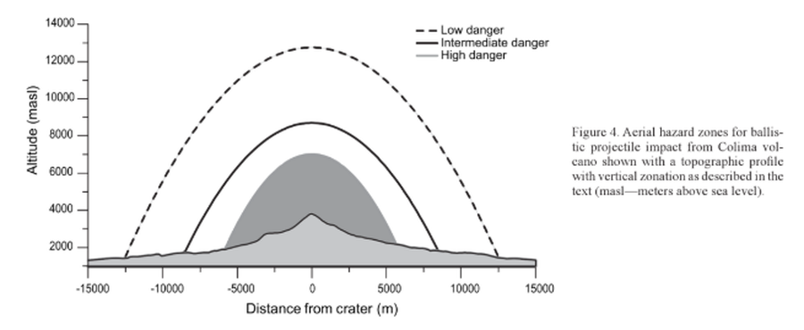
Figure in a journal article
Aerial hazard zones for ballistic impact from Colima volcano shown with a topographic profile with vertical zonation as described in the text
Figure 4 in: Alatorre-Ibargüengoitia, M.A., Delgado-Granados, H., & Farraz-Montes, I.A. (2006). Hazard zoning for ballistic impact during volcanic explosions at Volcán de Fuego de Colima (México). In: Siebe, C., Macías Gerardo, J.L., Aguirre-Díaz, J. (Eds.). Neogene-Quaternary Continental Margin Volcanism: A perspective from México. Geological Society of America, Special Papers 402, p. 209-216. https://doi.org/10.1130/2006.2402(09)
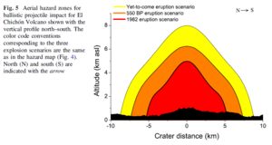
Figure in a journal article
Aerial hazard zones for ballistic projectile impact for El Chichón Volcano shown with the vertical profile north–south
Figure 5 in: Alatorre-Ibargüengoitia, M.A., Morales-Iglesias, H., Ramos-Hernández, S.G., Jon-Selvas, J., & Jiménez-Aguilar, J.M. (2016). Hazard zoning for volcanic ballistic impacts at El Chichón Volcano (Mexico). Natural Hazards, 81(3), p. 1733-1744. https://doi.org/10.1007/s11069-016-2152-0
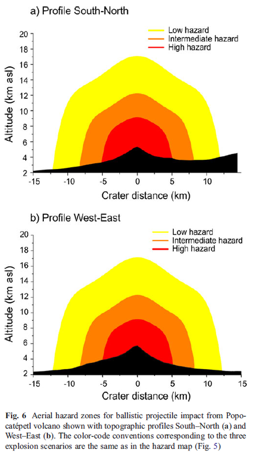
Figure in a journal article
Aerial hazard zones for ballistic projectile impact from Popocatépetl volcano shown with topographic profiles
Figure 6 in: Alatorre-Ibargüengoitia, M. A., Delgado-Granados, H., & Dingwell, D. B. (2012). Hazard map for volcanic ballistic impacts at Popocatépetl volcano (Mexico). Bulletin of Volcanology, 74(9), p. 2155-2169. https://doi.org/10.1007/s00445-012-0657-2
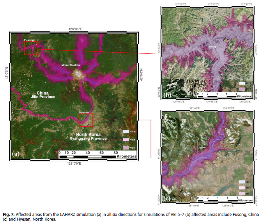
Figure in a journal article
Affected areas from the LAHARZ simulation
Figure 7 in: Achmad, A.R., Lee, S., Park, S. Eom, J., & Lee, C.-W. (2020). Estimating the potential risk of the Mt. Baekdu Volcano using a synthetic interferogram and the LAHARZ inundation zone. Geosciences Journal. 24, 755–768. https://doi.org/10.1007/s12303-020-0032-9
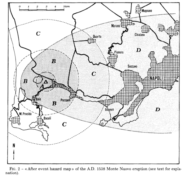
Figure in a journal article
After event hazard map of the A.D. 1538 Monte Nuevo eruption
Figure 2 in: Rosi, M., & Santacroce, R. (1984). Volcanic hazard assessment in the Phlegraean Fields: a contribution based on stratigraphic and historical data. Bulletin Volcanologique, 47(2), p. 359-370. https://doi.org/10.1007/BF01961567
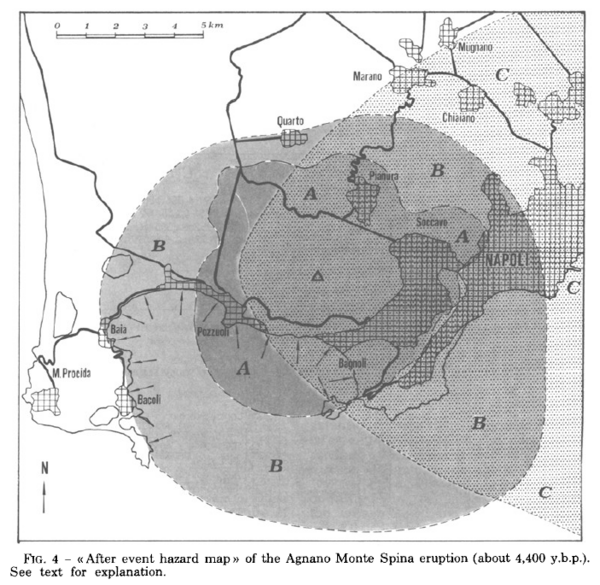
Figure in a journal article
After event hazard map of the Agnano Monte Spina eruption (about 4,400 y.b.p.)
Figure 4 in: Rosi, M. & Santacroce, R. (1984). Volcanic hazard assessment in the Phlegraean Fields: a contribution based on stratigraphic and historical data. Bulletin Volcanologique, 47(2), p. 359-370. https://doi.org/10.1007/BF01961567
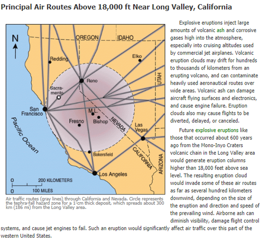
Official, Figure on website
Air traffic routes (gray lines) through California and Nevada. Circle represents the tephra-fall hazard zone for a 1-cm thick deposit, which spreads about 300 km (186 mi) from the Long Valley area.
U.S. Geological Survey (USGS). (2012). Air traffic routes (gray lines) through CA and Nevada. U.S. Geological Survey. Long Valley Caldera Hazards, Principal Air Routes Above 18,000 ft Near Long Valley, California. https://www.usgs.gov/volcanoes/long-valley-caldera/principal-air-routes-above-18000-ft-near-long-valley-california