
Advanced Search for Maps
Showing 61-70 of 1194
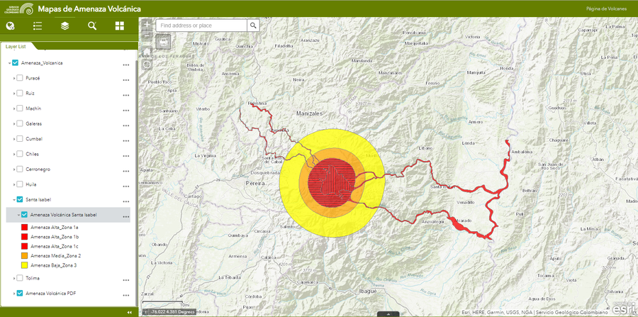
Official, Interactive web-based map
Amenaza Santa Isabel
(Santa Isabel Hazards)
Servicio Geológico Colombiano (SGC). Amenaza Santa Isabel.
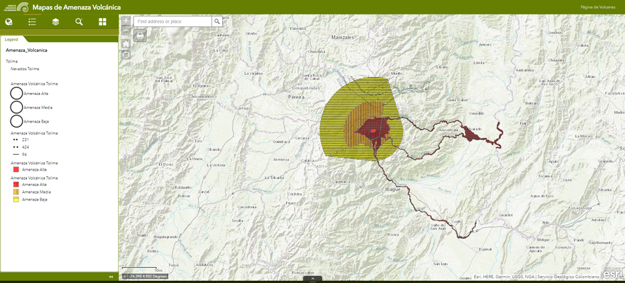
Official, Interactive web-based map
Amenaza Tolima
(Tolima Hazards)
Servicio Geológico Colombiano (SGC). Amenaza Tolima.
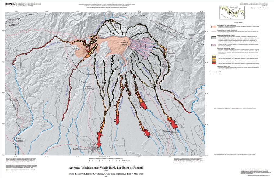
Official (foreign agency), Insert/poster-size map with accompanying report
Amenaza Volcánica en el Volcán Barú, República de Panamá
(Volcano Hazards of Volcán Barú, Republic of Panamá)
Plate 1 (Spanish) in: Sherrod, D. R., Vallance, J. W., Espinosa, A. T., & McGeehin, J. P. (2007). Volcan Baru—eruptive history and volcano-hazards assessment. U.S. Geological Survey, Open-File Report, 2007-1401.
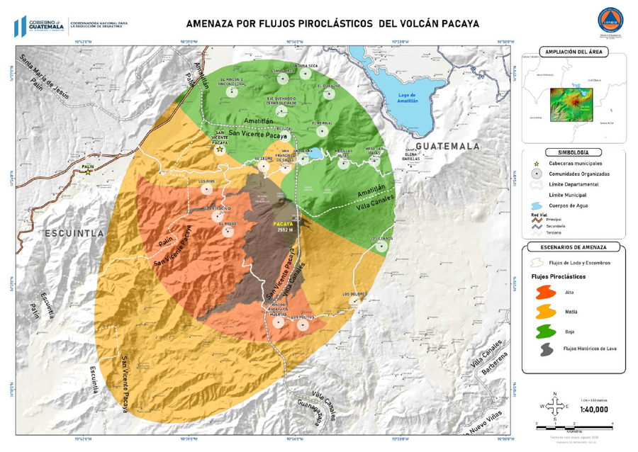
Official, Figure in hazard assessment
Amenazas por Flujos Piroclásticos del Volcán Pacaya
(Hazards from Pyroclastic Flows from Pacaya Volcano)
3.2.1 in: Coordinadora Nacional para la Reducción de Desastres (CONRED). (2021). Protocolo Operativo por Actividad Efusiva del Volcán Pacaya. https://conred.gob.gt/documentos/planes/DRE_20210211_01_PROTOCOLO_OPERATIVO_POR_ACTIVIDAD_EFUSIVA_VOLCAN_PACAYA.pdf
Official, Figure in a journal article
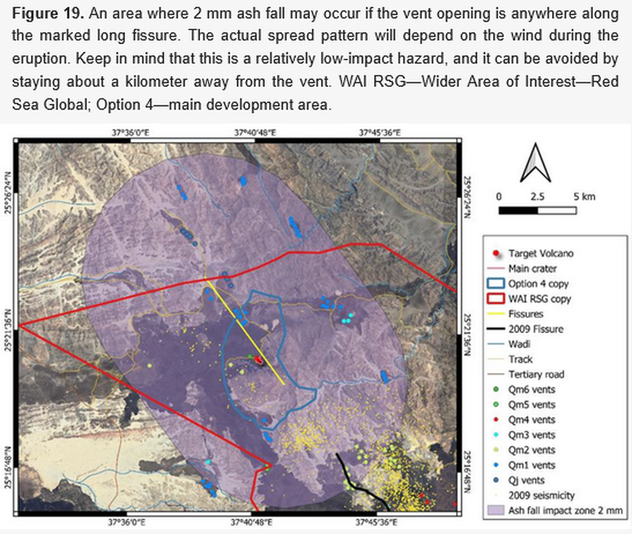
An area where 2 mm ash fall may occur if the vent opening is anywhere along the marked long fissure
Figure 19 in: Németh, K., Sowaigh, A., Ashor, M., Toni, M., & Sokolov, V. (2026). Volcanic Hazard Assessment of a Monogenetic Volcanic Field with Sporadic and Limited Information: Deterministic Approach for Harrat Lunayyir, Saudi Arabia. GeoHazards, 7(1), 33. https://doi.org/10.3390/geohazards7010033
Official, Figure in a journal article
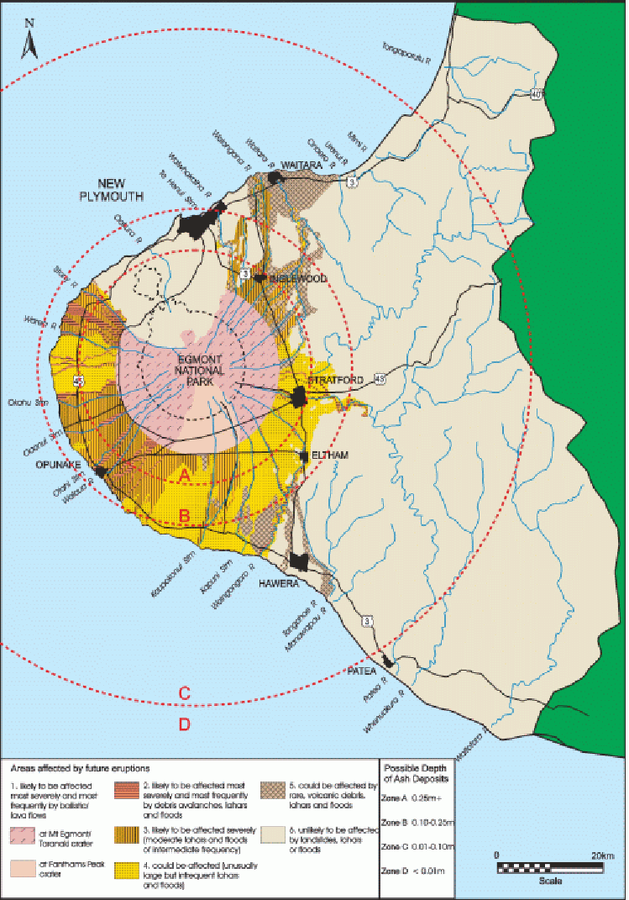
An example of a volcanic hazard map for Mount Taranaki
Figure 2 in: Becker, J.S., Saunders, W.S.A., Robertson, C.M., Leonard, G.S., & Johnston, D.M. (2010). A synthesis of challenges and opportunities for reducing volcanic risk through land use planning in New Zealand. The Australasian Journal of Disaster and Trauma Studies, 2010-1. (Simplified from: Taranaki Regional Council 2004)
Official, Figure in a journal article
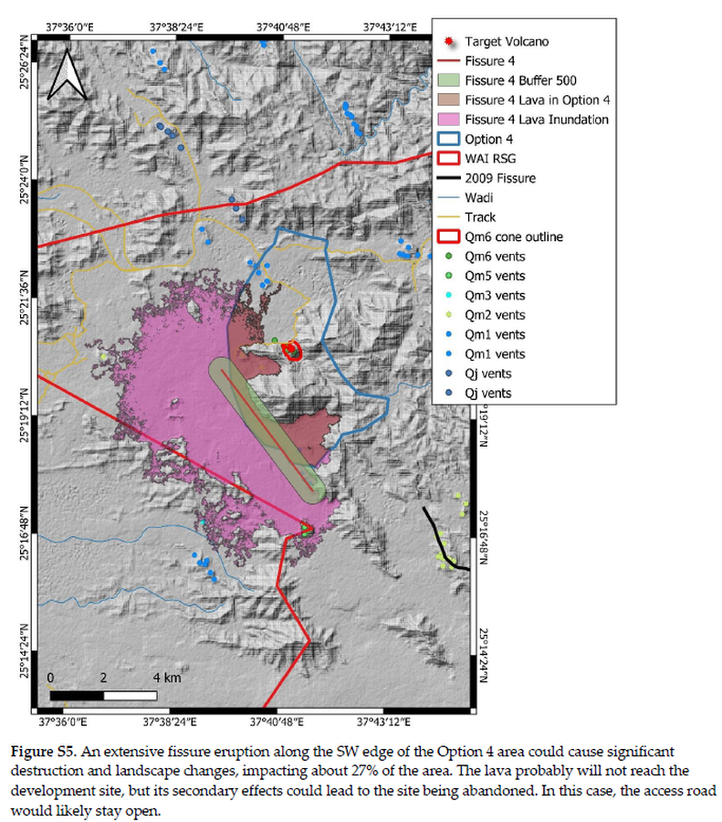
An extensive fissure eruption along the SW edge of the Option 4 area could cause significant destruction and landscape changes
Figure S5 in: Németh, K., Sowaigh, A., Ashor, M., Toni, M., & Sokolov, V. (2026). Volcanic Hazard Assessment of a Monogenetic Volcanic Field with Sporadic and Limited Information: Deterministic Approach for Harrat Lunayyir, Saudi Arabia. GeoHazards, 7(1), 33. https://doi.org/10.3390/geohazards7010033
Official, Figure in hazard assessment
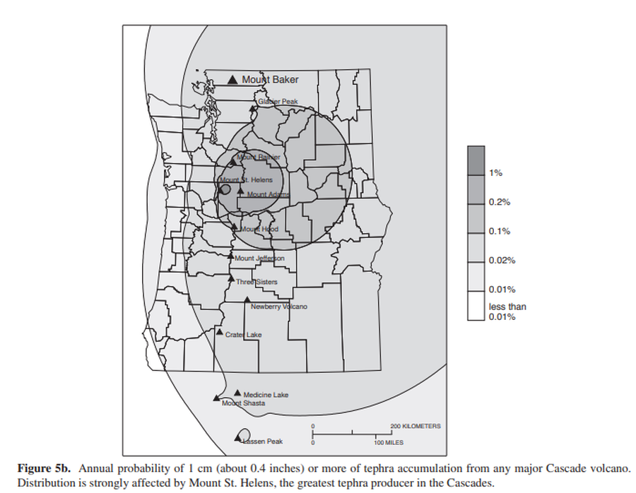
Annual probability of 1 cm (about 0.4 inches) or more of tephra accumulation from any major Cascade volcano
Figure 5b in: Gardner, C.A., Scott, K.M., Miller, C.D., Myers, B., Hildreth, W., & Pringle, P.T. (1995). Potential volcanic hazards from future activity of Mount Baker, Washington. U.S. Geological Survey, Open-File Report 95-498, 16 p., 1 plate, scale 1:100,000. https://doi.org/10.3133/ofr95498
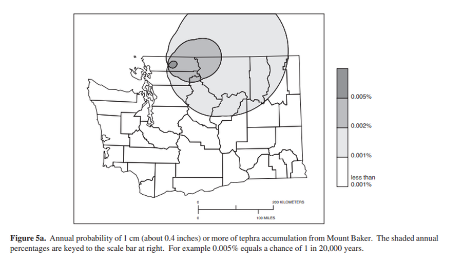
Official, Figure in hazard assessment
Annual probability of 1 cm (about 0.4 inches) or more of tephra from Mount Baker.
Figure 5a in: Gardner, C.A., Scott, K.M., Miller, C.D., Myers, B., Hildreth, W., & Pringle, P.T. (1995). Potential volcanic hazards from future activity of Mount Baker, Washington. U.S. Geological Survey, Open-File Report 95-498, 16 p., 1 plate, scale 1:100,000. https://doi.org/10.3133/ofr95498
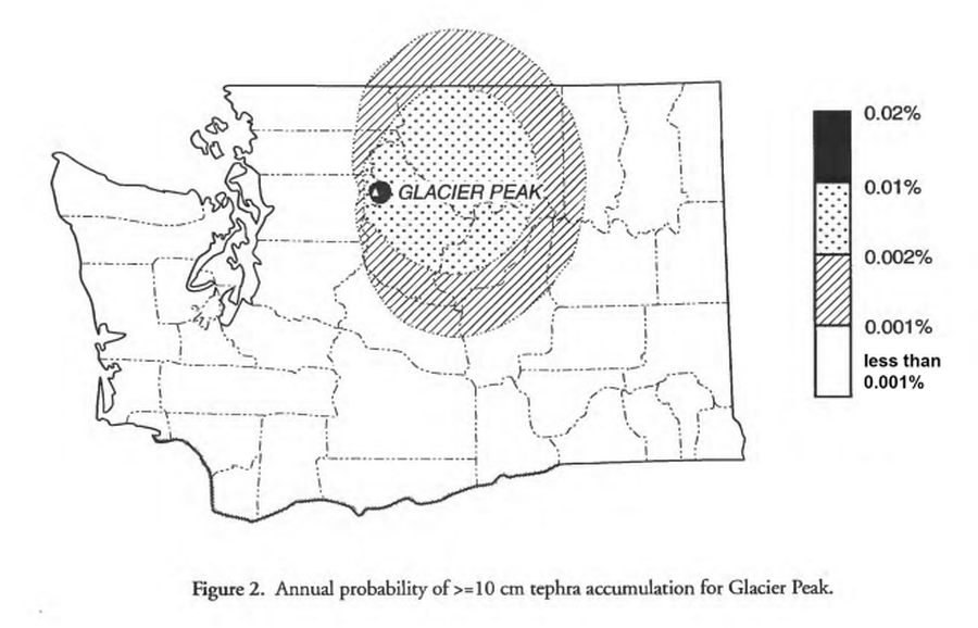
Official, Figure in hazard assessment
Annual probability of >=10 cm tephra accumulation for Glacier Peak
Figure 2 in: Waitt, R.B., Mastin, L.G., & Begét, J.E. (1995). Volcanic-Hazard Zonation for Glacier Peak Volcano, Washington. U.S. Geological Survey, Open-File Report 95-499, 9 p., 1 plate. https://doi.org/10.3133/ofr95499