
Advanced Search for Maps
Showing 31-40 of 272

Figure in a thesis or dissertation
Batur Community Hazard Map
Figure 5.5 in: Donovan, K.H.M. (2010). Cultural responses to volcanic hazards on Mt Merapi, Indonesia. University of Plymouth, PhD Dissertation.
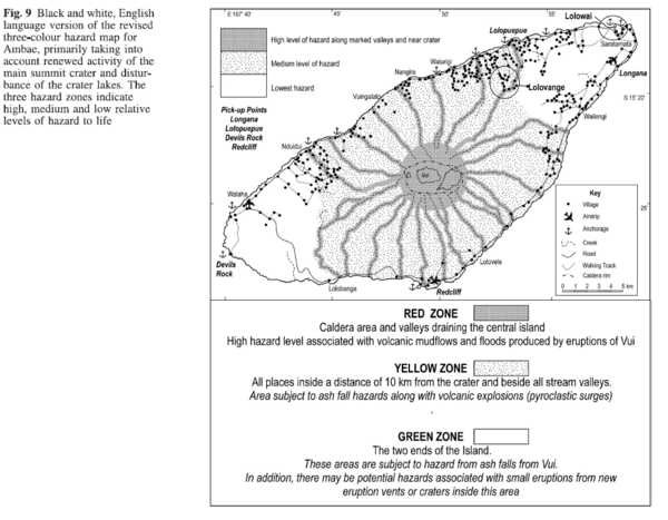
Figure in a journal article
Black and white, English language version of the revised three-colour hazard map for Ambae, primarily taking into account renewed activity of the main summit crater and disturbance of the crater lakes
Figure 9 in: Cronin, S.J., Gaylord, D.R., Charley, D., Alloway, B.V., Wallez, S., & Esau, J.W. (2004). Participatory methods of incorporating scientific with traditional knowledge for volcanic hazard management on Ambae Island, Vanuatu. Bulletin of volcanology, 66(7), p. 652-668. https://doi.org/10.1007/s00445-004-0347-9
Official, Map sheet or poster
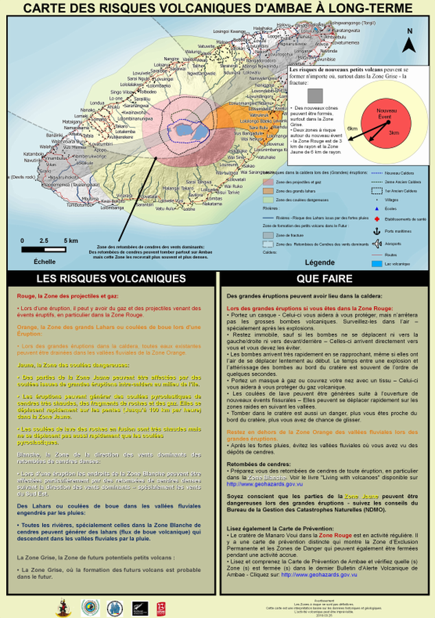
Carte des Risques Volcaniques d'Ambae à Long-terme
(Ambae Long-Term Background Volcanic Hazards Map)
Vanuatu Meteorology & Geo-Hazards Department. (2019). Carte des Risques Volcaniques d'Ambae à Long-terme. Government of Vanuatu, Vanuatu Meteorology & Geo-Hazards Department, Vanuatu National Disaster Risk Management Office, New Zealand Foreign Affairs & Trade Aid Programme, GNS Science.
Official, Map sheet or poster
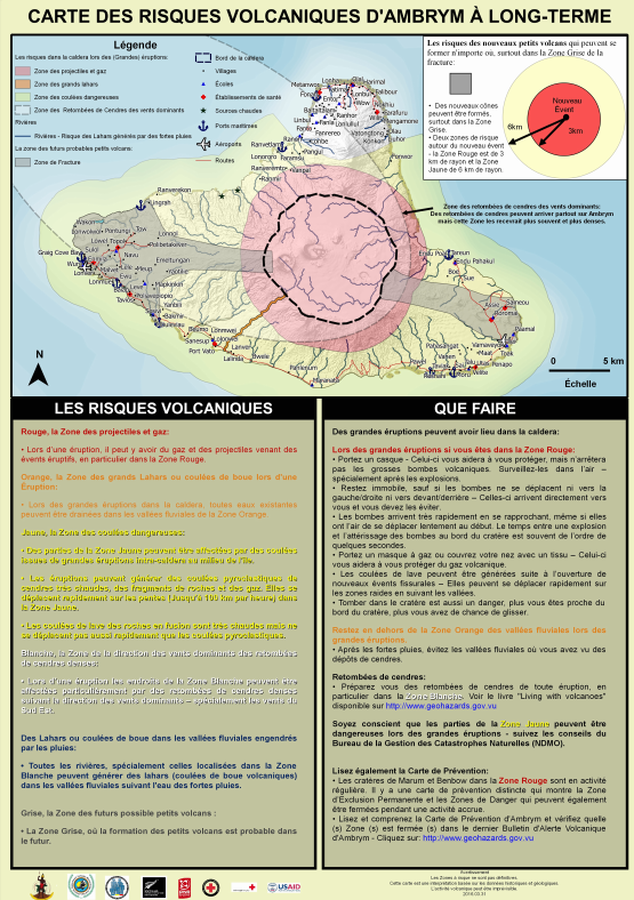
Carte des Risques Volcaniques d'Ambrym à Long-terme
(Ambrym Long-Term Background Volcanic Hazards Map)
Vanuatu Meteorology & Geo-Hazards Department. (2016). Carte des Risques Volcaniques d'Ambrym à Long-terme. Government of Vanuatu, Vanuatu Meteorology & Geo-Hazards Department, Vanuatu National Disaster Risk Management Office, New Zealand Foreign Affairs & Trade Aid Programme, GNS Science, The Vanuatu Red Cross Society, Croix Rouge Francaise, USAID.
Official, Map sheet or poster
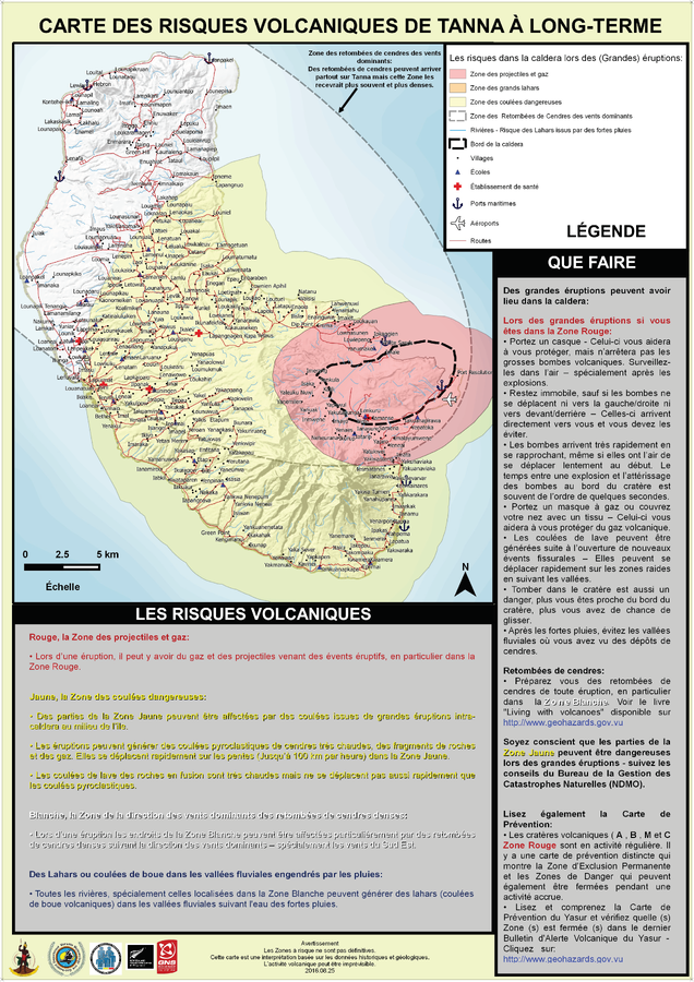
Carte des Risques Volcaniques de Tanna à Long-Terme
(Tanna Long-Term Background Volcanic Hazards Map)
Vanuatu Meteorology & Geo-Hazards Department. (2016). Carte des Risques Volcaniques de Tanna à Long-Terme. Government of Vanuatu, Vanuatu Meteorology & Geo-Hazards Department, Vanuatu National Disaster Risk Management Office, New Zealand Foreign Affairs & Trade Aid Programme, GNS Science.
Soufrière St. Vincent, Saint Vincent and the Grenadines
Official, Figure on website
Chateaubelair & Fitz Hughes Community Multi-Hazard Map
The University of the West Indies Seismic Research Centre (UWI-SRC) and National Emergency Management Organization (NEMO). (2021). Chateaubelair & Fitz Hughes Community Multi-Hazard Map. https://uwiseismic.com/wp-content/uploads/2021/10/Chateau-fitzhughes_Hazard-Map-scaled.jpg
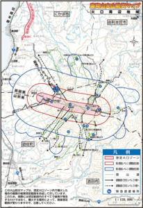
Official, Map in a booklet, long fact-sheet, or handbook
Chokaisan Hazard Map - Area around Chokaisan
Page 15 in: Volcano Disaster Management Councils of Chokaisan. (2019). Chokaisan Volcanic Disaster Prevention Map.
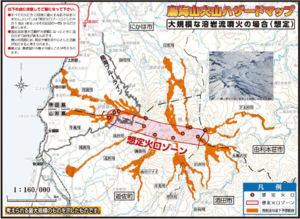
Official, Map in a booklet, long fact-sheet, or handbook
Chokaisan Hazard Map - In case of large scale lava flow eruption
Page 12 in: Volcano Disaster Management Councils of Chokaisan. (2019). Chokaisan Volcanic Disaster Prevention Map.
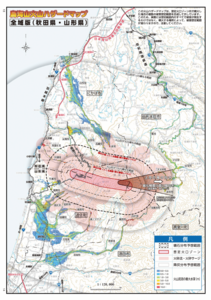
Official, Map in a booklet, long fact-sheet, or handbook
Chokaisan Hazard Map - Whole Area Version (Akita/Yamagata)
Page 13-14 in: Volcano Disaster Management Councils of Chokaisan. (2019). Chokaisan Volcanic Disaster Prevention Map.
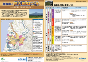
Official, Flyer, brochure, short fact-sheet, or handout
Chokaisan Volcanic Alert Levels
Japan Meteorological Agency. (2018). Chokaisan Volcanic Alert Levels. Volcano Monitoring and Warning Center, Volcano Division, Earthquake and Volcano Department.