
Advanced Search for Maps
Showing 51-60 of 272
Official, Flyer, brochure, short fact-sheet, or handout
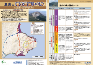
Esan Volcanic Alert Levels
Japan Meteorological Agency. (2018). Esan Volcanic Alert Levels. Volcano Monitoring and Warning Center, Volcano Division, Earthquake and Volcano Department.
Official, Map in a booklet, long fact-sheet, or handbook
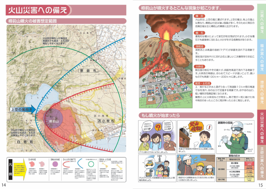
Estimated damage range of a Tarumaeyama eruption
Page 14 in: Eniwa City Hall General Affairs Department. (2021). Eniwa City Disaster Prevention Guidebook. 19 p.

Figure in a journal article
Estimated Travel Time of Mudflows at Mount Hood, Oregon
Preppernau, C. A., & Jenny, B. (2016). Estimated travel time of mudflows at Mount Hood, Oregon. Journal of Maps, 12(5), p. 711-715. https://doi.org/10.1080/17445647.2015.1120244
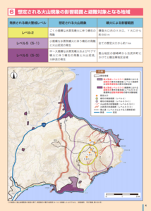
Official, Map in a booklet, long fact-sheet, or handbook
Expected scope of volcanic phenomena and areas targeted for evacuation
Page 4 in: Hakodate City. (2016). Disaster Prevention Handbook of Esan. 12 p.
Soufrière St. Vincent, Saint Vincent and the Grenadines
Official, Figure on website
Fancy Community Multi-Hazard Map
The University of the West Indies Seismic Research Centre (UWI-SRC) and National Emergency Management Organization (NEMO). (2021). Fancy Community Multi-Hazard Map. https://uwiseismic.com/wp-content/uploads/2021/10/Fancy-Hazard-Map-scaled.jpg
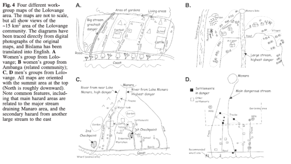
Figure in a journal article
Four different workgroup maps of the Lolovange area
Figure 4 in: Cronin, S.J., Gaylord, D.R., Charley, D., Alloway, B.V., Wallez, S., & Esau, J.W. (2004). Participatory methods of incorporating scientific with traditional knowledge for volcanic hazard management on Ambae Island, Vanuatu. Bulletin of volcanology, 66(7), p. 652-668. https://doi.org/10.1007/s00445-004-0347-9

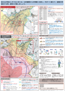
Official, Map sheet or poster
Fuji City Volcano Disaster Prevention Map
Figure 6.3.13 in: Mt. Fuji Hazard Map Review Committee. (2004). Mt. Fuji Hazard Map Review Committee Report. June 2004. https://www.bousai.go.jp/kazan/fuji_map/pdf/report_200406.pdf
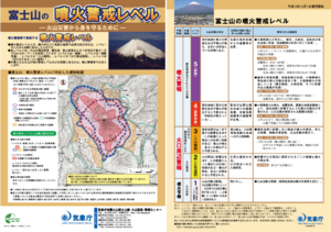
Official, Flyer, brochure, short fact-sheet, or handout
Fujisan Volcanic Alert Levels
Japan Meteorological Agency. (2016). Fujisan Volcanic Alert Levels. Volcano Monitoring and Warning Center, Volcano Division, Earthquake and Volcano Department.
Official, Map sheet or poster
Fujiyoshida City Volcano Disaster Prevention Map
Figure 6.3.11 in: Mt. Fuji Hazard Map Review Committee. (2004). Mt. Fuji Hazard Map Review Committee Report. June 2004. https://www.bousai.go.jp/kazan/fuji_map/pdf/report_200406.pdf
Soufrière St. Vincent, Saint Vincent and the Grenadines
Official, Figure on website
Georgetown Community Multi-Hazard Map
The University of the West Indies Seismic Research Centre (UWI-SRC) and National Emergency Management Organization (NEMO). (2021). Georgetown Community Multi-Hazard Map. https://uwiseismic.com/wp-content/uploads/2021/10/Georgetown-Hazard-Map-scaled.jpg