
Advanced Search for Maps
Showing 41-50 of 272
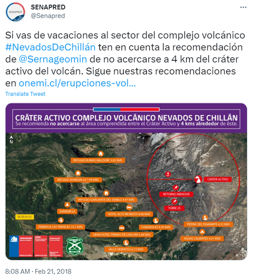
Official, Map in an information statement
Cráter Activo Complejo Volcánico Nevados de Chillán
(Nevados de Chillán Active Crater Complex )
Servicio Nacional de Geología y Minería (SERNAGEOMIN) & Oficina Nacional de Emergencia del Ministerio del Interior y Seguridad Pública (ONEMI). (2018). Cráter Activo Complejo Volcánico Nevados de Chillán. Twitter. https://twitter.com/Senapred/status/966343871520215040
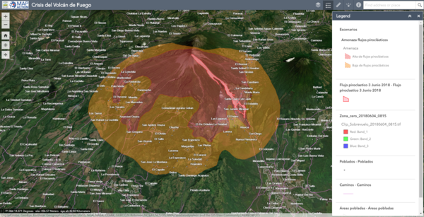
Official, Interactive web-based map
Crisis del Volcán de Fuego
(Fuego Volcano Crisis)
Instituto Nacional de Sismología, Vulcanologia, Meteorologia e Hidrología (INSIVUMEH), Map Action, Volcano Disaster Assistance Program (VDAP), U.S. Geological Survey (USGS), University of Edinburgh & Michigan Technological University. (2018). Crisis del Volcan Fuego.
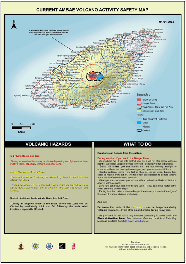
Official, Map in an information statement
Current Ambae Volcano Activity Safety Map
Vanuatu Meteorology & Geo-Hazards Department. (2018). Current Ambae Volcano Activity Safety Map 04.04.2018. Government of Vanuatu, Vanuatu Meteorology & Geo-Hazards Department, Vanuatu National Disaster Risk Management Office, New Zealand Foreign Affairs & Trade Aid Programme, GNS Science.
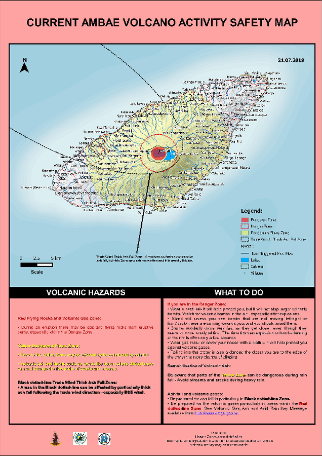
Official, Map in an information statement
Current Ambae Volcano Activity Safety Map
Vanuatu Meteorology & Geo-Hazards Department. (2018). Current Ambae Volcano Activity Safety Map 21.07.2018. Government of Vanuatu, Vanuatu Meteorology & Geo-Hazards Department, Vanuatu National Disaster Risk Management Office, New Zealand Foreign Affairs & Trade Aid Programme, GNS Science.
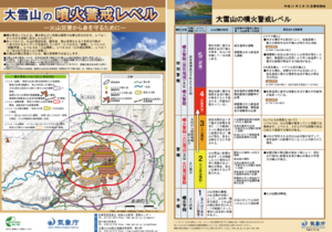
Official, Flyer, brochure, short fact-sheet, or handout
Daisetsusan Volcanic Alert Levels
Japan Meteorological Agency. (2019). Daisetsusan Volcanic Alert Levels. Volcano Monitoring and Warning Center, Volcano Division, Earthquake and Volcano Department.
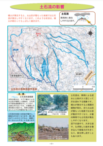
Official, Map in a booklet, long fact-sheet, or handbook
Debris flow dangerous area prediction map
Page 8 in: Nasudake Volcano Disaster Prevention Council. (2014). Nasudake Volcano Disaster Prevention Handbook.
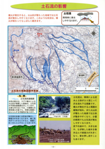
Official, Map in a booklet, long fact-sheet, or handbook
Debris flow dangerous area prediction map
Page 8 in: Nasudake Volcano Disaster Prevention Council. (2010). Volcanic disaster prevention handbook of Mt. Nasudake.
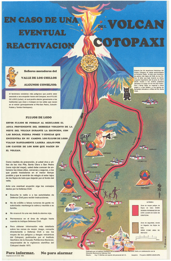
Official, Sign or billboard
En Caso de Una Eventual Reactivacion del Volcan Cotopaxi
(In Case of a Possible Reactivation of the Cotopaxi Volcano)
Mothes, P. (1990). En Caso de Una Eventual Reactivacion del Volcan Cotopaxi. Instituto Geofísico de la Escuela Politecnica Nacional and Dirección Nacional (IG-EPN) de Defensa Civil, Quito.
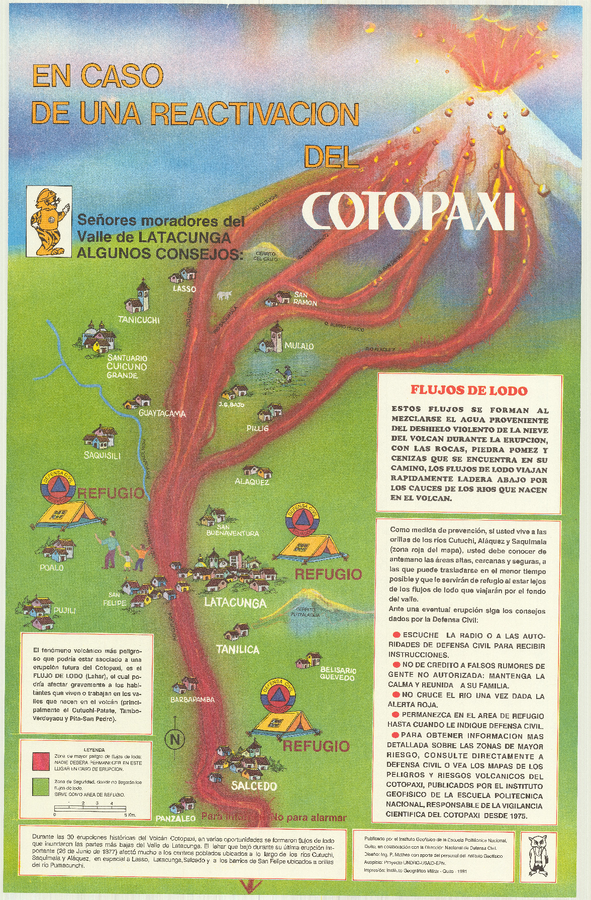
Official, Sign or billboard
En Caso de Una Eventual Reactivacion del Volcan Cotopaxi
(In Case of a Possible Reactivation of the Cotopaxi Volcano)
Mothes, P. (1991). En Caso de Una Eventual Reactivacion del Volcan Cotopaxi. Instituto Geofísico de la Escuela Politecnica Nacional (IG-EPN) and Dirección Nacional de Defensa Civil, Quito.
Official, Map in a booklet, long fact-sheet, or handbook
Enlarged view around Yakeyama
Akita Prefecture. (2002). Akita-Yakeyama Volcanic Disaster Prevention Map.