
Advanced Search for Maps
Showing 61-70 of 906
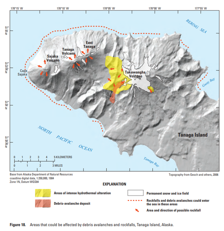
Official, Figure in hazard assessment
Areas that could be affected by debris avalanches and rockfalls, Tanaga Island, Alaska
Figure 18 in: Coombs, M.L., McGimsey, R.G. & Browne, B.L. (2007). Preliminary volcano-hazard assessment for the Tanaga volcanic cluster, Tanaga Island, Alaska. U.S. Geological Survey, Scientific Investigations Report 2007-5094, 41 p., 1 plate. https://doi.org/10.3133/sir20075094
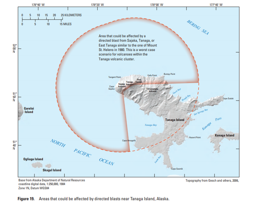
Official, Figure in hazard assessment
Areas that could be affected by directed blasts near Tanaga Island, Alaska
Figure 19 in: Coombs, M.L., McGimsey, R.G. & Browne, B.L. (2007). Preliminary volcano-hazard assessment for the Tanaga volcanic cluster, Tanaga Island, Alaska. U.S. Geological Survey, Scientific Investigations Report 2007-5094, 41 p., 1 plate. https://doi.org/10.3133/sir20075094
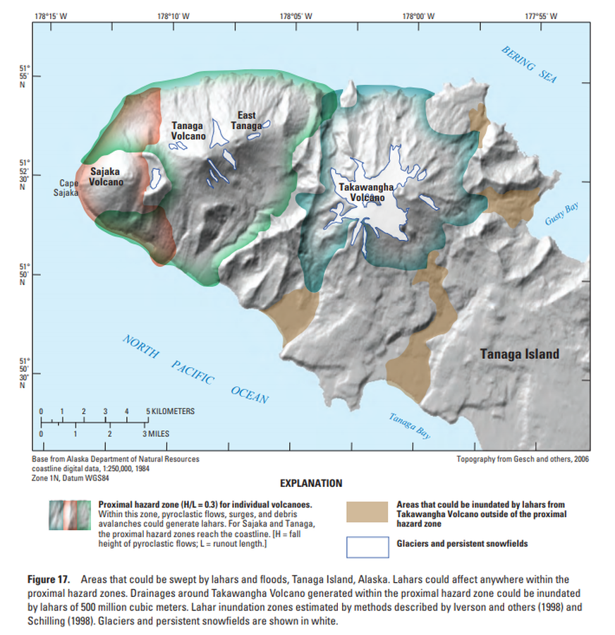
Official, Figure in hazard assessment
Areas that could be swept by lahars and floods, Tanaga Island, Alaska
Figure 17 in: Coombs, M.L., McGimsey, R.G. & Browne, B.L. (2007). Preliminary volcano-hazard assessment for the Tanaga volcanic cluster, Tanaga Island, Alaska. U.S. Geological Survey, Scientific Investigations Report 2007-5094, 41 p., 1 plate. https://doi.org/10.3133/sir20075094
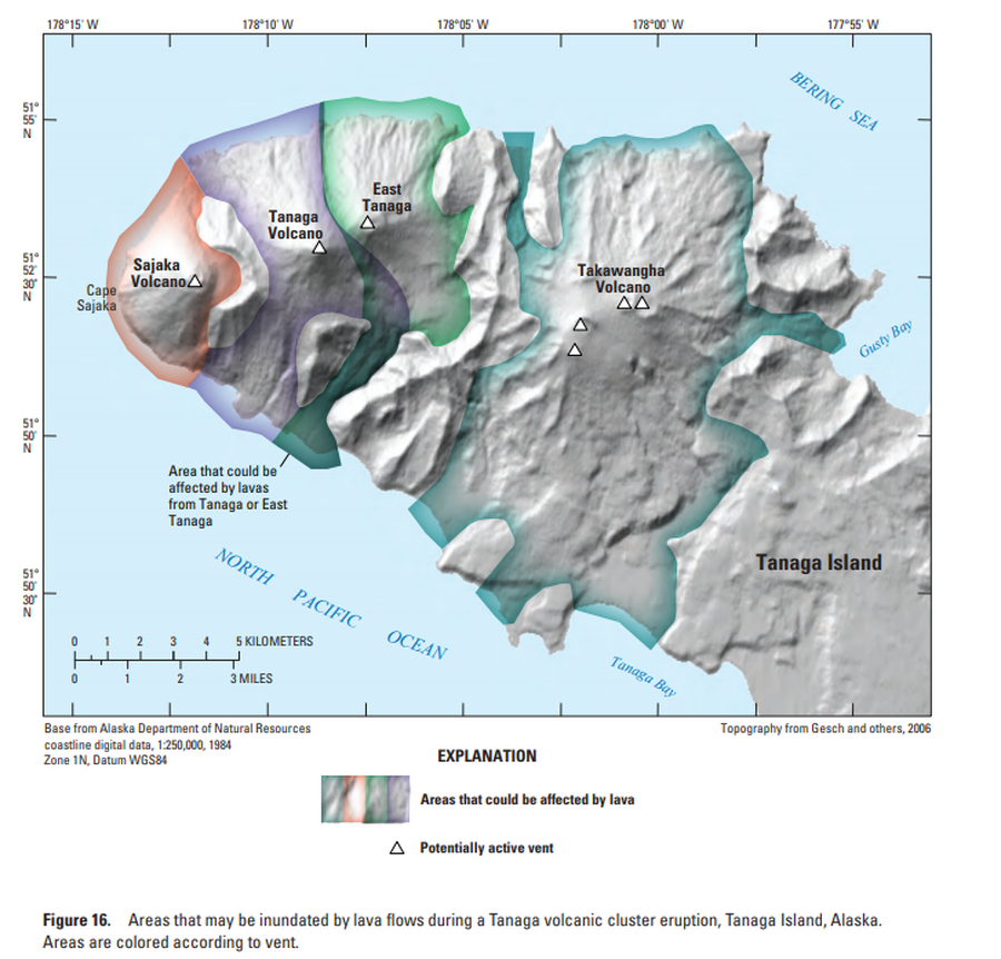
Official, Figure in hazard assessment
Areas that may be inundated by lava flows during a Tanaga volcanic cluster eruption, Tanaga Island, Alaska
Figure 16 in: Coombs, M.L., McGimsey, R.G. & Browne, B.L. (2007). Preliminary volcano-hazard assessment for the Tanaga volcanic cluster, Tanaga Island, Alaska. U.S. Geological Survey, Scientific Investigations Report 2007-5094, 41 p., 1 plate. https://doi.org/10.3133/sir20075094
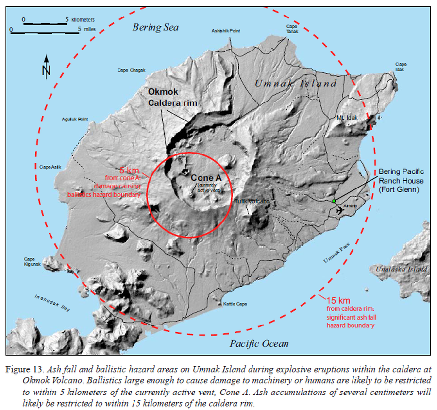
Official, Figure in hazard assessment
Ash fall and ballistic hazard areas on Umnak Island during explosive eruptions within the caldera at Okmok Volcano
Figure 13 in: Beget, J.E., Larsen, J.F., Neal, C.A., Nye, C.J., & Schaefer, J.R. (2005). Preliminary volcano-hazard assessment for Okmok Volcano, Umnak Island, Alaska. Department of Natural Resources, Division of Geological & Geophysical Surveys (DGGS), Report of Investigation RI 2004-3, 32 p., 1 sheet, scale 1:150,000. http://doi.org/10.14509/7042
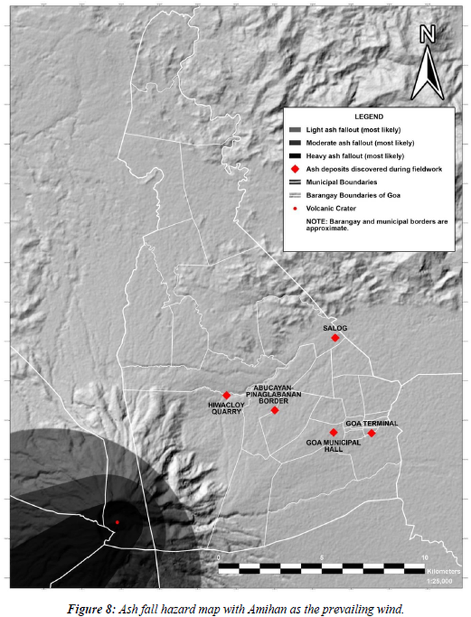
Figure in a thesis or dissertation
Ash fall hazard map with Amihan as the prevailing wind
Figure 8 in: Daita, T.J.E. (2020). Preliminary Volcanic Hazard Assessment of Goa, Camarines Sur, Philippines. Thesis, Partido State University, Goa, Camarines Sur, Philippines.
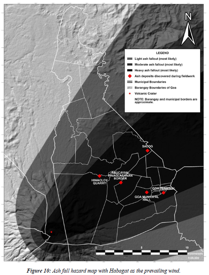
Figure in a thesis or dissertation
Ash fall hazard map with Habagat as the prevailing wind
Figure 10 in: Daita, T.J.E. (2020). Preliminary Volcanic Hazard Assessment of Goa, Camarines Sur, Philippines. Thesis, Partido State University, Goa, Camarines Sur, Philippines.
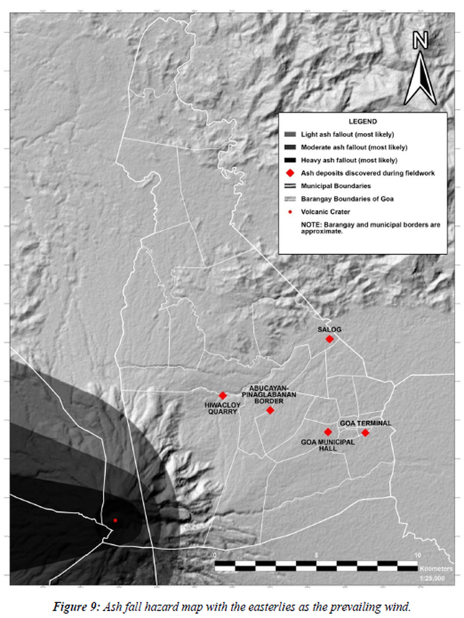
Figure in a thesis or dissertation
Ash fall hazard map with the easterlies as the prevailing wind
Figure 9 in: Daita, T.J.E. (2020). Preliminary Volcanic Hazard Assessment of Goa, Camarines Sur, Philippines. Thesis, Partido State University, Goa, Camarines Sur, Philippines.
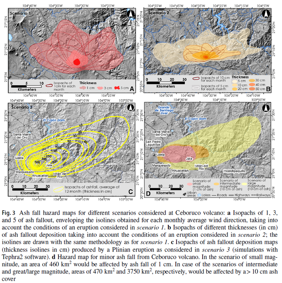
Figure in a journal article
Ash fall hazard maps for different scenarios considered at Ceboruco volcano
Figure 3 in: Sieron, K., Ferrés, D., Siebe, C., Constantinescu, R., Capra, L., Connor, C., Connor, L., Groppelli, G. & Zuccolotto, K.G. (2019). Ceboruco hazard map: part II—modeling volcanic phenomena and construction of the general hazard map. Natural Hazards, 96(2), p. 893-933. https://doi.org/10.1007/s11069-019-03577-5
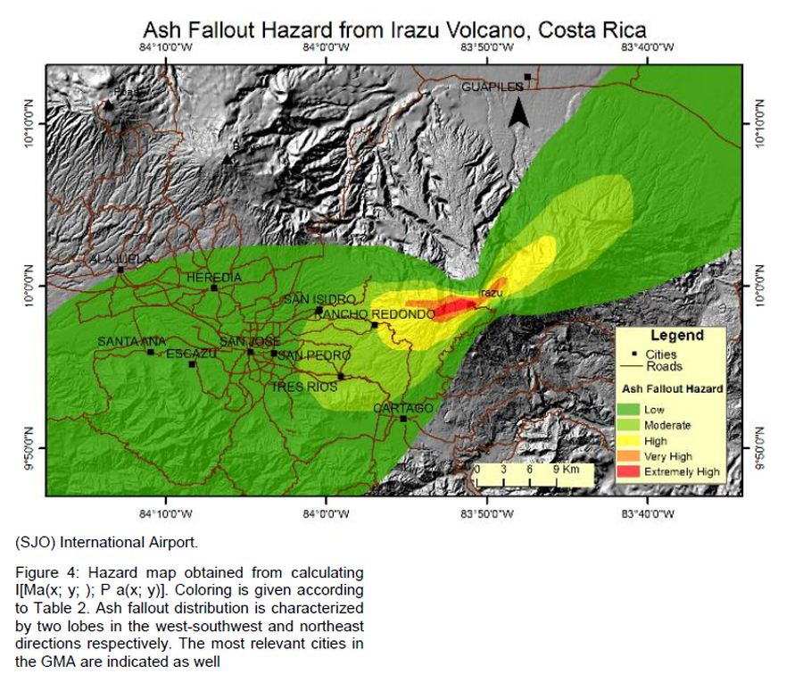
Figure in a journal article
Ash Fallout Hazard from Irazu Volcano, Costa Rica
Figure 4 in: Barrantes, G., Núñez, S., & Malavassi, E. (2018). Ash fallout hazard from Irazú volcano, Costa Rica. Revista Geográfica de Chile Terra Australis, 54(1), 13-25. https://doi.org/10.23854/07199562.2018541Barrantes13