
Advanced Search for Maps
Showing 11-20 of 256
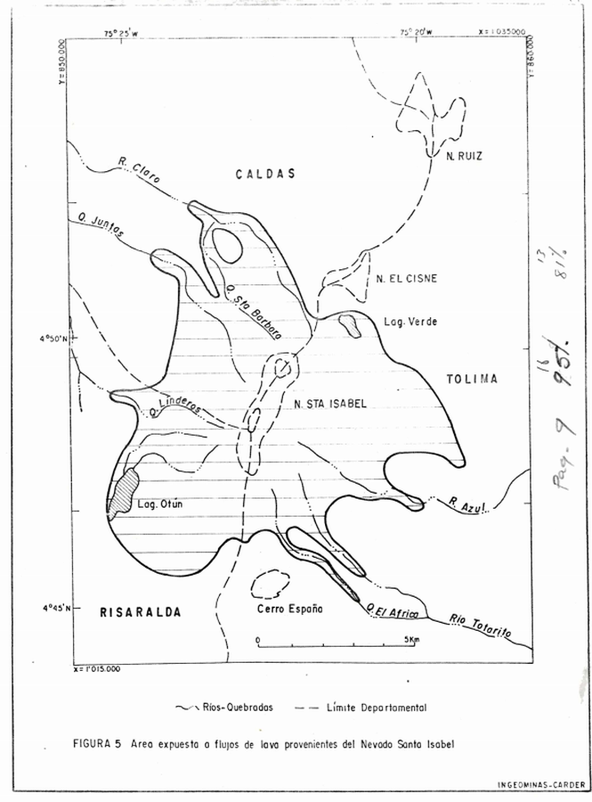
Official, Figure in hazard assessment
Area expuesta a flujos de lava provenientes del Nevado Santa Isabel
(Area exposed to lava flows from Nevado de Santa Isabel)
Figure 5 in: Instituto de Investigaciones en Geociencias, Mineria y Quimica (INGEOMINAS). (1993). Mapa Preliminar de Amenaza Volcanica Potencial Complejo de Domos Santa Isabel, Cordillera Central de Colombia. Ibague.
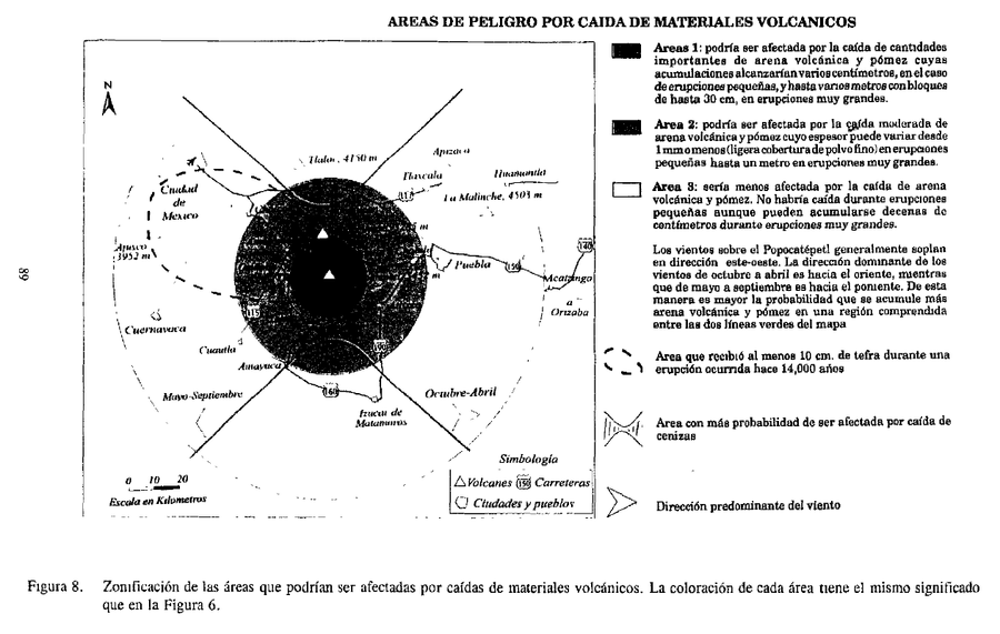
Official, Figure in hazard assessment
Areas de Peligro por Caida de Materiales Volcanicos
(Hazard Areas for Falling Volcanic Materials)
Figure 8 in: Macías J.L., Carrasco, G. Siebe, C. (1995). Zonificación de peligros volcánicos del Popocatepetl. Capitulo III Riesgos y Mapeo.
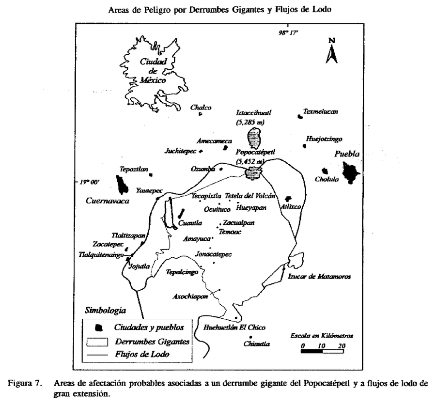
Official, Figure in hazard assessment
Areas de Peligro por Derrumbes Gigantes y Flujos de Lodo
(Hazard Areas for Giant Landslides and Mudflows)
Figure 7 in: Macías J.L., Carrasco, G. Siebe, C. (1995). Zonificación de peligros volcánicos del Popocatepetl. Capitulo III Riesgos y Mapeo.

Official, Figure in hazard assessment
Areas likely to be affected by lahars, lahar-runout flows, and floods during eruptions of Redoubt Volcano.
Figure 9 in: Waythomas, C.F., Dorava, J.M., Miller, T.P., Neal, C.A. & McGimsey, R.G. (1997). Preliminary volcano-hazard assessment for Redoubt Volcano, Alaska. U.S. Geological Survey, Open-File Report 97-857, 40 p., 1 plate. https://doi.org/10.3133/ofr97857
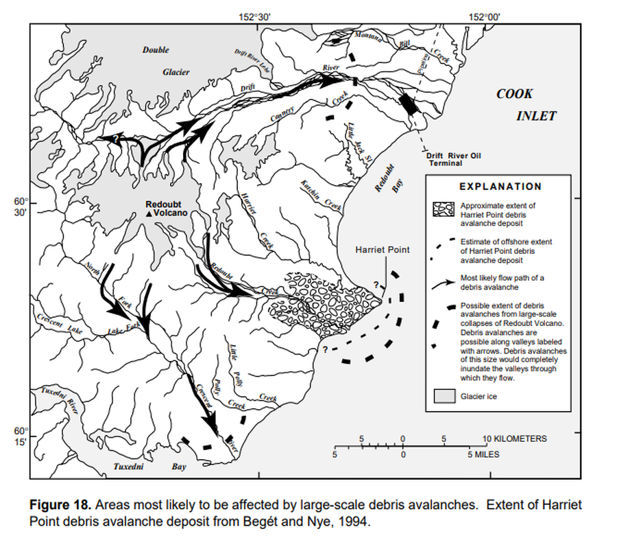
Official, Figure in hazard assessment
Areas most likely to be affected by large-scale debris avalanches
Figure 18 in: Waythomas, C.F., Dorava, J.M., Miller, T.P., Neal, C.A. & McGimsey, R.G. (1997). Preliminary volcano-hazard assessment for Redoubt Volcano, Alaska. U.S. Geological Survey, Open-File Report 97-857, 40 p., 1 plate. https://doi.org/10.3133/ofr97857
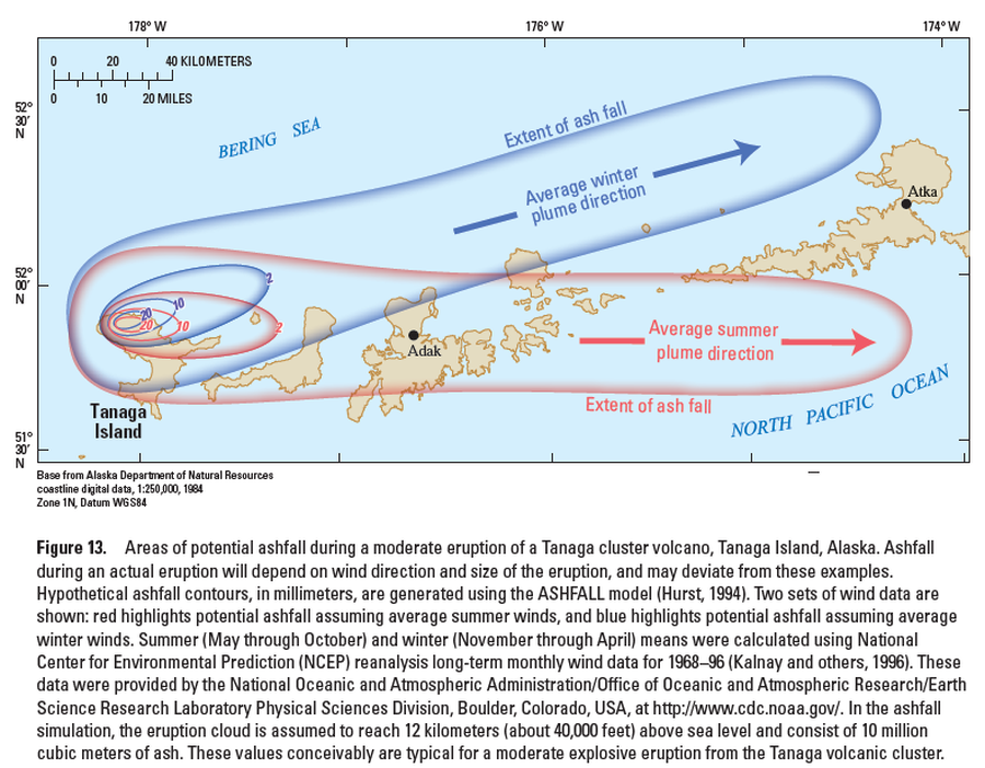
Official, Figure in hazard assessment
Areas of potential ashfall during a moderate eruption of a Tanaga cluster volcano, Tanaga Island, Alaska
Figure 13 in: Coombs, M.L., McGimsey, R.G. & Browne, B.L. (2007). Preliminary volcano-hazard assessment for the Tanaga volcanic cluster, Tanaga Island, Alaska. U.S. Geological Survey, Scientific Investigations Report 2007-5094, 41 p., 1 plate. https://doi.org/10.3133/sir20075094
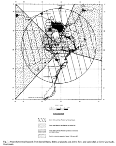
Figure in a journal article
Areas of potential hazards from lateral blasts, debris avalanche and debris flow, and tephra fall at Cerro Quemado, Guatemala.
Figure 7 in: Conway, F. M., Vallance, J. W., Rose, W. I., Johns, G. W., & Paniagua, S. (1992). Cerro Quemado, Guatemala: the volcanic history and hazards of an exogenous volcanic dome complex. Journal of Volcanology and Geothermal Research, 52(4), p. 303-323. https://doi.org/10.1016/0377-0273(92)90051-E
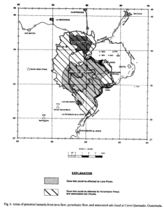
Figure in a journal article
Areas of potential hazards from lava flow, pyroclastic flow, and associated ash cloud at Cerro Quemado, Guatemala.
Figure 6 in: Conway, F. M., Vallance, J. W., Rose, W. I., Johns, G. W., & Paniagua, S. (1992). Cerro Quemado, Guatemala: the volcanic history and hazards of an exogenous volcanic dome complex. Journal of Volcanology and Geothermal Research, 52(4), p. 303-323. https://doi.org/10.1016/0377-0273(92)90051-E
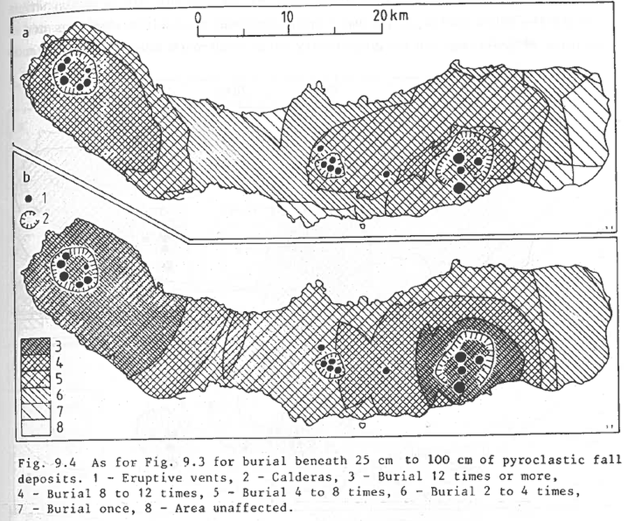
Figure in a journal article
As for Fig. 9.3 for burial beneath 25 to 100 cm of pyroclastic fall deposits
Figure 9.4 in: Booth, B., Croasdale, R., & Walker, G.L. (1983). Volcanic hazard on Sao Miguel, Azores. In: Tazieff, H. & Sabroux, J.C. (eds.). Forecasting Volcanic Events. Elsevier, Amsterdam. p. 99-109.
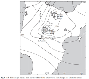
Official, Figure in a journal article
Ash thickness (in metres) from our model for 1 Ma of eruptions from Taupo and Okataina centres
Figure 9 in: Hurst, T. & Smith, W. (2010). Volcanic ashfall in New Zealand–probabilistic hazard modelling for multiple sources. New Zealand Journal of Geology and Geophysics, 53(1), 1-14. https://doi.org/10.1080/00288301003631129