
Advanced Search for Maps
Showing 51-60 of 256
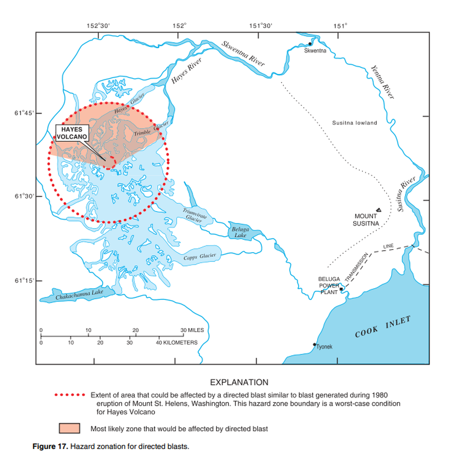
Official, Figure in hazard assessment
Hazard zonation for directed blasts
Figure 17 in: Waythomas, C.F. & Miller, T.P. (2002). Preliminary volcano-hazard assessment for Hayes Volcano, Alaska. U.S. Geological Survey, Open-File Report 02-072, 33 p., 1 plate. https://doi.org/10.3133/ofr0272

Official, Figure in hazard assessment
Hazard Zonation for Lava Flow
Figure 23 in: Waythomas, C.F., Miller, T.P. & Mangan, M.T. (2006). Preliminary volcano hazard assessment for the Emmons Lake Volcanic Center, Alaska. U.S. Geological Survey, Scientific Investigations Report 2006-5248, 33 p.
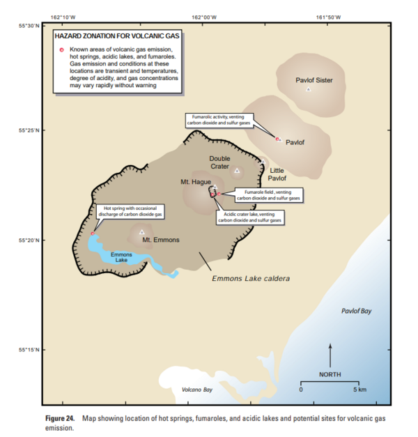
Official, Figure in hazard assessment
Hazard Zonation for Volcanic Gas
Figure 24 in: Waythomas, C.F., Miller, T.P. & Mangan, M.T. (2006). Preliminary volcano hazard assessment for the Emmons Lake Volcanic Center, Alaska. U.S. Geological Survey, Scientific Investigations Report 2006-5248, 33 p.
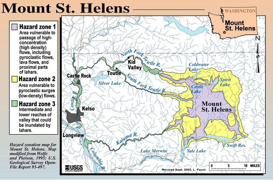
Official, Figure on website
Hazard Zonation Map for Mount St. Helens
Faust, L. (2003). Hazard zonation map for Mount St. Helens. U.S. Geological Survey. (Simplified from: Wolfe & Pierson 1995) (Reprinted in: Bluth, G. (Year Unknown). Mt. St. Helens Activity Update (+ 2004 events). Michigan Technological University, GE4150 Lecture. https://pages.mtu.edu/~gbluth/Teaching/GE4150/lecture_pdfs/L11_msh_seismic.pdf#page=2)
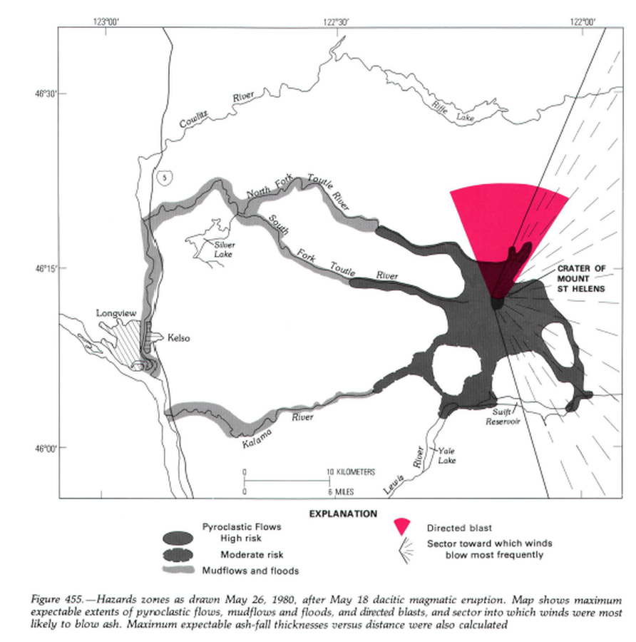
Official, Unknown format
Hazard zones as drawn May 26, 1980, after May 18 dacitic magmatic eruption.
Figure 455 in: Miller, C.D., Mullineaux, D.R. & Crandell, D.R. (1981). Hazards assessments at Mount St. Helens. In: Lipman, P. W. & Mullineaux, D. R. (Eds.) The 1980 eruptions of Mount St. Helens, Washington. U.S. Geological Survey, Professional Paper 1250, p. 789-802. https://doi.org/10.3133/pp1250
Official, Figure in hazard assessment
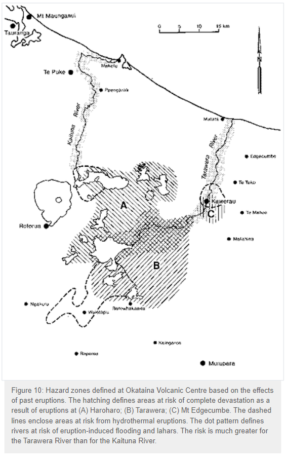
Hazard zones defined at Okataina Volcanic Centre based on the effects of past eruptions
Figure 10 in: Nairn, I.A. (1993). Volcanic hazards at Okataina Centre. 3rd ed. Ministry of Civil Defence, Palmerston North, NZ. Volcanic hazards information series 2. 29 p. Reproduced on website: https://www.gns.cri.nz/Home/Learning/Science-Topics/Volcanoes/New-Zealand-Volcanoes/Volcano-Geology-and-Hazards/Okataina-Volcanic-Centre-Geology
Official, Figure in hazard assessment
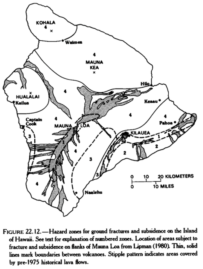
Hazard zones for ground fractures and subsidence on the Island of Hawaii
Figure 22.12 in: Mullineaux, D.R., Peterson, D.W., & Crandell, D.R. (1987). Volcanic hazards in the Hawaiian Islands. In: Decker, R.W., Wright, T.L., & Stauffer, P.H. (Eds.) Volcanism in Hawaii. US Geological Survey Professional Paper 1350, Chapter 22, p. 599-621. https://doi.org/10.3133/pp1350
Official, Map in a booklet, long fact-sheet, or handbook
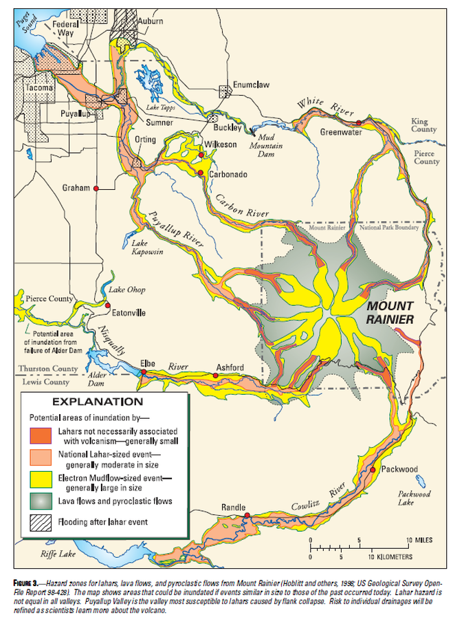
Hazard zones for lahars, lava flows, and pyroclastic flows from Mount Rainier
Figure 3 in: Driedger, C.L. & Scott, K.M. (2002). Mount Rainier: learning to live with volcanic risk. U.S. Geological Survey, Fact Sheet 034-02, 4 p. https://doi.org/10.3133/fs03402
Official, Figure in hazard assessment
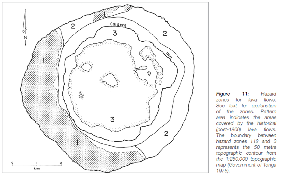
Hazard zones for lava flows
Figure 11 in: Taylor, P.W. (2016). Niuafo’ou, Tonga: Volcanic Hazards and the Risk From Future Activity. In: Taylor, P.W. (Ed.) Volcanic Hazards and Emergency Management in the Southwest Pacific, SPC Technical Bulletin, SPC00017, p. 132-150
Hualalai, United States
Official, Map in a booklet, long fact-sheet, or handbook
Hazard zones for lava flows on Hualalai
Page 30 in: U.S. Geological Survey (USGS). (1997). Volcanic and Seismic Hazards on the Island of Hawaii. U.S. Geological Survey, Unumbered Series, 48 p. https://doi.org/10.3133/7000036 (Simplified from: Wright 1992)