
Advanced Search for Maps
Showing 41-50 of 508
Official, Map sheet or poster
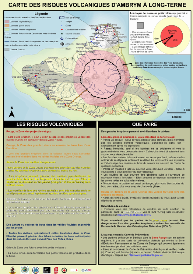
Carte des Risques Volcaniques d'Ambrym à Long-terme
(Ambrym Long-Term Background Volcanic Hazards Map)
Vanuatu Meteorology & Geo-Hazards Department. (2016). Carte des Risques Volcaniques d'Ambrym à Long-terme. Government of Vanuatu, Vanuatu Meteorology & Geo-Hazards Department, Vanuatu National Disaster Risk Management Office, New Zealand Foreign Affairs & Trade Aid Programme, GNS Science, The Vanuatu Red Cross Society, Croix Rouge Francaise, USAID.
Official, Map sheet or poster
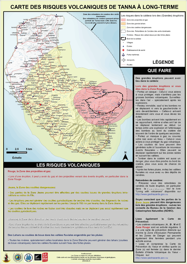
Carte des Risques Volcaniques de Tanna à Long-Terme
(Tanna Long-Term Background Volcanic Hazards Map)
Vanuatu Meteorology & Geo-Hazards Department. (2016). Carte des Risques Volcaniques de Tanna à Long-Terme. Government of Vanuatu, Vanuatu Meteorology & Geo-Hazards Department, Vanuatu National Disaster Risk Management Office, New Zealand Foreign Affairs & Trade Aid Programme, GNS Science.
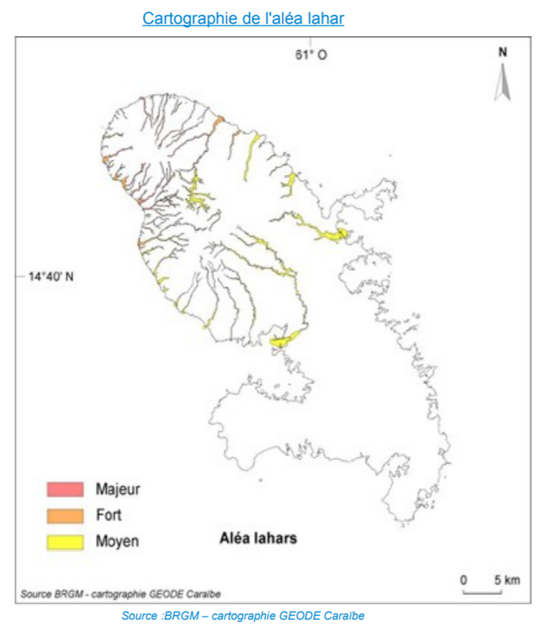
Official, Figure in hazard assessment
Cartographie de l'Aléa Lahar
(Map of Lahar Hazards)
Page 79 in: Préfet de la Martinique. (2014). Dossier Départemental des Risques Majeurs en Martinique. DDRM 972.
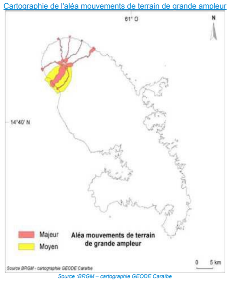
Official, Figure in hazard assessment
Cartographie de l'Aléa Mouvements de Terrain de Grande Ampleur
(Map of the Hazards from Large-scale Land Movements)
Page 72 in: Préfet de la Martinique. (2014). Dossier Départemental des Risques Majeurs en Martinique. DDRM 972.
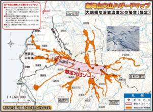
Official, Map in a booklet, long fact-sheet, or handbook
Chokaisan Hazard Map - In case of large scale lava flow eruption
Page 12 in: Volcano Disaster Management Councils of Chokaisan. (2019). Chokaisan Volcanic Disaster Prevention Map.
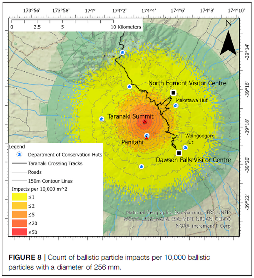
Figure in a journal article
Count of ballistic particle impacts per 10,000 ballistic particles with a diameter of 256 mm
Figure 8 in: Mead, S., Procter, J., Bebbington, M., & Rodriguez-Gomez, C. (2022). Probabilistic Volcanic Hazard Assessment for National Park Infrastructure Proximal to Taranaki Volcano (New Zealand). Frontiers in Earth Science, 435. https://doi.org/10.3389/feart.2022.832531
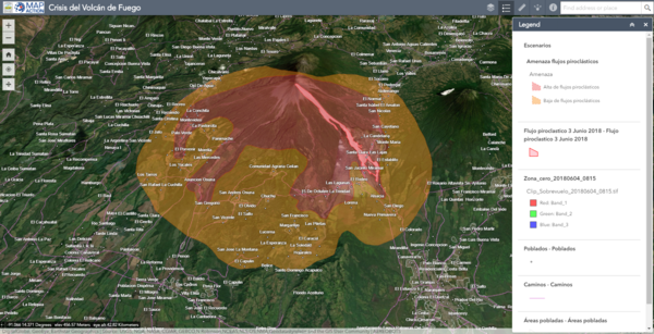
Official, Interactive web-based map
Crisis del Volcán de Fuego
(Fuego Volcano Crisis)
Instituto Nacional de Sismología, Vulcanologia, Meteorologia e Hidrología (INSIVUMEH), Map Action, Volcano Disaster Assistance Program (VDAP), U.S. Geological Survey (USGS), University of Edinburgh & Michigan Technological University. (2018). Crisis del Volcan Fuego.
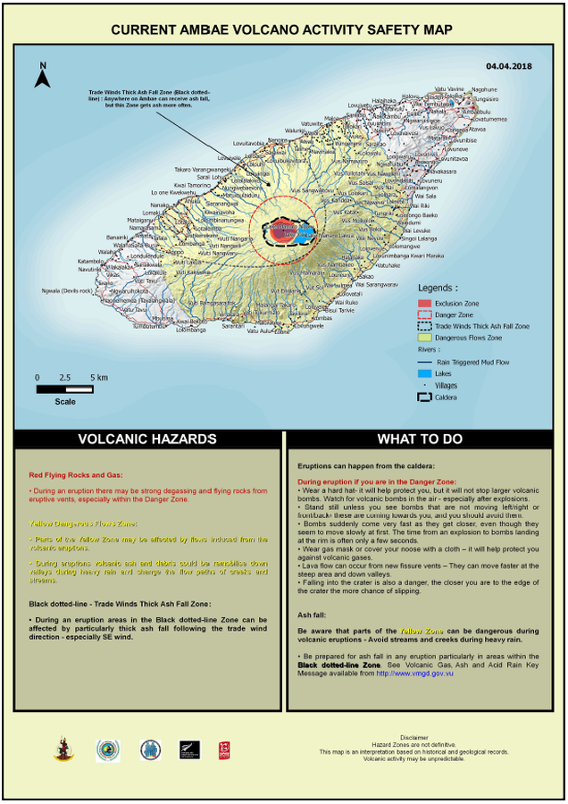
Official, Map in an information statement
Current Ambae Volcano Activity Safety Map
Vanuatu Meteorology & Geo-Hazards Department. (2018). Current Ambae Volcano Activity Safety Map 04.04.2018. Government of Vanuatu, Vanuatu Meteorology & Geo-Hazards Department, Vanuatu National Disaster Risk Management Office, New Zealand Foreign Affairs & Trade Aid Programme, GNS Science.
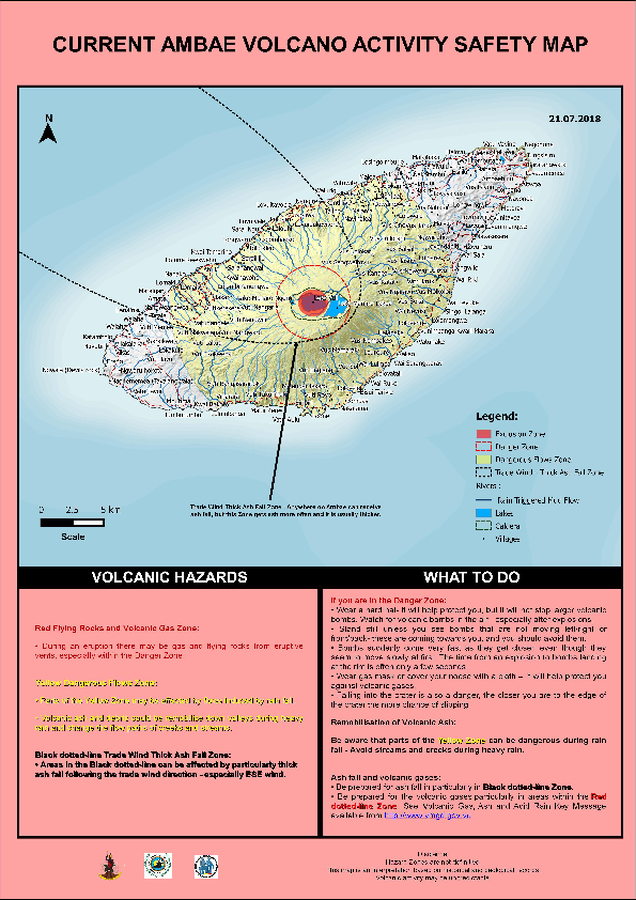
Official, Map in an information statement
Current Ambae Volcano Activity Safety Map
Vanuatu Meteorology & Geo-Hazards Department. (2018). Current Ambae Volcano Activity Safety Map 21.07.2018. Government of Vanuatu, Vanuatu Meteorology & Geo-Hazards Department, Vanuatu National Disaster Risk Management Office, New Zealand Foreign Affairs & Trade Aid Programme, GNS Science.
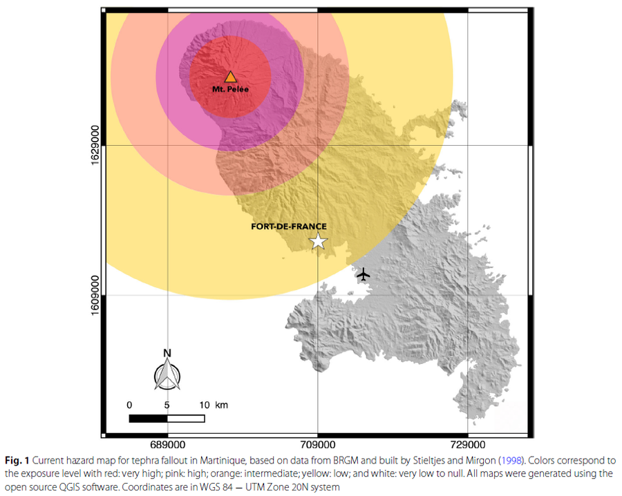
Figure in a journal article
Current hazard map for tephra fallout in Martinique
Figure 1 in: Michaud-Dubuy, A., Carazzo, G., & Kaminski, E. (2021). Volcanic hazard assessment for tephra fallout in Martinique. Journal of Applied Volcanology, 10(1), 1-20. https://doi.org/10.1186/s13617-021-00106-7. (Modified from: Stieltjes & Mirgon 1998)