
Advanced Search for Maps
Showing 51-60 of 70
Official, Figure on website
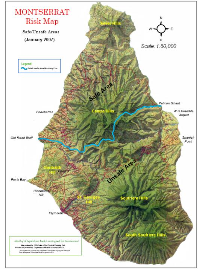
Montserrat Risk Map Safe/Unsafe Areas (January 2007)
Montserrat Volcano Observatory (MVO). (2007). Montserrat Risk Map Safe/Unsafe Areas (January 2007). Montserrat Volcano Observatory. Risk Map - Janary 2007. https://web.archive.org/web/20070219015306fw_/http://www.mvo.ms/0701%20Risk%20Map.htm
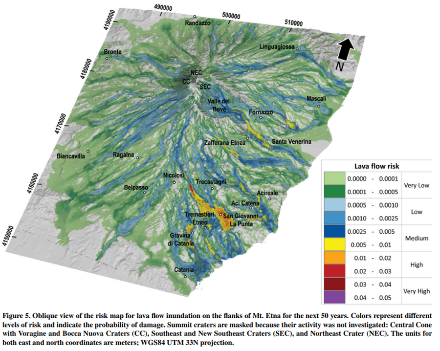
Figure in a journal article
Oblique view of the risk map for lava flow inundation on the flanks of Mt. Etna for the next 50 years
Figure 5 in: Del Negro, C., Cappello, A., Bilotta, G., Ganci, G., Hérault, A., & Zago, V. (2020). Living at the edge of an active volcano: Risk from lava flows on Mt. Etna. GSA Bulletin, 132(7-8), 1615-1625. https://doi.org/10.1130/B35290.1
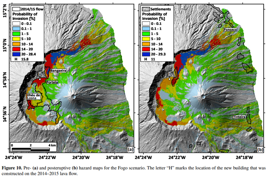
Figure in a journal article
Pre- and posteruptive hazard maps for the Fogo scenario
Figure 10 in: Richter, N., Favalli, M., de Zeeuw-van Dalfsen, E., Fornaciai, A., da Silva Fernandes, R. M., Pérez, N. M., Levy, J., Victoria, S.S., & Walter, T. R. (2016). Lava flow hazard at Fogo Volcano, Cabo Verde, before and after the 2014–2015 eruption. Natural Hazards and Earth System Sciences, 16(8), 1925-1951. https://doi.org/10.5194/nhess-16-1925-2016
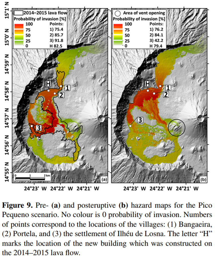
Figure in a journal article
Pre- and posteruptive hazard maps for the Pico Pequeno scenario
Figure 9 in: Richter, N., Favalli, M., de Zeeuw-van Dalfsen, E., Fornaciai, A., da Silva Fernandes, R. M., Pérez, N. M., Levy, J., Victoria, S.S., & Walter, T. R. (2016). Lava flow hazard at Fogo Volcano, Cabo Verde, before and after the 2014–2015 eruption. Natural Hazards and Earth System Sciences, 16(8), 1925-1951. https://doi.org/10.5194/nhess-16-1925-2016
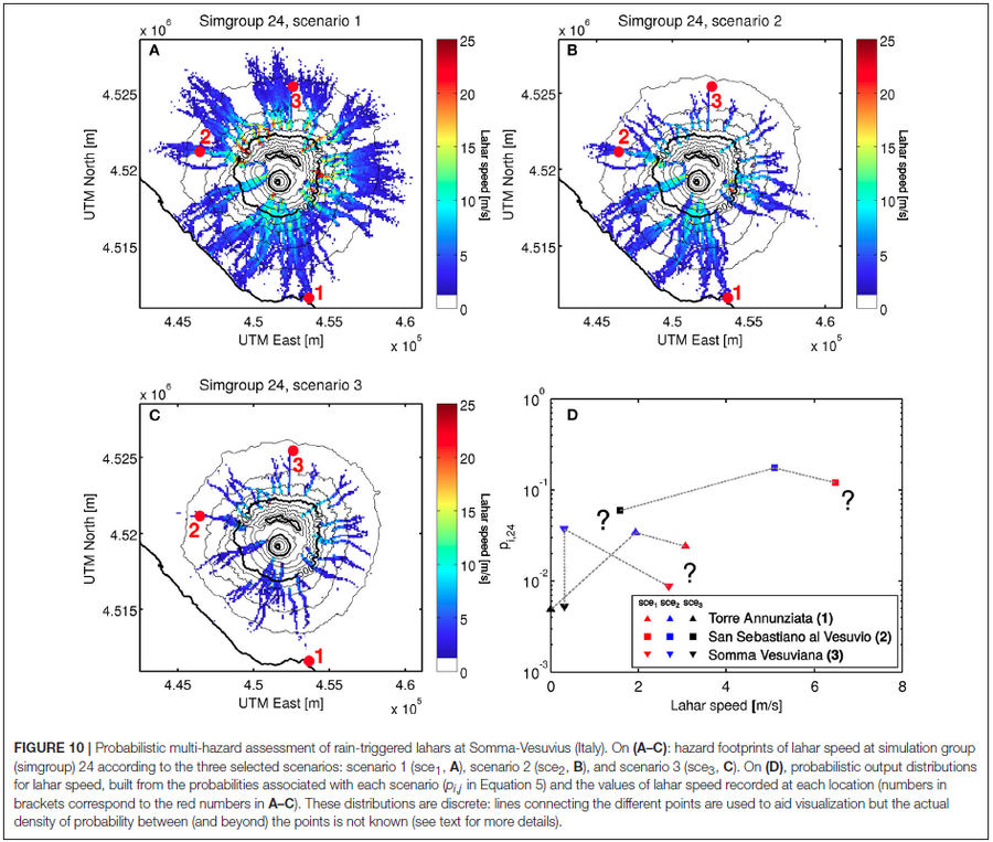
Figure in a journal article
Probabilistic multi-hazard assessment of rain-triggered lahars at Somma-Vesuvius (Italy).
Figure 10 in: Tierz, P., Woodhouse, M.J., Phillips, J.C., Sandri, L., Selva, J., Marzocchi, W., & Odbert, H.M. (2017). A framework for probabilistic multi-hazard assessment of rain-triggered lahars using Bayesian belief networks. Frontiers in Earth Science, 5 (73). https://doi.org/10.3389/feart.2017.00073
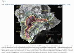
Figure in a journal article
Results for channel-fed flows superimposed on a portion of a cloud-free Landsat ETM+ image
Figure 4 in: Rowland, S. K., Garbeil, H., & Harris, A. J. (2005). Lengths and hazards from channel-fed lava flows on Mauna Loa, Hawai ‘i, determined from thermal and downslope modeling with FLOWGO. Bulletin of Volcanology, 67(7), 634-647. https://doi.org/10.1007/s00445-004-0399-x
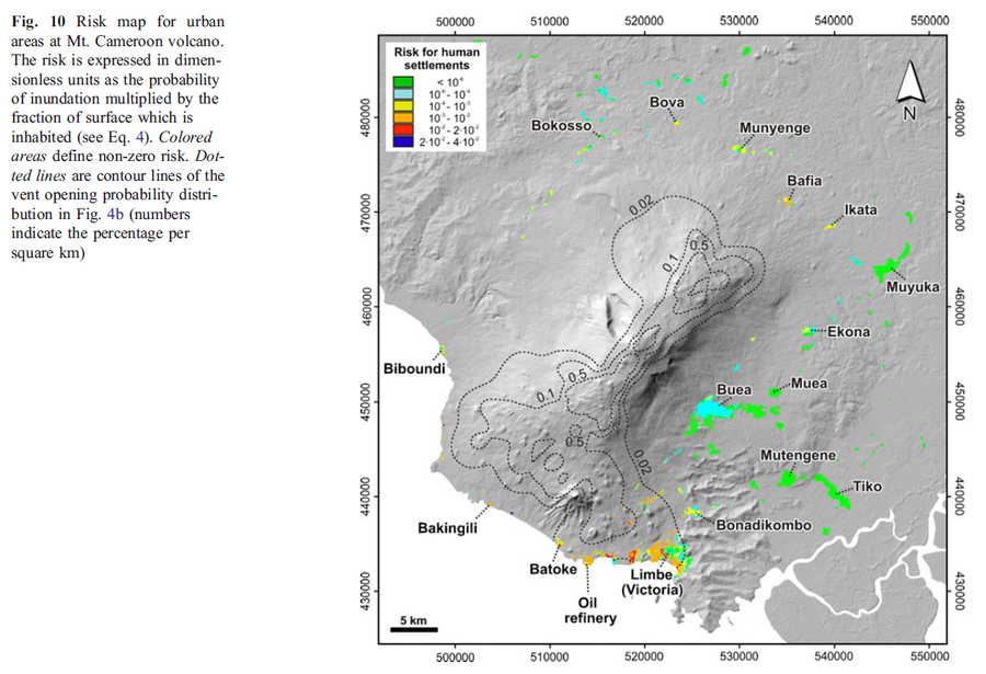
Figure in a journal article
Risk map for urban areas at Mt. Cameroon volcano
Figure 10 in: Favalli, M., Tarquini, S., Papale, P., Fornaciai, A., & Boschi, E. (2012). Lava flow hazard and risk at Mt. Cameroon volcano. Bulletin of Volcanology, 74(2), 423-439. https://doi.org/10.1007/s00445-011-0540-6
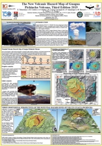
Official, Figure in a conference presentation
The New Volcanic Hazard Map of Guagua Pichincha Volcano, Third Edition 2019
Telenchana, E., Córdova, M., Mothes, P., Espín, P., Samaniego, P., Bernard, B., Vallejo, S., & Proaño A. (2019). The new potential volcanic hazard map of Guagua Pichincha Volcano, Third Edition 2019. 8th International Symposium on Andean Geodynamics (ISAG).
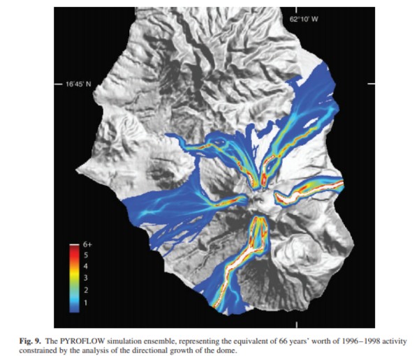
Figure in a journal article
The PYROFLOW simulation ensemble, representing the equivalent of 66 years' worth of 1996-1998 activity constrained by the analysis of the directional growth of the dome.
Figure 9 in: Wadge, G. (2009). Assessing the pyroclastic flow hazards from dome collapse at Soufriere Hills Volcano, Montserrat. In: Thordarson, S., Self, S., Larsen, G., Rowland, S.K., & Hoskuldsson, A. (Eds.) Studies in Volcanology: The Legacy of George Walker. IAVCEI, Special Publications, 2, p. 211-224. https://doi.org/10.1144/IAVCEl002.11
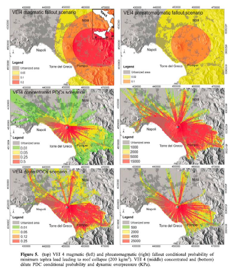
Figure in a journal article
VEI 4 Magmatic fallout scenario, VEI 4 phreatomagmatic fallout scenario, VEI 4 concentrated PDC scenario, VEI 4 dilute PDC scenario
Figure 5 in: Mastrolorenzo, G., & Pappalardo, L. (2010). Hazard assessment of explosive volcanism at Somma‐Vesuvius. Journal of Geophysical Research: Solid Earth, 115(B12). https://doi.org/10.1029/2009JB006871