
Advanced Search for Maps
Showing 21-30 of 148
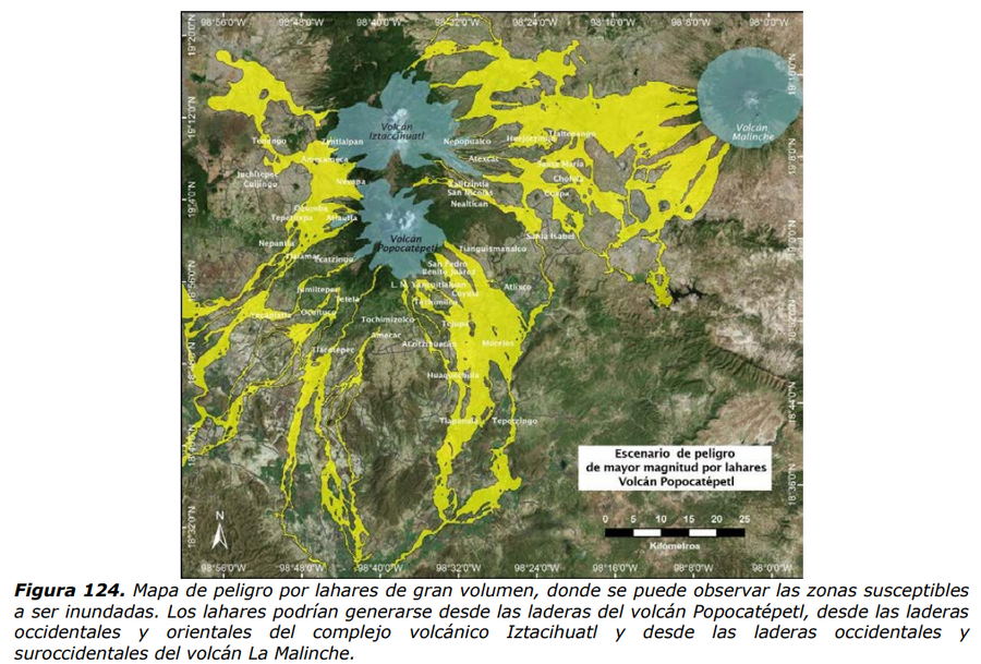
Official, Figure in hazard assessment
Escenario peligro de mayor magnitud por lahares Volcán Popocatépetl
(Hazard scenario of greater magnitude due to lahars Popocatépetl Volcano)
Figure 124 in: Martin Del Pozzo, A.L, Alatorre Ibargüengoitia M., Arana Salinas L., Bonasia R., Capra Pedol L., Cassata W., Cordoba G., Cortés Ramos J., Delgado Granados H., Ferrés López M.D., Fonseca Álvarez R., García Reynoso J.A., Gisbert G., Guerrero López D.A., Jaimes Viera M., Macías Vázquez J.L., Nieto Obregon J., Nieto Torres A., Paredes Ruiz P.A., Portocarrero Martínez J., Renne P., Rodríguez Espinosa D.M., Salinas Sánchez S., Siebe Grabach C., & Tellez Ugalde E. (2017). Estudios geológicos y actualización del mapa de peligros del volcán Popocatépetl. Memoria técnica del mapa de peligros del volcán Popocatépetl. Instituto de Geofísica, Universidad Nacional Autónoma de México (UNAM).
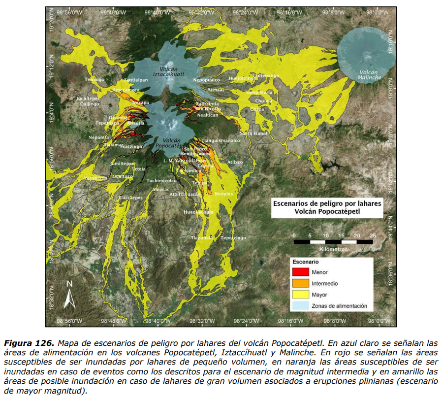
Official, Figure in hazard assessment
Escenarios de peligro por lahares Volcán Popocatépetl
(Hazard scenarios due to lahars Popocatépetl Volcano)
Figure 126 in: Martin Del Pozzo, A.L, Alatorre Ibargüengoitia M., Arana Salinas L., Bonasia R., Capra Pedol L., Cassata W., Cordoba G., Cortés Ramos J., Delgado Granados H., Ferrés López M.D., Fonseca Álvarez R., García Reynoso J.A., Gisbert G., Guerrero López D.A., Jaimes Viera M., Macías Vázquez J.L., Nieto Obregon J., Nieto Torres A., Paredes Ruiz P.A., Portocarrero Martínez J., Renne P., Rodríguez Espinosa D.M., Salinas Sánchez S., Siebe Grabach C., & Tellez Ugalde E. (2017). Estudios geológicos y actualización del mapa de peligros del volcán Popocatépetl. Memoria técnica del mapa de peligros del volcán Popocatépetl. Instituto de Geofísica, Universidad Nacional Autónoma de México (UNAM).
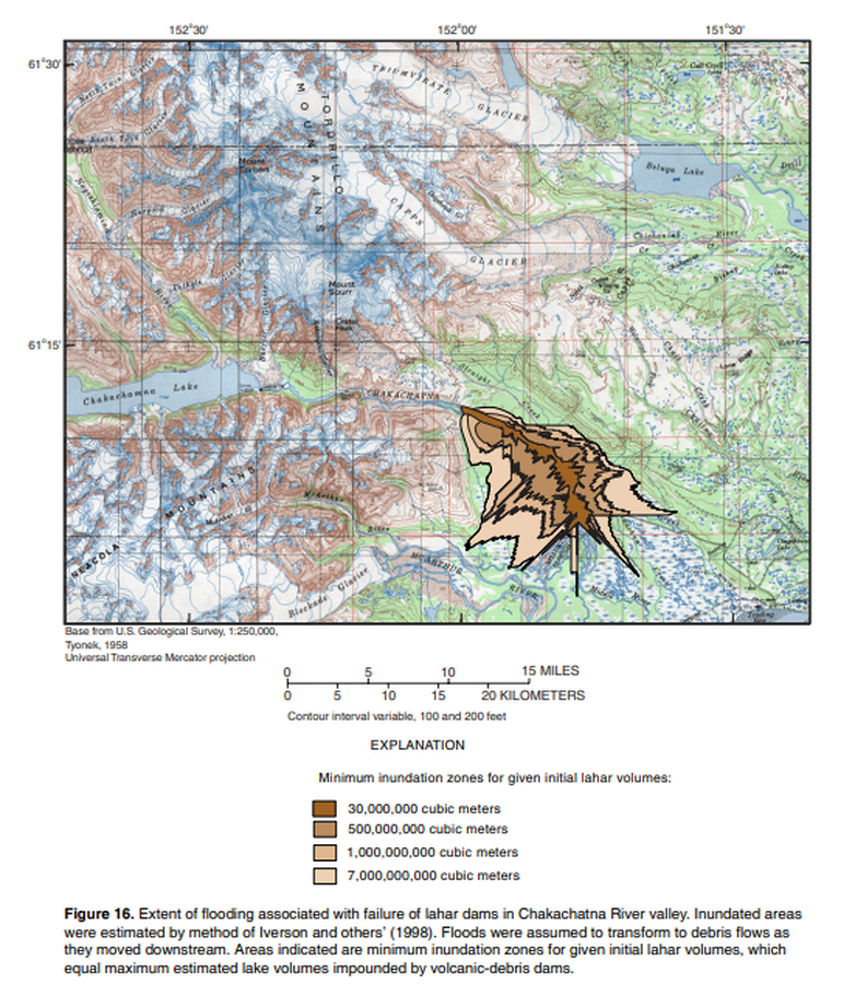
Official, Figure in hazard assessment
Extent of flooding associated with failure of lahar dams in Chakachatna River
Figure 16 in: Waythomas, C.F. & Nye, C.J. (2002). Preliminary volcano-hazard assessment for Mount Spurr Volcano, Alaska. U.S. Geological Survey, Open-File Report 2001-482, 40 p., 1 plate. https://doi.org/10.3133/ofr01482
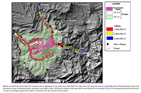
Figure in a journal article
Generalized hazard map of El Chichón volcano displayed on top of the post-1982 DEM
Figure 11 in: Macías, J. L., Capra, L., Arce, J. L., Espíndola, J. M., García-Palomo, A., & Sheridan, M. F. (2008). Hazard map of El Chichón volcano, Chiapas, México: Constraints posed by eruptive history and computer simulations. Journal of Volcanology and Geothermal Research, 175(4), 444-458. https://doi.org/10.1016/j.jvolgeores.2008.02.023
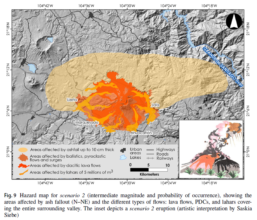
Figure in a journal article
Hazard map for scenario 2 (intermediate magnitude and probability of occurrence), showing the areas affected by ash fallout (N–NE) and the different types of flows: lava flows, PDCs, and lahars covering the entire surrounding valley
Figure 9 in: Sieron, K., Ferrés, D., Siebe, C., Constantinescu, R., Capra, L., Connor, C., Connor, L., Groppelli, G. & Zuccolotto, K.G. (2019). Ceboruco hazard map: part II—modeling volcanic phenomena and construction of the general hazard map. Natural Hazards, 96(2), p. 893-933. https://doi.org/10.1007/s11069-019-03577-5
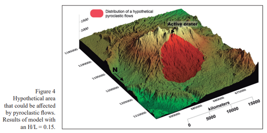
Figure in a journal article
Hypothetical area that could be affected by pyroclastic flows
Figure 4 in: Alpízar, Y., Fernández, M., Ramírez, C., & Arroyo, D. (2019). Hazard Map of Rincón de la Vieja Volcano, Costa Rica: Qualitative Integration of Computer Simulations and Geological Data. Anuario do Instituto de Geociencias, 42(3). http://dx.doi.org/10.11137/2019_3_474_488
Official (foreign agency), Insert/poster-size map with accompanying report
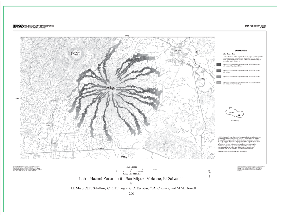
Lahar Hazard Zonation for San Miguel Volcano, El Salvador
Plate 1 in: Major, J.J., Schilling, S.P., Pullinger, C.R., Escobar, C.D., Chesner, C.A., & Howell, M.M. (2001). Lahar-Hazard Zonation for San Miguel Volcano, El Salvador. U.S. Geological Survey, Open-File Report 2001-395, 16 p., 1 plate. https://doi.org/10.3133/ofr01395
Official (foreign agency), Insert/poster-size map with accompanying report
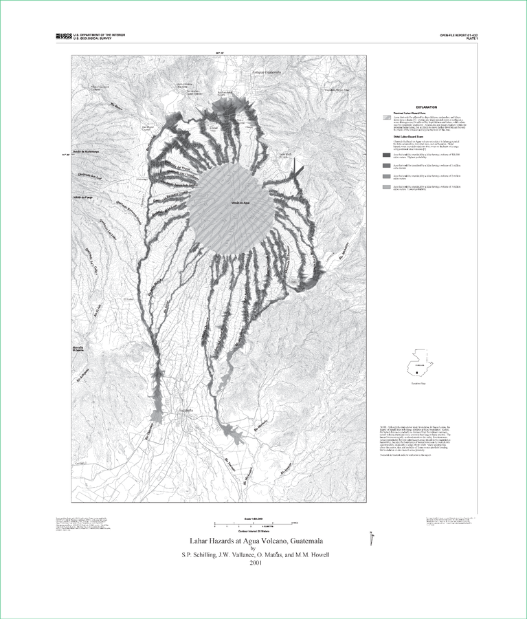
Lahar Hazards at Agua Volcano, Guatemala
Plate 1 in: Schilling, S.P., Vallance, J.W., Matías, O., & Howell, M.M. (2001). Lahar Hazards at Agua Volcano, Guatemala. U.S. Geological Survey, Open-File Report 01-432, 16 p., 1 plate. https://doi.org/10.3133/ofr01432
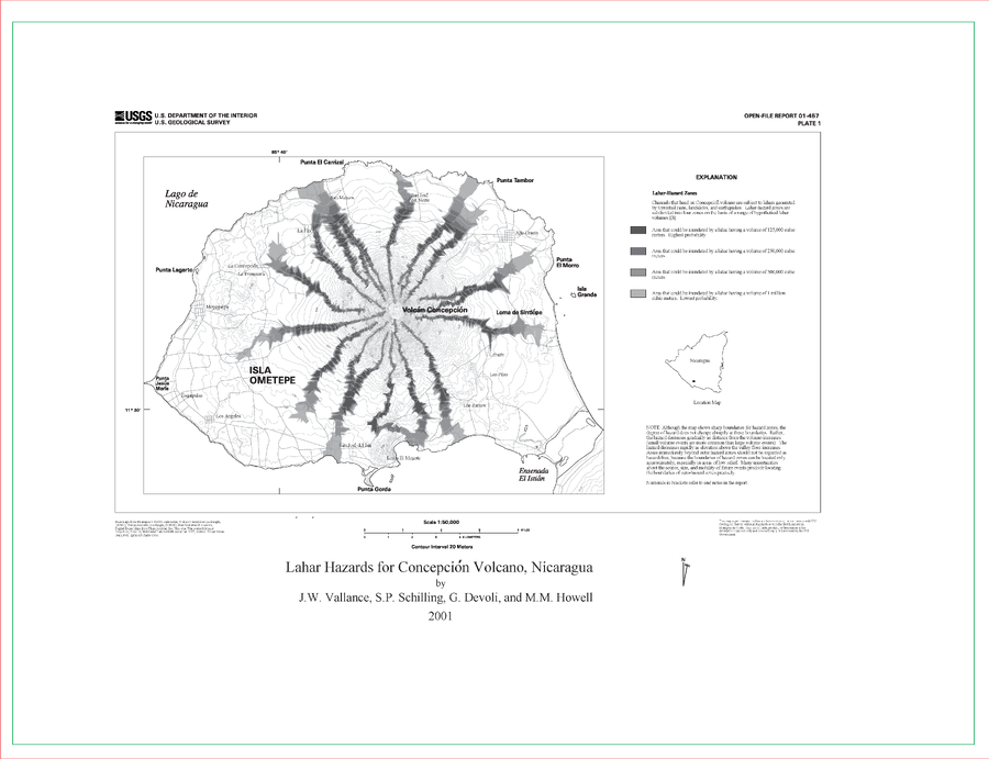
Official (foreign agency), Insert/poster-size map with accompanying report
Lahar Hazards for Concepción Volcano, Nicaragua
Plate 1 in: Vallance, J.W., Schilling, S.P., Devoli, G., & Howell, M.M. (2001). Lahar hazards at Concepción volcano, Nicaragua. U.S. Geological Survey, Open File Report 2001-457, 15 p., 1 plate. https://doi.org/10.3133/ofr01457
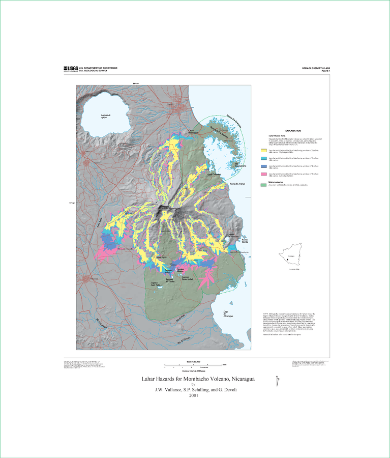
Official (foreign agency), Insert/poster-size map with accompanying report
Lahar Hazards for Mombacho Volcano, Nicaragua
Plate 1 (Color) in: Vallance, J.W., Schilling, S.P., Devoli, G. (2001). Lahar Hazards at Mombacho Volcano, Nicaragua. U.S. Geological Survey, Open-File Report 01-455, 16 p., 1 plate. https://doi.org/10.3133/ofr01455