
Advanced Search for Maps
Showing 51-60 of 236
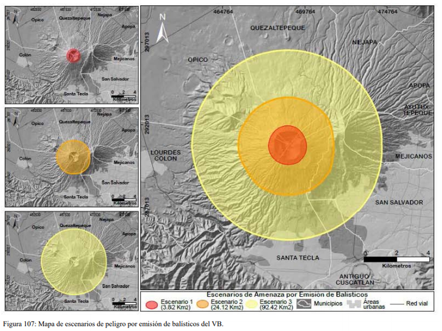
Figure in a thesis or dissertation
Escenarios de Amenaza por Emisión de Balísticos
(Ballistic Emission Threat Scenarios)
Figure 107 in: Ferrés López, M.D. (2014). Estratigrafía, Geología y Evaluación de Peligros Volcánicos del Complejo Volcánico de San Salvador (El Salvador). Doctoral Thesis, Universidad Autónoma de México, México.
Official, Map in a booklet, long fact-sheet, or handbook
Evacuation facilities
Asamayama Volcanic Disaster Prevention Committee. (2019). Asamayama Volcanic Disaster Prevention Map. Tsumagoi Village.
Soufrière St. Vincent, Saint Vincent and the Grenadines
Official, Figure on website
Fancy Community Multi-Hazard Map
The University of the West Indies Seismic Research Centre (UWI-SRC) and National Emergency Management Organization (NEMO). (2021). Fancy Community Multi-Hazard Map. https://uwiseismic.com/wp-content/uploads/2021/10/Fancy-Hazard-Map-scaled.jpg

Official, Map sheet or poster
Fuji City Volcano Disaster Prevention Map
Figure 6.3.13 in: Mt. Fuji Hazard Map Review Committee. (2004). Mt. Fuji Hazard Map Review Committee Report. June 2004. https://www.bousai.go.jp/kazan/fuji_map/pdf/report_200406.pdf
Official, Map sheet or poster
Fujisan Eruption Evacuation Route Map
Fujisan Eruption Evacuation Route Map
Official, Map sheet or poster
Fujiyoshida City Volcano Disaster Prevention Map
Figure 6.3.11 in: Mt. Fuji Hazard Map Review Committee. (2004). Mt. Fuji Hazard Map Review Committee Report. June 2004. https://www.bousai.go.jp/kazan/fuji_map/pdf/report_200406.pdf
Official, Insert/poster-size map with accompanying report
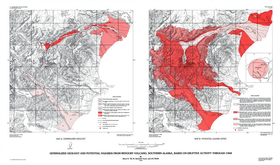
Generalized Geology and Potential Hazards from Redoubt Volcano, Southern Alaska, Based on Eruptive Activity Through 1968
Plate 1 in: Till, A.B., Yount, M.E., & Riehle, J.R. (1993). Redoubt Volcano, southern Alaska; a hazard assessment based on eruptive activity through 1968. U.S. Geological Survey, Bulletin 1996, 19 p., 1 plate. https://doi.org/10.3133/b1996
Official, Figure in hazard assessment
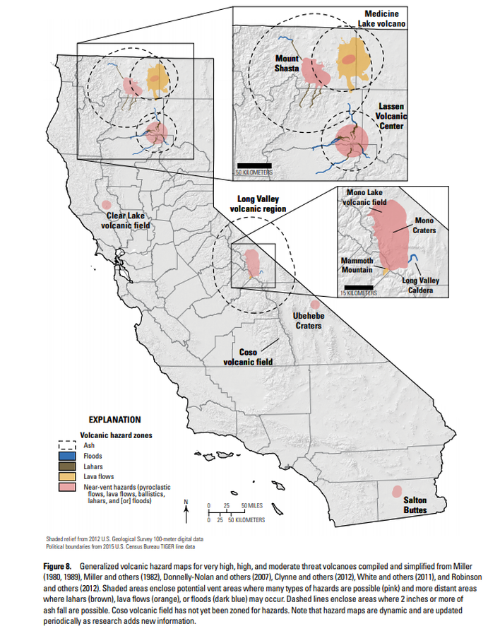
Generalized volcanic hazard maps for very high, high, and moderate threat volcanoes compiled and simplified from Miller (1980, 1989), Miller and others (1982), Donnelly-Nolan and others (2007), Clynne and others (2012), White and others (2011), and Robinson and others (2012)
Figure 8 in: Mangan, M., Ball, J., Wood, N., Jones, J.L., Peters, J., Abdollahian, N., Dinitz, L., Blankenheim, S., Fenton, J., & Pridmore, C. (2019). California’s exposure to volcanic hazards. U.S. Geological Survey Scientific Investigations Report 2018–5159, v. 1.1, 49 p. https://doi.org/10.3133/sir20185159
Soufrière St. Vincent, Saint Vincent and the Grenadines
Official, Figure on website
Georgetown Community Multi-Hazard Map
The University of the West Indies Seismic Research Centre (UWI-SRC) and National Emergency Management Organization (NEMO). (2021). Georgetown Community Multi-Hazard Map. https://uwiseismic.com/wp-content/uploads/2021/10/Georgetown-Hazard-Map-scaled.jpg
Official, Flyer, brochure, short fact-sheet, or handout
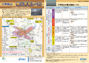
Hakkodasan Volcanic Alert Levels
Japan Meteorological Agency. (2019). Hakkodasan Volcanic Alert Levels. Volcano Monitoring and Warning Center, Volcano Division, Earthquake and Volcano Department.