
Advanced Search for Maps
Showing 51-60 of 899

Official, Figure in hazard assessment
Areas likely to be affected by lahars, lahar-runout flows, and floods during eruptions of Redoubt Volcano.
Figure 9 in: Waythomas, C.F., Dorava, J.M., Miller, T.P., Neal, C.A. & McGimsey, R.G. (1997). Preliminary volcano-hazard assessment for Redoubt Volcano, Alaska. U.S. Geological Survey, Open-File Report 97-857, 40 p., 1 plate. https://doi.org/10.3133/ofr97857
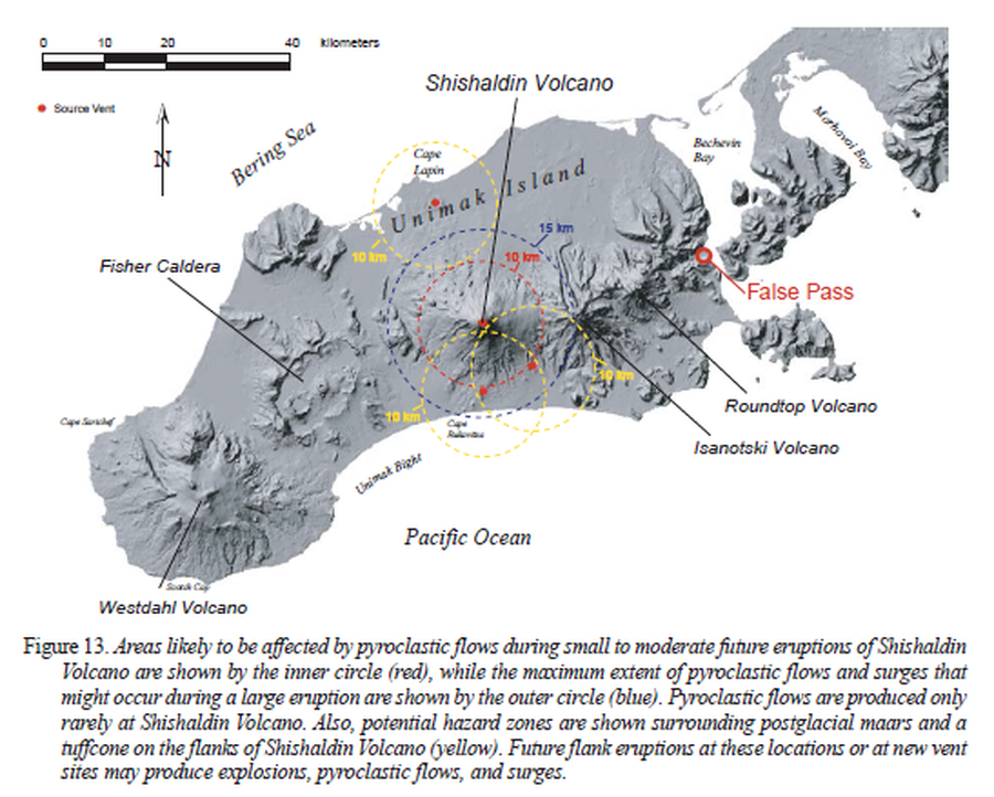
Official, Figure in hazard assessment
Areas likely to be affected by pyroclastic flows during small to moderate future eruptions of Shishaldin Volcano
Figure 13 in: Beget, J.E., Nye, C.J., Schaefer, J.R. & Stelling, P.L. (2003). Preliminary volcano-hazard assessment for Shishaldin Volcano, Alaska. Alaska Division of Geological & Geophysical Surveys, Report of Investigations 2002-4, 28 p., 1 sheet, scale 1:500,000. http://doi.org/10.14509/2872
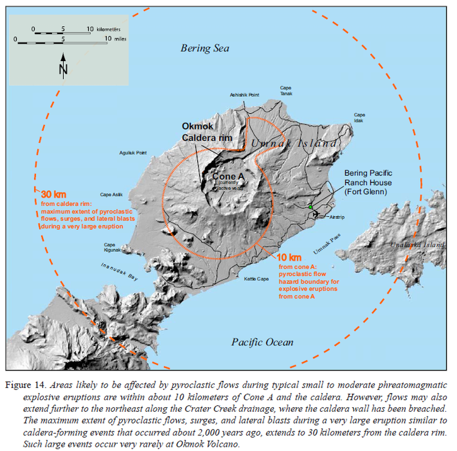
Official, Figure in hazard assessment
Areas likely to be affected by pyroclastic flows during typical small to moderate phreatomagmatic explosive eruptions
Figure 14 in: Beget, J.E., Larsen, J.F., Neal, C.A., Nye, C.J., & Schaefer, J.R. (2005). Preliminary volcano-hazard assessment for Okmok Volcano, Umnak Island, Alaska. Department of Natural Resources, Division of Geological & Geophysical Surveys (DGGS), Report of Investigation RI 2004-3, 32 p., 1 sheet, scale 1:150,000. http://doi.org/10.14509/7042
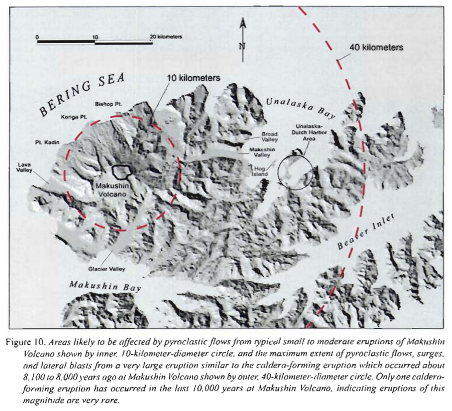
Official, Figure in hazard assessment
Areas likely to be affected by pyroclastic flows from typical small to moderate eruptions of Makushin
Figure 10 in: Beget, J.E., Nye, C.J. & Bean, K.W. (2000). Preliminary volcano-hazard assessment for Makushin Volcano, Alaska. Alaska Division of Geological & Geophysical Surveys, Report of Investigation 2000-4, 22 p., 1 sheet, scale 1:100,000.
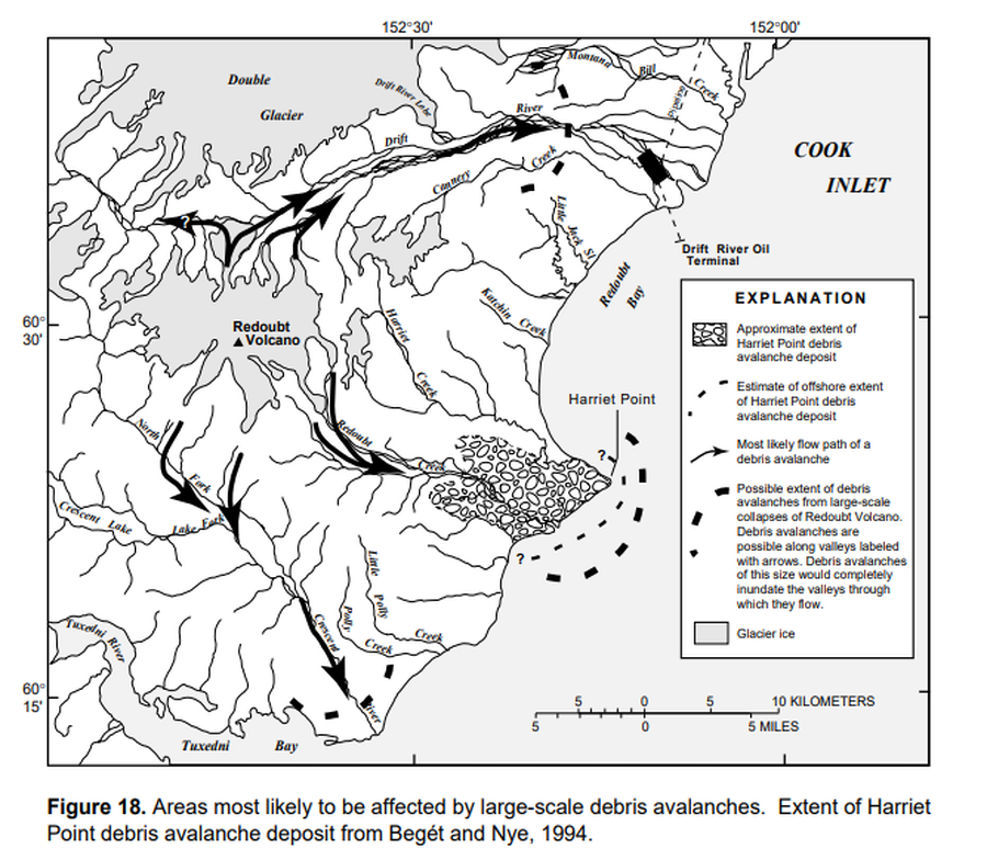
Official, Figure in hazard assessment
Areas most likely to be affected by large-scale debris avalanches
Figure 18 in: Waythomas, C.F., Dorava, J.M., Miller, T.P., Neal, C.A. & McGimsey, R.G. (1997). Preliminary volcano-hazard assessment for Redoubt Volcano, Alaska. U.S. Geological Survey, Open-File Report 97-857, 40 p., 1 plate. https://doi.org/10.3133/ofr97857
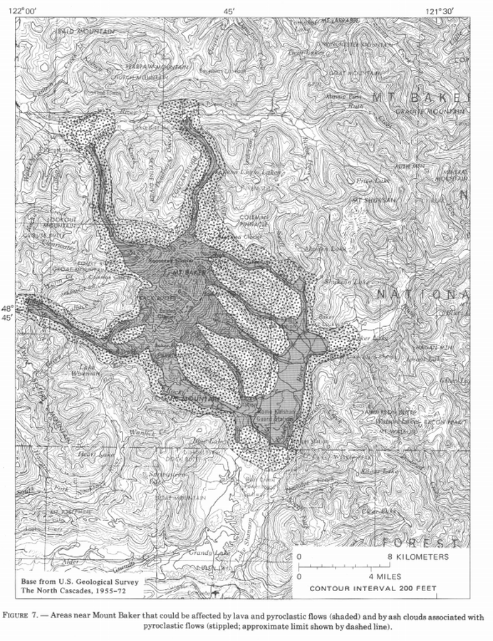
Official, Figure in hazard assessment
Areas near Mount Baker that could be affected by lava and pyroclastic flows (shaded) and by ash clouds associated with pyroclastic flows (stippled; approximate limit shown by dashed line)
Figure 7 in: Hyde, J. & Crandell, D.R. (1978). Postglacial volcanic deposits at Mount Baker, Washington, and potential hazards from future eruptions. U.S. Geological Survey, Professional Paper 1022-C, C1-C17, 1 plate in pocket. https://doi.org/10.3133/pp1022C
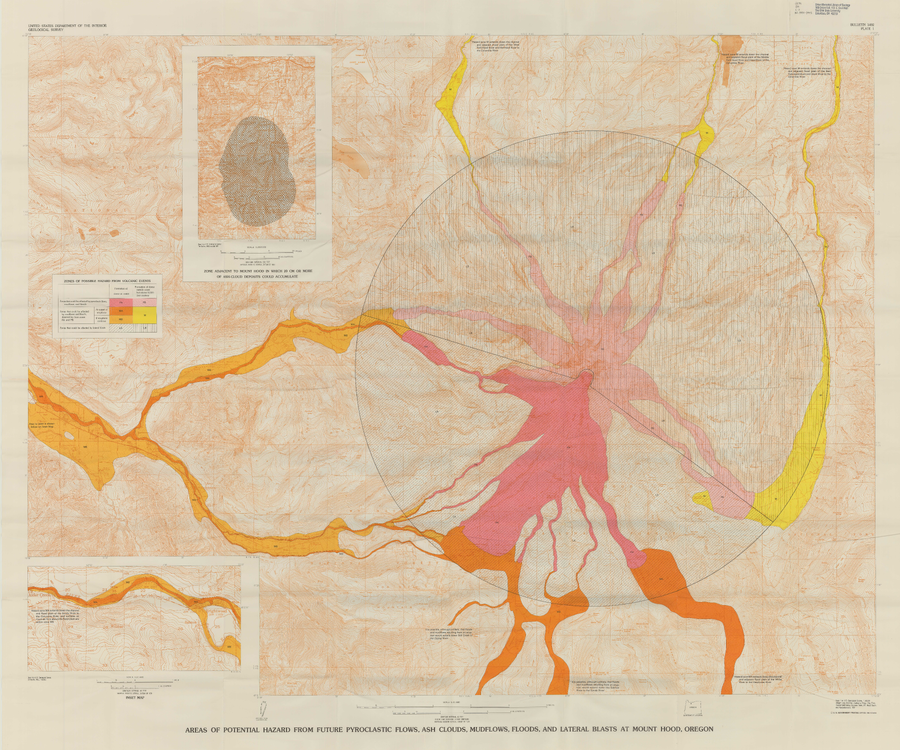
Official, Insert/poster-size map with accompanying report
Areas of Potential Hazard from Future Pyroclastic Flows, Ash Clouds, Mudflows, and Lateral Blasts at Mount Hood, Oregon
Plate 1 in: Crandell, D.R. (1980). Recent eruptive history of Mount Hood, Oregon, and potential hazards from future eruptions. U.S. Geological Survey, Bulletin 1492, 81 p. https://doi.org/10.3133/b1492
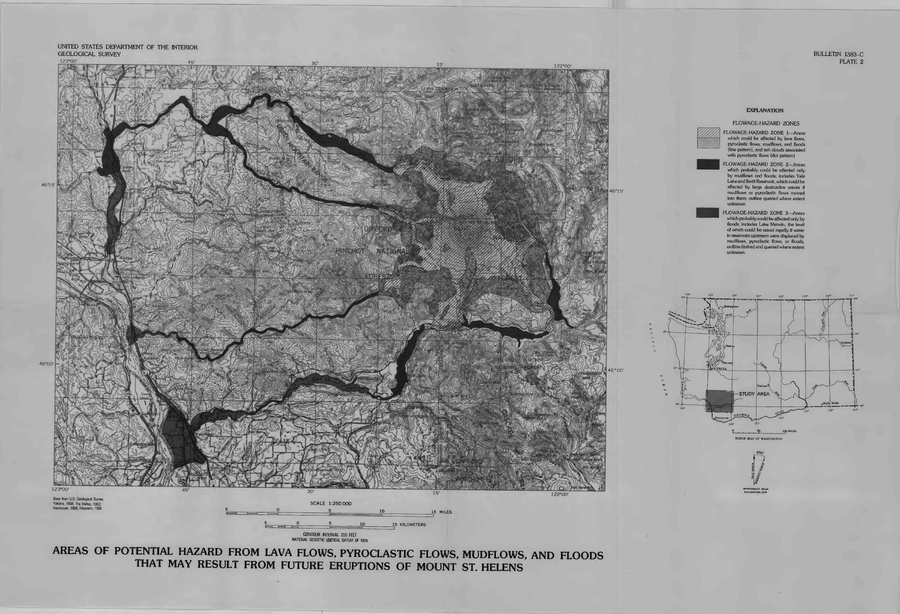
Official, Insert/poster-size map with accompanying report
Areas of Potential Hazard from Lava Flows, Pyroclastic Flows, Mudflows, and Floods that May Result from Future Eruptions of Mount St. Helens
Plate 2 in: Crandell, D.R. & Mullineaux, D.R. (1978). Potential Hazards from Future Eruptions of Mount St. Helens Volcano, Washington. U.S. Geological Survey, Bulletin 1383-C, 26 p. https://doi.org/10.3133/b1383C
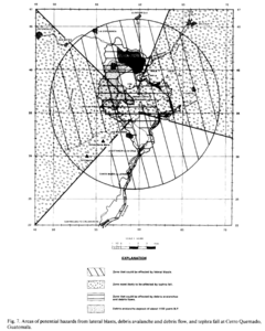
Figure in a journal article
Areas of potential hazards from lateral blasts, debris avalanche and debris flow, and tephra fall at Cerro Quemado, Guatemala.
Figure 7 in: Conway, F. M., Vallance, J. W., Rose, W. I., Johns, G. W., & Paniagua, S. (1992). Cerro Quemado, Guatemala: the volcanic history and hazards of an exogenous volcanic dome complex. Journal of Volcanology and Geothermal Research, 52(4), p. 303-323. https://doi.org/10.1016/0377-0273(92)90051-E
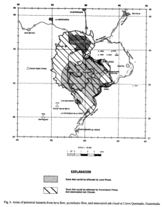
Figure in a journal article
Areas of potential hazards from lava flow, pyroclastic flow, and associated ash cloud at Cerro Quemado, Guatemala.
Figure 6 in: Conway, F. M., Vallance, J. W., Rose, W. I., Johns, G. W., & Paniagua, S. (1992). Cerro Quemado, Guatemala: the volcanic history and hazards of an exogenous volcanic dome complex. Journal of Volcanology and Geothermal Research, 52(4), p. 303-323. https://doi.org/10.1016/0377-0273(92)90051-E