
Advanced Search for Maps
Showing 61-70 of 387
Official, Sign or billboard
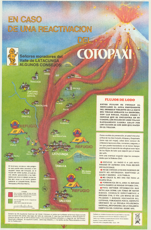
En Caso de Una Eventual Reactivacion del Volcan Cotopaxi
(In Case of a Possible Reactivation of the Cotopaxi Volcano)
Mothes, P. (1991). En Caso de Una Eventual Reactivacion del Volcan Cotopaxi. Instituto Geofísico de la Escuela Politecnica Nacional (IG-EPN) and Dirección Nacional de Defensa Civil, Quito.
Official, Flyer, brochure, short fact-sheet, or handout
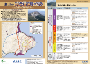
Esan Volcanic Alert Levels
Japan Meteorological Agency. (2018). Esan Volcanic Alert Levels. Volcano Monitoring and Warning Center, Volcano Division, Earthquake and Volcano Department.
Official, Map in a booklet, long fact-sheet, or handbook
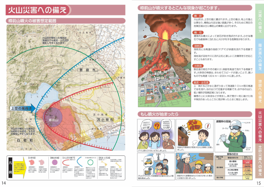
Estimated damage range of a Tarumaeyama eruption
Page 14 in: Eniwa City Hall General Affairs Department. (2021). Eniwa City Disaster Prevention Guidebook. 19 p.
Official, Hiking or trail map
Evacuation direction at the time of eruption of Mount Azuma (Oana Crater)
Azumayama Volcanic Disaster Management Council. (2019). Evacuation direction at the time of eruption of Munt Azuma (Oana Crater).
Soufrière St. Vincent, Saint Vincent and the Grenadines
Official, Figure on website
Fancy Community Multi-Hazard Map
The University of the West Indies Seismic Research Centre (UWI-SRC) and National Emergency Management Organization (NEMO). (2021). Fancy Community Multi-Hazard Map. https://uwiseismic.com/wp-content/uploads/2021/10/Fancy-Hazard-Map-scaled.jpg

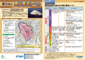
Official, Map sheet or poster
Fuji City Volcano Disaster Prevention Map
Figure 6.3.13 in: Mt. Fuji Hazard Map Review Committee. (2004). Mt. Fuji Hazard Map Review Committee Report. June 2004. https://www.bousai.go.jp/kazan/fuji_map/pdf/report_200406.pdf
Official, Flyer, brochure, short fact-sheet, or handout
Fujisan Volcanic Alert Levels
Japan Meteorological Agency. (2016). Fujisan Volcanic Alert Levels. Volcano Monitoring and Warning Center, Volcano Division, Earthquake and Volcano Department.
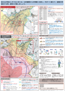
Official, Map sheet or poster
Fujiyoshida City Volcano Disaster Prevention Map
Figure 6.3.11 in: Mt. Fuji Hazard Map Review Committee. (2004). Mt. Fuji Hazard Map Review Committee Report. June 2004. https://www.bousai.go.jp/kazan/fuji_map/pdf/report_200406.pdf
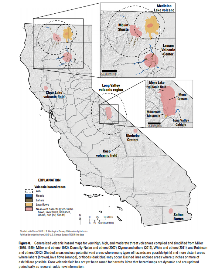
Official, Figure in hazard assessment
Generalized volcanic hazard maps for very high, high, and moderate threat volcanoes compiled and simplified from Miller (1980, 1989), Miller and others (1982), Donnelly-Nolan and others (2007), Clynne and others (2012), White and others (2011), and Robinson and others (2012)
Figure 8 in: Mangan, M., Ball, J., Wood, N., Jones, J.L., Peters, J., Abdollahian, N., Dinitz, L., Blankenheim, S., Fenton, J., & Pridmore, C. (2019). California’s exposure to volcanic hazards. U.S. Geological Survey Scientific Investigations Report 2018–5159, v. 1.1, 49 p. https://doi.org/10.3133/sir20185159
Soufrière St. Vincent, Saint Vincent and the Grenadines
Official, Figure on website
Georgetown Community Multi-Hazard Map
The University of the West Indies Seismic Research Centre (UWI-SRC) and National Emergency Management Organization (NEMO). (2021). Georgetown Community Multi-Hazard Map. https://uwiseismic.com/wp-content/uploads/2021/10/Georgetown-Hazard-Map-scaled.jpg