
Advanced Search for Maps
Showing 21-30 of 391
Official, Flyer, brochure, short fact-sheet, or handout
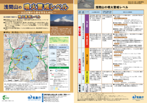
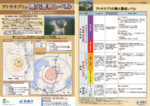
Asamayama Volcanic Alert Levels
Japan Meteorological Agency. (2016). Asamayama Volcanic Alert Levels. Volcano Monitoring and Warning Center, Volcano Division, Earthquake and Volcano Department.
Official, Map in an information statement
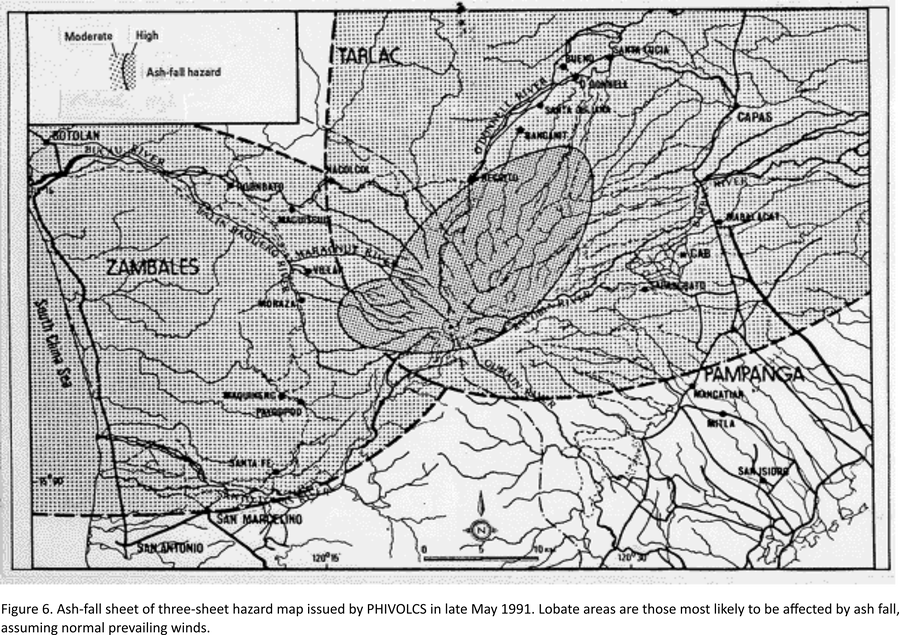
Ash-fall sheet of three-sheet hazard map issued by PHIVOLCS in late May 1991
Figure 6 in: Punongbayan, R.S., Newhall, C.G., Bautista, L.P., Garcia, D., Harlow, D.H., Hoblitt, R.P., Sabit, J.P., & Solidum, R.U. (1996). Eruption hazard assessments and warnings. In: Newhall, C.G. & Punongbayan, R.S. (Eds.) Fire and Mud: Eruptions and Lahars of Mount Pinatubo, Philippines. Philippine Institute of Volcanology and Seismology, Quezon City; University of Washington Press, Seattle.
Official, Map sheet or poster
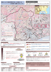
Ashigarakami District Volcanic Disaster Prevention Map
Figure 6.3.14 in: Mt. Fuji Hazard Map Review Committee. (2004). Mt. Fuji Hazard Map Review Committee Report. June 2004. https://www.bousai.go.jp/kazan/fuji_map/pdf/report_200406.pdf
Official, Flyer, brochure, short fact-sheet, or handout
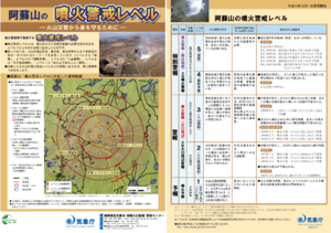
Asosan Volcanic Alert Levels
Japan Meteorological Agency. (2019). Asosan Volcanic Alert Levels. Volcano Monitoring and Warning Center, Volcano Division, Earthquake and Volcano Department.
Official, Map in an information statement
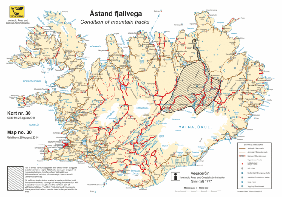
Ástand fjallvega
(Condition of mountain tracks)
Icelandic Road and Coastal Administration. (2014). Condition of mountain tracks. Map no. 30, valid from 25 August 2014.
Official, Map in an information statement
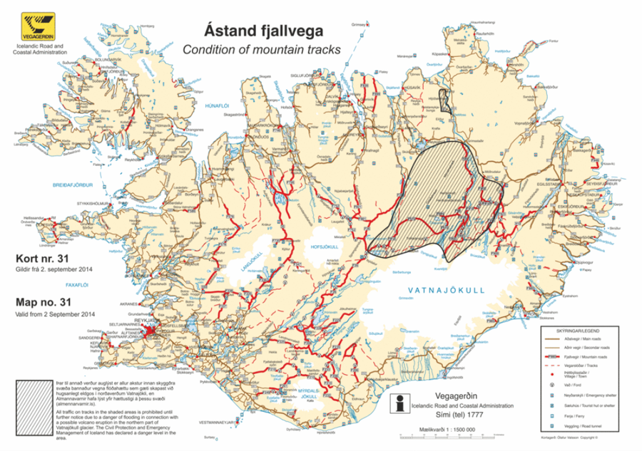
Ástand fjallvega
(Condition of mountain tracks)
Icelandic Road and Coastal Administration. (2014). Condition of mountain tracks. Map no. 31, valid from 2 September 2014.
Official, Map in a booklet, long fact-sheet, or handbook
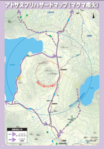
Atosanupuri Hazard map (magma eruption)
Page 7 in: Teshikaga Town Office. (2018). Teshikaga Town Disaster Prevention Guidebook.
Official, Map in a booklet, long fact-sheet, or handbook
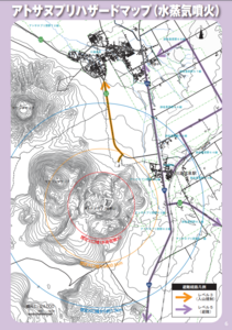
Atosanupuri Hazard Map (steam eruption)
Page 6 in: Teshikaga Town Office. (2018). Teshikaga Town Disaster Prevention Guidebook.
Official, Flyer, brochure, short fact-sheet, or handout
Atosanupuri Volcanic Alert Levels
Japan Meteorological Agency. (2018). Atosanupuri Volcanic Alert Levels. Volcano Monitoring and Warning Center, Volcano Division, Earthquake and Volcano Department.
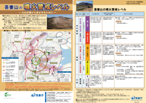
Official, Flyer, brochure, short fact-sheet, or handout
Azumayama Volcanic Alert Levels
Japan Meteorological Agency. (2019). Azumayama Volcanic Alert Levels. Volcano Monitoring and Warning Center, Volcano Division, Earthquake and Volcano Department.