
Advanced Search for Maps
Showing 11-20 of 391
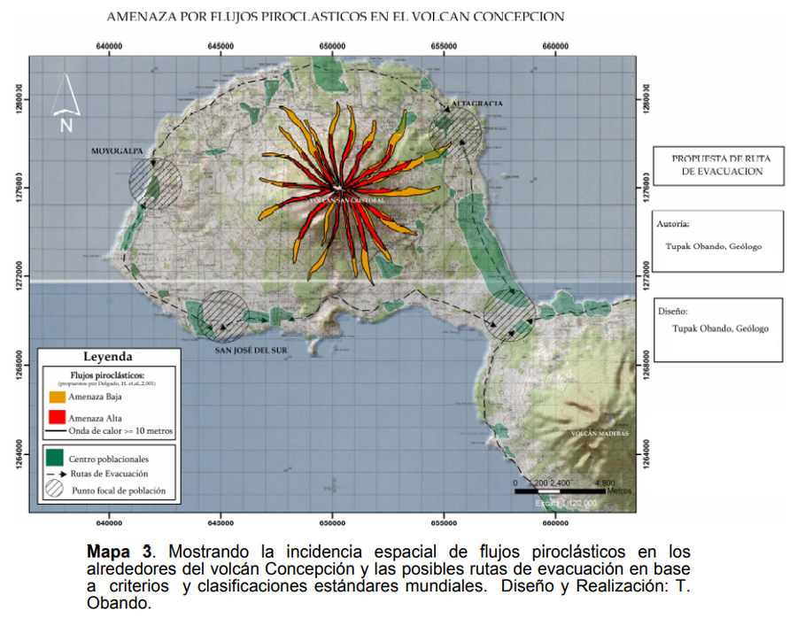
Figure in hazard assessment
Amenaza por Flujos Piroclasticos en el Volcán Concepción
(Threat due to Pyroclastic Flows in the Concepción Volcano)
Obando, T. & Navarro, M. (2009). Propuestade Rutas de Evacuación ante peligros por Caída de Cenizas y Flujos Piroclásticos en la Isla de Ometepe (Rivas, Nicaragua). https://1library.co/document/y621ejgz-propuesta-evacuacion-peligros-caida-cenizas-piroclasticos-ometepe-nicaragua.html
Official, Flyer, brochure, short fact-sheet, or handout
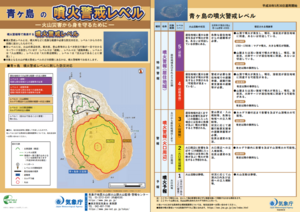
Aogashima Volcanic Alert Levels
Japan Meteorological Agency. (2018). Aogashima Volcanic Alert Levels. Volcano Monitoring and Warning Center, Volcano Division, Earthquake and Volcano Department.
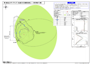
Official, Map sheet or poster
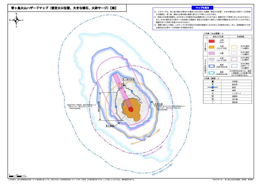
Aogashima volcanic hazard map (assumed crater position, volcanic blocks, pyroclastic surge)
Aogashima Volcano Disaster Prevention Council. (2017). Aogashima volcanic hazard map. Disaster Prevention Division, Bureau of General Affairs, Tokyo Metropolitan Government.
Official, Map sheet or poster
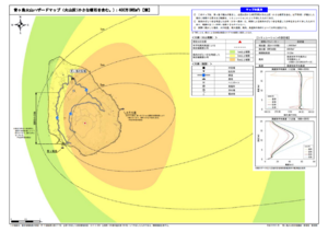
Aogashima volcano hazard map (volcanic ash (including volcanic lapilli): 4 million m³ DRE)
Aogashima Volcano Disaster Prevention Council. (2017). Aogashima volcanic hazard map. Disaster Prevention Division, Bureau of General Affairs, Tokyo Metropolitan Government.
Official, Map sheet or poster
Aogashima volcano hazard map (volcanic ash (including volcanic lapilli): 400,000 m³ DRE)
Aogashima Volcano Disaster Prevention Council. (2017). Aogashima volcanic hazard map. Disaster Prevention Division, Bureau of General Affairs, Tokyo Metropolitan Government.

Official, Sign or billboard
Area closed. Do not enter. Increased risk of eruption.
Department of Conservation. (2020). Area closed. Do not enter. Increased risk of eruption. December 2020 R183230.
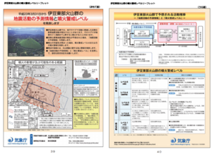
Official, Figure in hazard assessment
Area where the crater may appear and area where eruptions may affect
Page 18 in: Shizuoka Prefecture and Volcano Disaster Prevention Measure Deliberation Committee at Izu-Tobu Volcanoes. (2011). Volcano disaster prevention measure deliberation committee report at Izu-Tobu Volcanoes. Emergency Management Information Division, Shizuoka Prefecture.
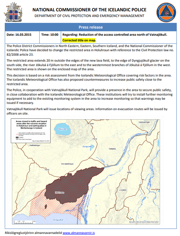
Official, Map in an information statement
Areas closed to traffic and hazard areas after the volcanic eruption in Holuhraun and earthquakes in Bárðarbunga in Iceland
National Commisioner of the Icelandic Police. (2015). Press Release 16.03.2015 10:00 Regarding: Reduction of the access controlled area north of Vatnajökull.
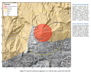
Official, Figure in hazard assessment
Áreas de restricción sugeridas a 2 y 5 km de radio a partir del cráter SW
(Suggested restriction areas 2 and 5 km radius from SW crater)
Figure 97 in: Soto, G.J. (2012). Preparación de mapas de peligros volcánicos y restricción de uso de la tierra en el volcán Turrialba. FUNDEVI, Universidad de Costa Rica, Escuela Centroamericana de Geología. 186 p.
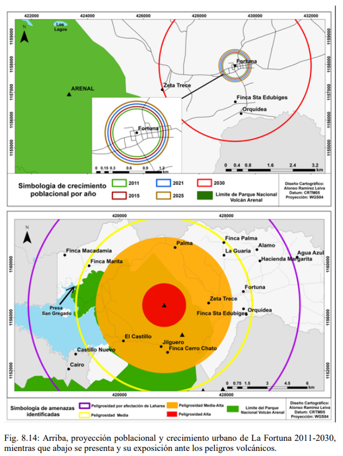
Official, Figure in hazard assessment
Arriba, proyección poblacional y crecimiento urbano de La Fortuna 2011-2030, mientras que abajo se presenta y su exposición ante los peligros volcánicos
(Above, population projection and urban growth of La Fortuna 2011-2030, while below it is presented and its exposure to volcanic dangers)
Figure 8.14 in: Alvarado, G.E., Brenes-André, F., Núñez, D., Borbón, J., Ramírez, M.A., Alpízar, Y., Núñez, S., Sibaja, J.P., Esquivel, L. (2023). Actualización del Análisis del Peligro Volcánico del Arenal, Costa Rica. Instituto Costarricense de Electricidad (ICE). Mayo 2023.