
Advanced Search for Maps
Showing 51-60 of 391
Holuhraun (Askja) & Bárdarbunga, Iceland
Official, Map in an information statement
Dæmi um verulegt sprengigos í Dyngjujökli, jafnþykktarlínur gjóskufalls
(Example of a major explosive eruption in Dyngjujökli, equal thickness lines of tephra)
Kort Jarðvísindastofnun HÍ. (2014). Dæmi um verulegt sprengigos í Dyngjujökli, jafnþykktarlínur gjóskufalls.
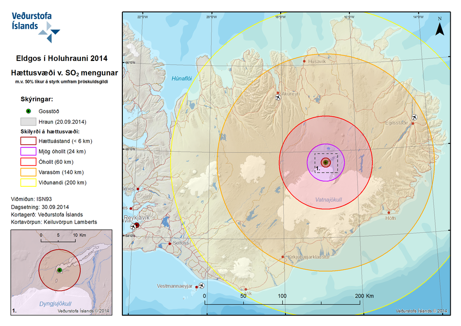
Official, Figure on website
Eldgos í Holuhrauni 2014 Hættusvæði v. SO2 Mengunar m.v. 50% líkur á styrk umfram þröskuldsgildi
(Volcanic Eruption at Holuhraun 2014 Hazardous Area SO2 pollution 50% likelihood of concentration exceeding a threshold value)
Iceland Meteorological Office (IMO). (2014). Eldgos í Holuhrauni 2014 Hættusvæði v. SO2 Mengunar [Volcanic Eruption at Holuhraun 2014 Hazardous Area SO2 pollution]. (Reprinted in: Barsotti, S. (2015). Hazard Zoning: Probabilistic hazard maps of SO2 ground concentration for Holuhraun eruption. https://en.vedur.is/pollution-and-radiation/volcanic-gas/hazard-zoning/)
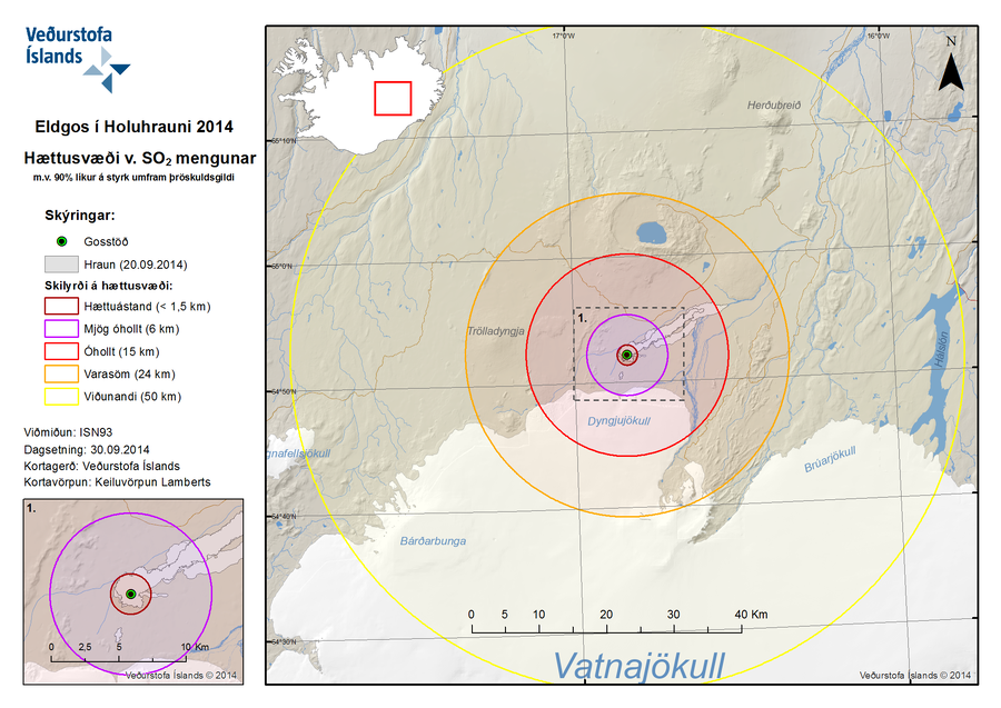
Official, Figure on website
Eldgos í Holuhrauni 2014 Hættusvæði v. SO2 Mengunar m.v. 90% líkur á styrk umfram þröskuldsgildi
(Volcanic Eruption at Holuhraun 2014 Hazardous Area SO2 pollution 90% likelihood of concentration exceeding a threshold value)
Iceland Meteorological Office (IMO). (2014). Eldgos í Holuhrauni 2014 Hættusvæði v. SO2 Mengunar [Volcanic Eruption at Holuhraun 2014 Hazardous Area SO2 pollution]. (Reprinted in: Barsotti, S. (2015). Hazard Zoning: Probabilistic hazard maps of SO2 ground concentration for Holuhraun eruption. https://en.vedur.is/pollution-and-radiation/volcanic-gas/hazard-zoning/)
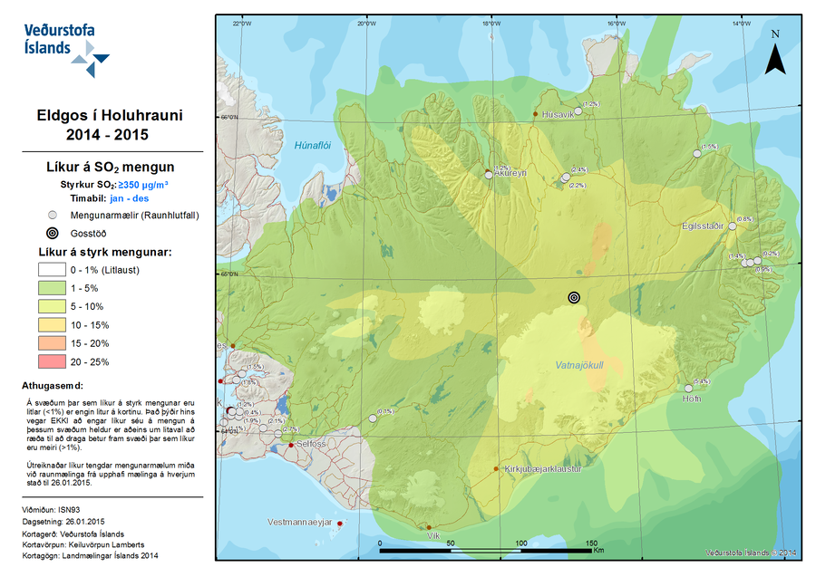
Official, Figure on website
Eldgos í Holuhrauni 2014-2015 Líkur á SO2 Mengun
(Volcanic Eruption at Holuhraun 2014-2015 Probability of SO2 Contamination)
Iceland Meteorological Office (IMO). (2015). Eldgos í Holuhrauni 2014-2015 Líkur á SO2 Mengun [Volcanic Eruption at Holuhraun 2014-2015 Probability of SO2 Contamination]. (Reprinted in: Barsotti, S. (2015). Hazard Zoning: Probabilistic hazard maps of SO2 ground concentration for Holuhraun eruption. https://en.vedur.is/pollution-and-radiation/volcanic-gas/hazard-zoning/)
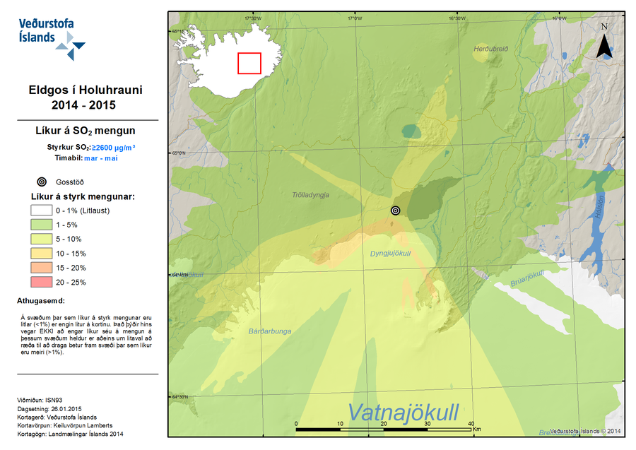
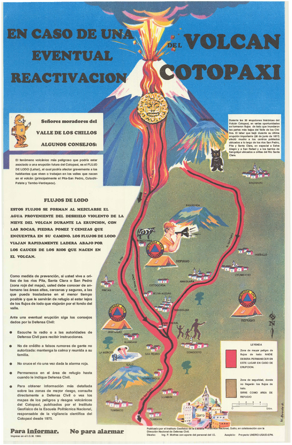
Official, Sign or billboard
En Caso de Una Eventual Reactivacion del Volcan Cotopaxi
(In Case of a Possible Reactivation of the Cotopaxi Volcano)
Mothes, P. (1990). En Caso de Una Eventual Reactivacion del Volcan Cotopaxi. Instituto Geofísico de la Escuela Politecnica Nacional and Dirección Nacional (IG-EPN) de Defensa Civil, Quito.
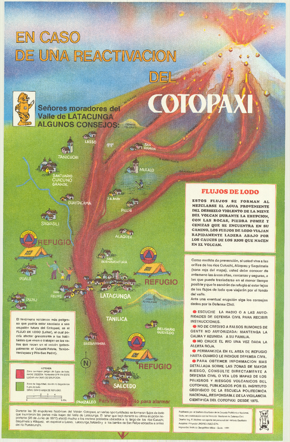
Official, Sign or billboard
En Caso de Una Eventual Reactivacion del Volcan Cotopaxi
(In Case of a Possible Reactivation of the Cotopaxi Volcano)
Mothes, P. (1991). En Caso de Una Eventual Reactivacion del Volcan Cotopaxi. Instituto Geofísico de la Escuela Politecnica Nacional (IG-EPN) and Dirección Nacional de Defensa Civil, Quito.

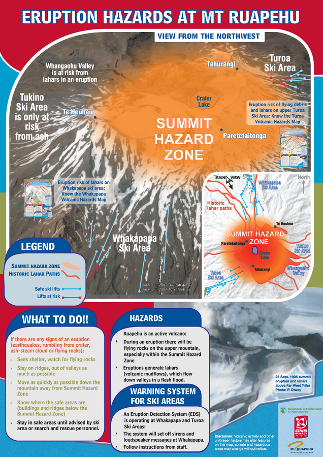
Official, Sign or billboard
Eruption Hazards at Mt. Ruapehu
GNS Science (compiler). (2007). Eruption Hazards at Mt. Ruapehu. 8 October 2007.
Official, Sign or billboard
Eruption Hazards at Mt. Ruapehu
GNS Science (compiler). (2008). Eruption Hazards at Mt. Ruapehu.
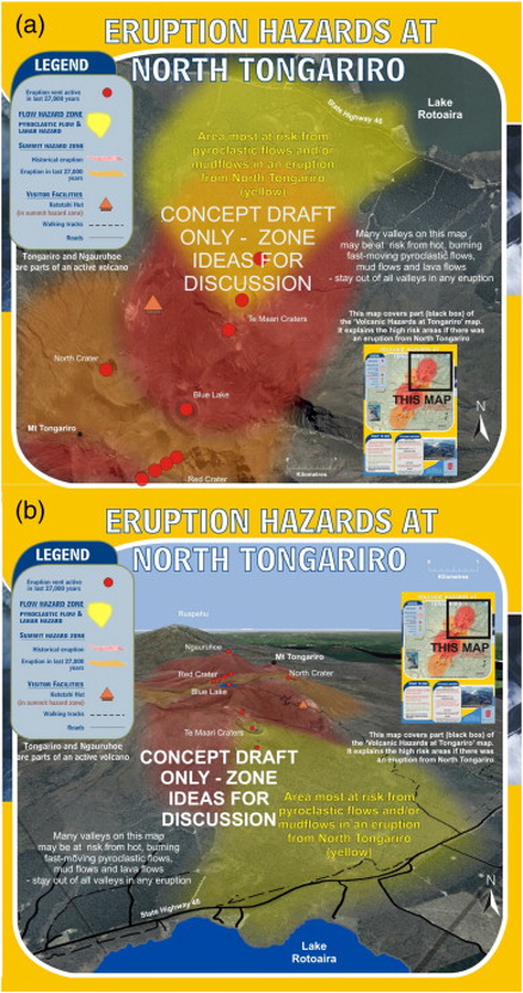
Official, Map sheet or poster
Eruption Hazards at North Tongariro
GNS Science (compiler). (2012). Te Maari Eruption Phenomena. Version 0.1, 6 August 2012. (Reprinted in: Leonard, G. S., Stewart, C., Wilson, T. M., Procter, J. N., Scott, B. J., Keys, H. J., Jolly, G.E., Wardman, J.B., Cronin. S.J. & McBride, S. K. (2014). Integrating multidisciplinary science, modelling and impact data into evolving, syn-event volcanic hazard mapping and communication: a case study from the 2012 Tongariro eruption crisis, New Zealand. Journal of Volcanology and Geothermal Research, 286, p. 208-232. https://doi.org/10.1016/j.jvolgeores.2014.08.018)