
Advanced Search for Maps
Showing 11-20 of 351
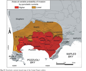
Figure in a journal article
Areas at variable probability of invasion by pyroclastic currents
Figure 15 in: Orsi, G., Di Vito, M. A., & Isaia, R. (2004). Volcanic hazard assessment at the restless Campi Flegrei caldera. Bulletin of Volcanology, 66(6), p. 514-530. https://doi.org/10.1007/s00445-003-0336-4
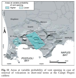
Figure in a journal article
Areas at variable probability of vent opening
Figure 11 in: Orsi, G., Di Vito, M. A., & Isaia, R. (2004). Volcanic hazard assessment at the restless Campi Flegrei caldera. Bulletin of Volcanology, 66(6), p. 514-530. https://doi.org/10.1007/s00445-003-0336-4
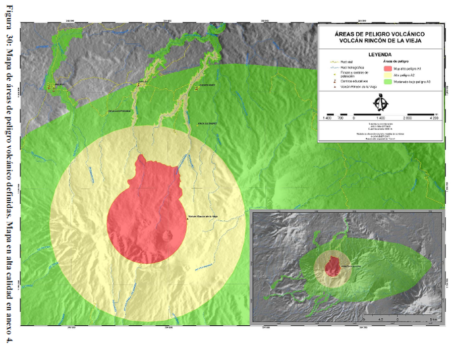
Figure in a thesis or dissertation
Áreas de Peligro Volcánico Volcán Rincón de la Vieja
(Volcanic Hazard Areas Rincón de la Vieja Volcano)
Figure 30 in: Alpízar, Y. (2018). Mapa Preliminar de Peligros Volcánicos para el Volcán Rincón de la Vieja (Costa Rica): Descripción de un Escenario de Afectación por Lahares. Ciudad Universitaria Rodrigo Facio, Costa Rica. 160 p.
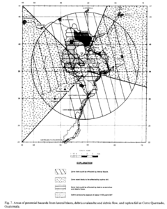
Figure in a journal article
Areas of potential hazards from lateral blasts, debris avalanche and debris flow, and tephra fall at Cerro Quemado, Guatemala.
Figure 7 in: Conway, F. M., Vallance, J. W., Rose, W. I., Johns, G. W., & Paniagua, S. (1992). Cerro Quemado, Guatemala: the volcanic history and hazards of an exogenous volcanic dome complex. Journal of Volcanology and Geothermal Research, 52(4), p. 303-323. https://doi.org/10.1016/0377-0273(92)90051-E
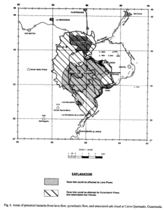
Figure in a journal article
Areas of potential hazards from lava flow, pyroclastic flow, and associated ash cloud at Cerro Quemado, Guatemala.
Figure 6 in: Conway, F. M., Vallance, J. W., Rose, W. I., Johns, G. W., & Paniagua, S. (1992). Cerro Quemado, Guatemala: the volcanic history and hazards of an exogenous volcanic dome complex. Journal of Volcanology and Geothermal Research, 52(4), p. 303-323. https://doi.org/10.1016/0377-0273(92)90051-E
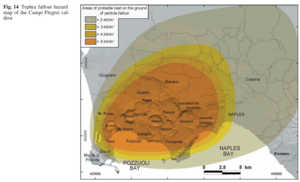
Figure in a journal article
Areas of probable load on the ground of particle fallout
Figure 14 in: Orsi, G., Di Vito, M. A., & Isaia, R. (2004). Volcanic hazard assessment at the restless Campi Flegrei caldera. Bulletin of Volcanology, 66(6), p. 514-530. https://doi.org/10.1007/s00445-003-0336-4
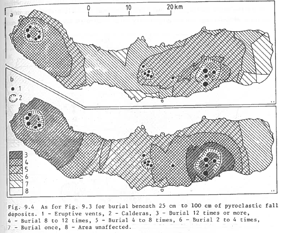
Figure in a journal article
As for Fig. 9.3 for burial beneath 25 to 100 cm of pyroclastic fall deposits
Figure 9.4 in: Booth, B., Croasdale, R., & Walker, G.L. (1983). Volcanic hazard on Sao Miguel, Azores. In: Tazieff, H. & Sabroux, J.C. (eds.). Forecasting Volcanic Events. Elsevier, Amsterdam. p. 99-109.
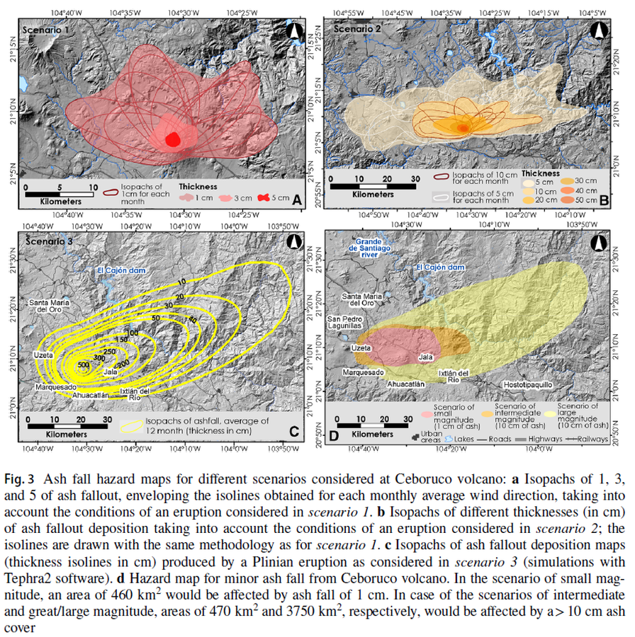
Figure in a journal article
Ash fall hazard maps for different scenarios considered at Ceboruco volcano
Figure 3 in: Sieron, K., Ferrés, D., Siebe, C., Constantinescu, R., Capra, L., Connor, C., Connor, L., Groppelli, G. & Zuccolotto, K.G. (2019). Ceboruco hazard map: part II—modeling volcanic phenomena and construction of the general hazard map. Natural Hazards, 96(2), p. 893-933. https://doi.org/10.1007/s11069-019-03577-5
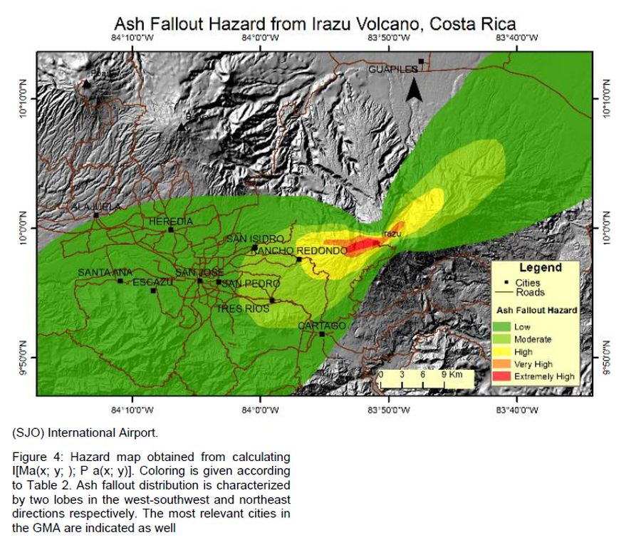
Figure in a journal article
Ash Fallout Hazard from Irazu Volcano, Costa Rica
Figure 4 in: Barrantes, G., Núñez, S., & Malavassi, E. (2018). Ash fallout hazard from Irazú volcano, Costa Rica. Revista Geográfica de Chile Terra Australis, 54(1), 13-25. https://doi.org/10.23854/07199562.2018541Barrantes13

Figure in a journal article
Ash fallout simulations (thickness) with a 5-km column height and volume of 0.3 km³
Figure 10 in: Bartolini, S., Geyer, A., Martí, J., Pedrazzi, D., & Aguirre-Díaz, G. (2014). Volcanic hazard on Deception Island (South Shetland Islands, Antarctica). Journal of Volcanology and Geothermal Research, 285, p. 150-168. https://doi.org/10.1016/j.jvolgeores.2014.08.009