
Advanced Search for Maps
Showing 31-40 of 351
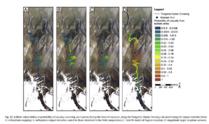
Figure in a journal article
Ballistic vulnerability or probability of casualty assuming an eruption during the time of exposure, along the Tongariro Alpine Crossing
Figure 12 in: Fitzgerald, R. H., Tsunematsu, K., Kennedy, B. M., Breard, E. C. P., Lube, G., Wilson, T. M., Jolly, A.D., Pawson, J., Rosenburg, M.D., & Cronin, S. J. (2014). The application of a calibrated 3D ballistic trajectory model to ballistic hazard assessments at Upper Te Maari, Tongariro. Journal of volcanology and geothermal research, 286, p. 248-262. https://doi.org/10.1016/j.jvolgeores.2014.04.006
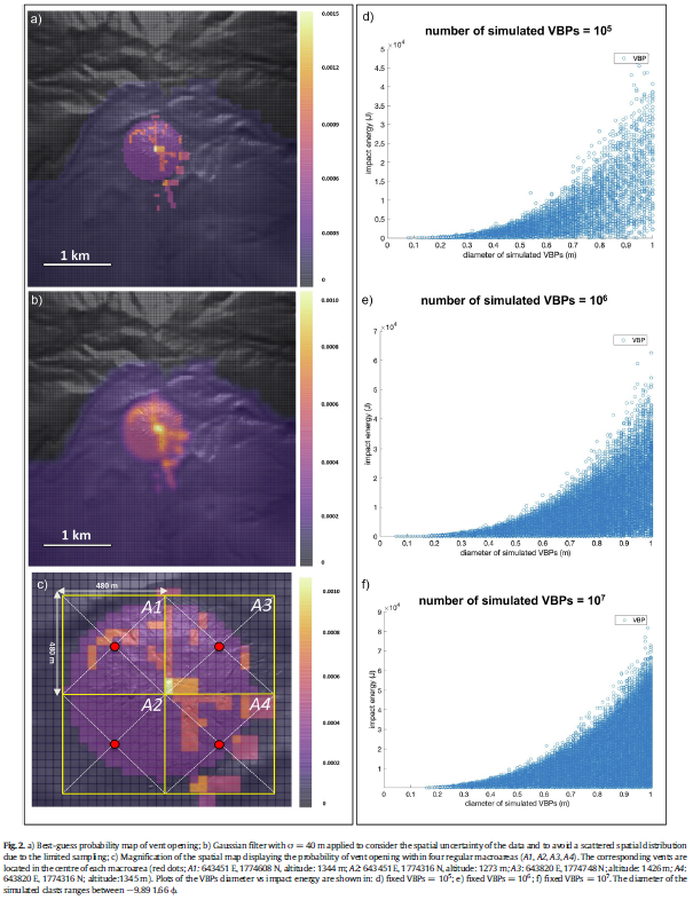
Figure in a journal article
Best-guess probability map of vent opening
Figure 2 in: Massaro, S., Rossi, E., Sandri, L., Bonadonna, C., Selva, J., Moretti, R., & Komorowski, J. C. (2022). Assessing hazard and potential impact associated with volcanic ballistic projectiles: The example of La Soufrière de Guadeloupe volcano (Lesser Antilles). Journal of volcanology and geothermal research, 423, 107453. https://doi.org/10.1016/j.jvolgeores.2021.107453
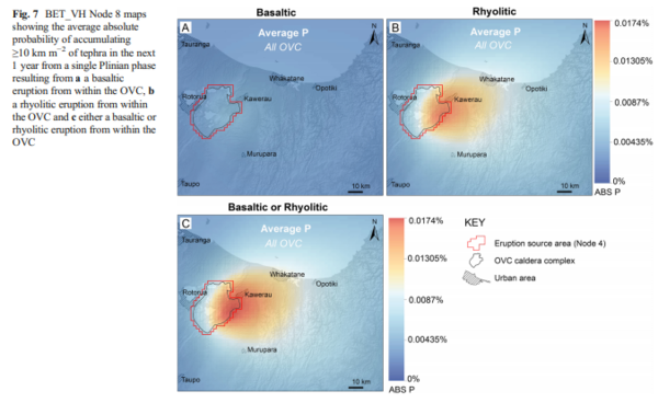
Figure in a journal article
BET_VH Node 8 maps showing the average absolute probability of accumulating ≥10 km m−2 of tephra in the next 1 year from a single Plinian phase resulting from a a basaltic eruption from within the OVC, b a rhyolitic eruption from within the OVC and c either a basaltic or rhyolitic eruption from within the OVC
Figure 7 in: Thompson, M. A., Lindsay, J. M., Sandri, L., Biass, S., Bonadonna, C., Jolly, G., & Marzocchi, W. (2015). Exploring the influence of vent location and eruption style on tephra fall hazard from the Okataina Volcanic Centre, New Zealand. Bulletin of volcanology, 77(5), 38. https://doi.org/10.1007/s00445-015-0926-y
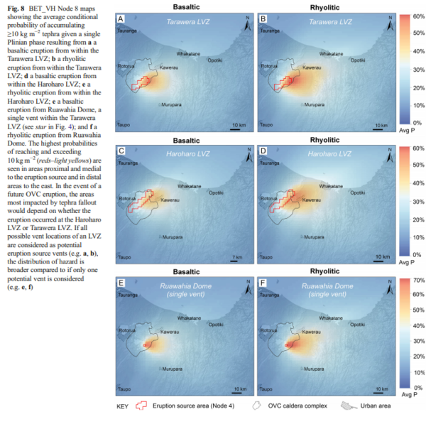
Figure in a journal article
BET_VH Node 8 maps showing the average conditional probability of accumulating ≥10 kg m−2 tephra given a single Plinian phase resulting from a a basaltic eruption from within the Tarawera LVZ; b a rhyolitic eruption from within the Tarawera LVZ; d a basaltic eruption from within the Haroharo LVZ; e a rhyolitic eruption from within the Haroharo LVZ; e a basaltic eruption from Ruawahia Dome, a single vent within the Tarawera LVZ (see star in Fig. 4); and f a rhyolitic eruption from Ruawahia Dome
Figure 8 in: Thompson, M. A., Lindsay, J. M., Sandri, L., Biass, S., Bonadonna, C., Jolly, G., & Marzocchi, W. (2015). Exploring the influence of vent location and eruption style on tephra fall hazard from the Okataina Volcanic Centre, New Zealand. Bulletin of volcanology, 77(5), 38. https://doi.org/10.1007/s00445-015-0926-y
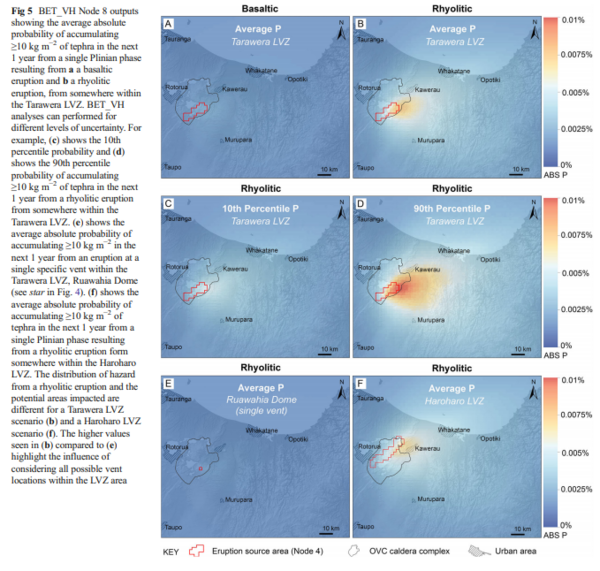
Figure in a journal article
BET_VH Node 8 outputs showing the average absolute probability of accumulating ≥10 kg m−2 of tephra in the next 1 year from a single Plinian phase resulting from a a basaltic eruption and b a rhyolitic eruption, from somewhere within the Tarawera LVZ
Figure 5 in: Thompson, M. A., Lindsay, J. M., Sandri, L., Biass, S., Bonadonna, C., Jolly, G., & Marzocchi, W. (2015). Exploring the influence of vent location and eruption style on tephra fall hazard from the Okataina Volcanic Centre, New Zealand. Bulletin of volcanology, 77(5), 38. https://doi.org/10.1007/s00445-015-0926-y

Figure in a journal article
Carte de Risque Volcanique
(Volcanic Hazard Map)
Figure 1 in: Tedesco, D. (2003). 1995 Nyiragongo and Nyamulagira activity in the Virunga National Park: A volcanic crisis. Acta vulcanologica, 14(1-2), 149-155.
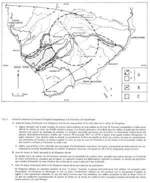
Figure in a journal article
Carte de zonation des risques d'éruption magmatique à la Soufrière de Guadeloupe
(Zonation map of magmatic eruption risks at Soufrière in Guadeloupe)
Figure 5 in: Westercamp, D. (1981). Cartographie du risque volcanique a la soufriere de guadeloupe: Retrospective et tendance actuelle. Bulletin of the International Association of Engineering Geology-Bulletin de l'Association Internationale de Géologie de l'Ingénieur, 23(1), p. 25-32. https://doi.org/10.1007/BF02594723
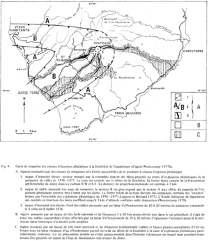
Figure in a journal article
Carte de zonation des risques d'éruption phréatique à la Soufrière de Guadeloupe (d'après Westercamp 1977b)
(Zonation map of phreatic eruption risks at Soufrière in Guadeloupe (from Westercamp 1977b))
Figure 4 in: Westercamp, D. (1981). Cartographie du risque volcanique a la soufriere de guadeloupe: Retrospective et tendance actuelle. Bulletin of the International Association of Engineering Geology-Bulletin de l'Association Internationale de Géologie de l'Ingénieur, 23(1), p. 25-32. https://doi.org/10.1007/BF02594723
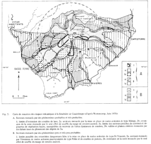
Figure in a journal article
Carte de zonation des risques volcaniques á la Soufrière de Guadeloupe (d'ápres Westercamp, Juin 1976)
(Zonation map of volcanic risks at Soufrière in Guadeloupe (after Westercamp, June 1976))
Figure 2 in: Westercamp, D. (1981). Cartographie du risque volcanique a la soufriere de guadeloupe: Retrospective et tendance actuelle. Bulletin of the International Association of Engineering Geology-Bulletin de l'Association Internationale de Géologie de l'Ingénieur, 23(1), p. 25-32. https://doi.org/10.1007/BF02594723
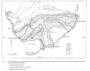
Figure in a journal article
Carte montrant les zones susceptibles d'être menacées par une éventuelle éruption de type péléen du volcan de la Soufrière de Guadeloupe (d'ápres Barrabe 1960)
(Map showing the areas likely to be threatened by a possible Pelean-type eruption of the Soufrière volcano in Guadeloupe (from Barrabe 1960).)
Figure 1 in: Westercamp, D. (1981). Cartographie du risque volcanique a la soufriere de guadeloupe: Retrospective et tendance actuelle. Bulletin of the International Association of Engineering Geology-Bulletin de l'Association Internationale de Géologie de l'Ingénieur, 23(1), p. 25-32. https://doi.org/10.1007/BF02594723