
Advanced Search for Maps
Showing 61-70 of 167
Soufrière St. Vincent, Saint Vincent and the Grenadines
Official, Figure on website
Fancy Community Multi-Hazard Map
The University of the West Indies Seismic Research Centre (UWI-SRC) and National Emergency Management Organization (NEMO). (2021). Fancy Community Multi-Hazard Map. https://uwiseismic.com/wp-content/uploads/2021/10/Fancy-Hazard-Map-scaled.jpg
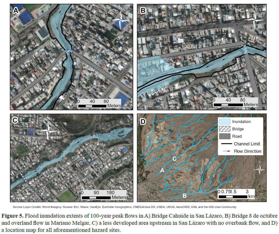
Figure in a journal article
Flood inundation extents of 100-year peak flows
Figure 5 in: Mazer, K. E., Tomasek, A. A., Daneshvar, F., Bowling, L. C., Frankenberger, J. R., McMillan, S. K., Novoa, H.M., & Zeballos‐Velarde, C. (2021). Integrated hydrologic and hydraulic analysis of torrential flood hazard in Arequipa, Peru. Journal of Contemporary Water Research & Education, 171(1), 93-110. https://doi.org/10.1111/j.1936-704X.2020.3347.x
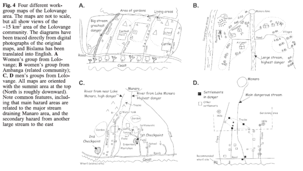
Figure in a journal article
Four different workgroup maps of the Lolovange area
Figure 4 in: Cronin, S.J., Gaylord, D.R., Charley, D., Alloway, B.V., Wallez, S., & Esau, J.W. (2004). Participatory methods of incorporating scientific with traditional knowledge for volcanic hazard management on Ambae Island, Vanuatu. Bulletin of volcanology, 66(7), p. 652-668. https://doi.org/10.1007/s00445-004-0347-9
Soufrière St. Vincent, Saint Vincent and the Grenadines
Official, Figure on website
Georgetown Community Multi-Hazard Map
The University of the West Indies Seismic Research Centre (UWI-SRC) and National Emergency Management Organization (NEMO). (2021). Georgetown Community Multi-Hazard Map. https://uwiseismic.com/wp-content/uploads/2021/10/Georgetown-Hazard-Map-scaled.jpg
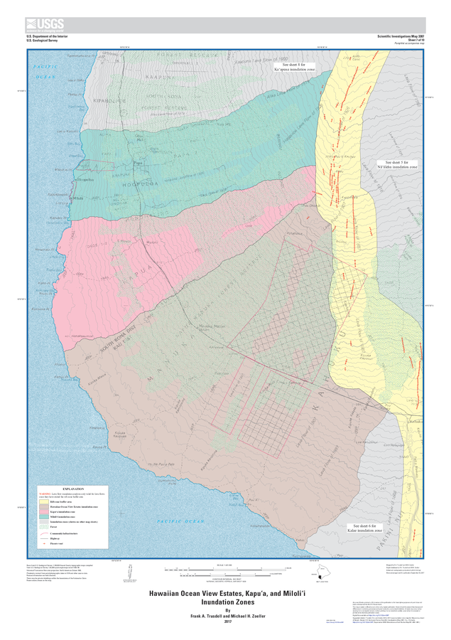
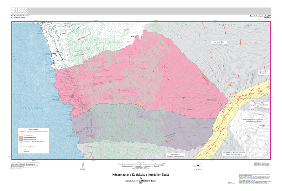
Official, Insert/poster-size map with accompanying report
Hawaiian Ocean View Estates, Kapuʻa, and Miloliʻi Inundation Zones
Sheet 7 in: Trusdell, F.A. & Zoeller, M.H. (2017). Lava inundation zone maps for Mauna Loa, Island of Hawaiʻi, Hawaii. U.S. Geological Survey, Scientific Investigations Map 3387, 12 p., 10 sheets. https://doi.org/10.3133/sim3387
Official, Map in a booklet, long fact-sheet, or handbook
Hazard map of large-scale eruption
Asamayama Volcanic Disaster Prevention Committee. (2019). Asamayama Volcanic Disaster Prevention Map. Tsumagoi Village.
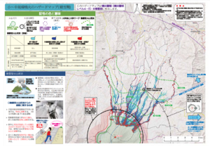
Official, Map in a booklet, long fact-sheet, or handbook
Hazard map of small to medium-scale eruptions (snow season)
Asamayama Volcanic Disaster Prevention Committee. (2019). Asamayama Volcanic Disaster Prevention Map. Tsumagoi Village.
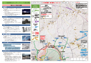
Official, Map in a booklet, long fact-sheet, or handbook
Hazard map of small to medium-scale eruptions (snowless period)
Asamayama Volcanic Disaster Prevention Committee. (2019). Asamayama Volcanic Disaster Prevention Map. Tsumagoi Village.
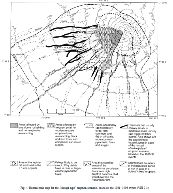
Figure in a journal article
Hazard-zone map for the 'Merapi-type' eruption scenario, based on the 1961-1996 events (VEI 2-3)
Figure 4 in: Thouret, J.-C., Lavigne, F., Kelfoun, K., & Bronto, S. (2000). Toward a revised hazard assessment at Merapi volcano, Central Java. Journal of Volcanology and Geothermal Research, 100(1-4), p. 479-502. https://doi.org/10.1016/S0377-0273(00)00152-9
Official, Insert/poster-size map with accompanying report
Hōnaunau and Kealakekua Inundation Zones
Sheet 9 in: Trusdell, F.A. & Zoeller, M.H. (2017). Lava inundation zone maps for Mauna Loa, Island of Hawaiʻi, Hawaii. U.S. Geological Survey, Scientific Investigations Map 3387, 12 p., 10 sheets. https://doi.org/10.3133/sim3387