
Advanced Search for Maps
Showing 51-60 of 167
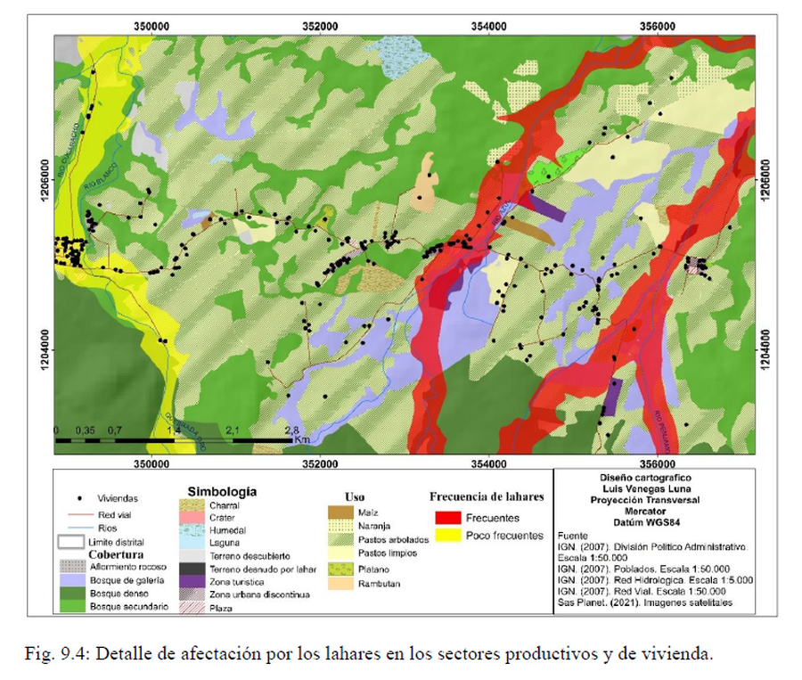
Official, Figure in hazard assessment
Detalle de afectación por los lahares en los sectores productivos y de vivienda
(Detail of the impact caused by lahars in the productive and housing sectors)
Figure 9.4 in: Alvarado, G.E., Brenes-André, J., Venegas, L., Alpízar, Y., Núñez, S., Sánchez, M., Abarca, K., Abarca, J., Báez, W.A., Sibaja, J.P., Esquivel, L., & Arcia, T. (2022). Análisis del Peligro Volcánico del Rincón de la Vieja, Costa Rica. Instituto Costarricense de Electricidad (ICE). Setiembre 2022.
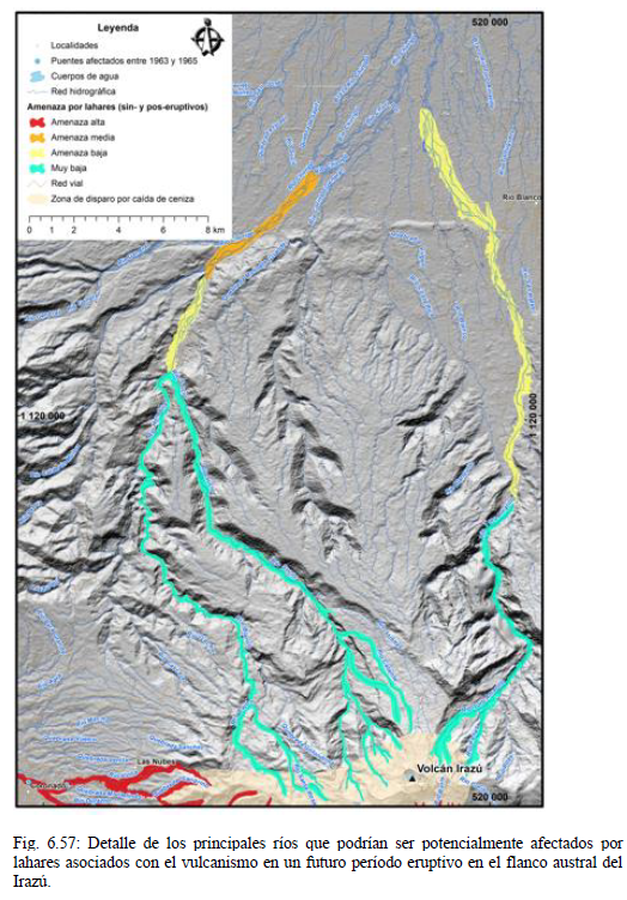
Official, Figure in hazard assessment
Detalle de los principales ríos que podrían ser potencialmente afectados por lahares asociados con el vulcanismo en un futuro período eruptivo en el flanco austral del Irazú
(Detail of the main rivers that could potentially be affected by lahars associated with volcanism in a future eruptive period on the southern flank of Irazú)
Figure 6.57 in: Alvarado, G.E., Campos-Durán, D., Brenes-André, J., Alpízar, Y., Núñez, S., Esquivel, L., Sibaja, J.P. & Fallas, B. (2021). Peligro Volcánico del Irazú, Costa Rica. Comisión Nacional de Prevención de Riesgos y Atención de Emergencias (CNE). Deciembre 2021.
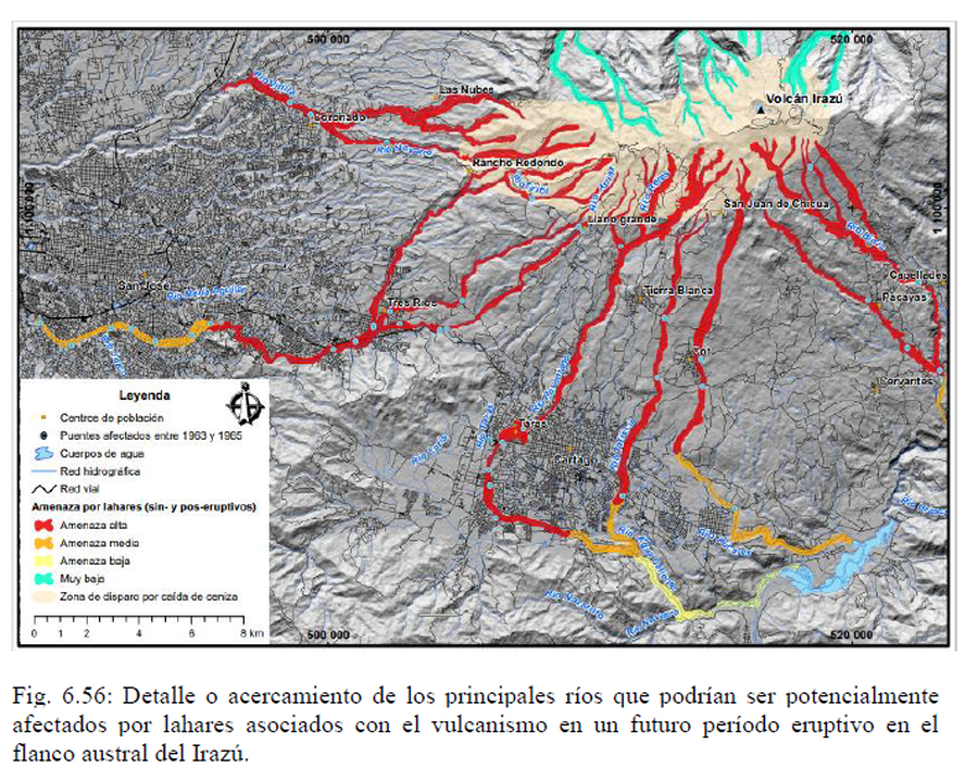
Official, Figure in hazard assessment
Detalle o acercamiento de los principales ríos que podrían ser potencialmente afectados por lahares asociados con el vulcanismo en un futuro período eruptivo en el flanco austral del Irazú
(Detail or close-up of the main rivers that could potentially be affected by lahars associated with volcanism in a future eruptive period on the southern flank of Irazú)
Figure 6.56 in: Alvarado, G.E., Campos-Durán, D., Brenes-André, J., Alpízar, Y., Núñez, S., Esquivel, L., Sibaja, J.P. & Fallas, B. (2021). Peligro Volcánico del Irazú, Costa Rica. Comisión Nacional de Prevención de Riesgos y Atención de Emergencias (CNE). Deciembre 2021.

Official, Figure in hazard assessment
Diagrammatic representation (best guess) of relative risk on Oahu from fallout of tephra originating in the zone of most recent volcanism.
Figure 2 in: Crandell, D. R. (1975). Assessment of volcanic risk on the island of Oahu, Hawaii. U.S. Geological Survey, Open-File Report 75-287. https://doi.org/10.3133/ofr75287
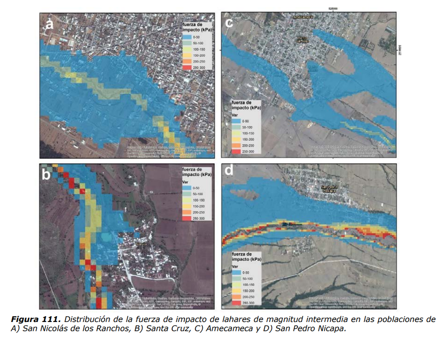
Official, Figure in hazard assessment
Distribución de la fuerza de impacto de lahares de magnitud intermedia
(Distribution of the impact force of lahars of intermediate magnitude)
Figure 111 in: Martin Del Pozzo, A.L, Alatorre Ibargüengoitia M., Arana Salinas L., Bonasia R., Capra Pedol L., Cassata W., Cordoba G., Cortés Ramos J., Delgado Granados H., Ferrés López M.D., Fonseca Álvarez R., García Reynoso J.A., Gisbert G., Guerrero López D.A., Jaimes Viera M., Macías Vázquez J.L., Nieto Obregon J., Nieto Torres A., Paredes Ruiz P.A., Portocarrero Martínez J., Renne P., Rodríguez Espinosa D.M., Salinas Sánchez S., Siebe Grabach C., & Tellez Ugalde E. (2017). Estudios geológicos y actualización del mapa de peligros del volcán Popocatépetl. Memoria técnica del mapa de peligros del volcán Popocatépetl. Instituto de Geofísica, Universidad Nacional Autónoma de México (UNAM).
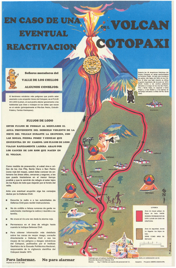
Official, Sign or billboard
En Caso de Una Eventual Reactivacion del Volcan Cotopaxi
(In Case of a Possible Reactivation of the Cotopaxi Volcano)
Mothes, P. (1990). En Caso de Una Eventual Reactivacion del Volcan Cotopaxi. Instituto Geofísico de la Escuela Politecnica Nacional and Dirección Nacional (IG-EPN) de Defensa Civil, Quito.
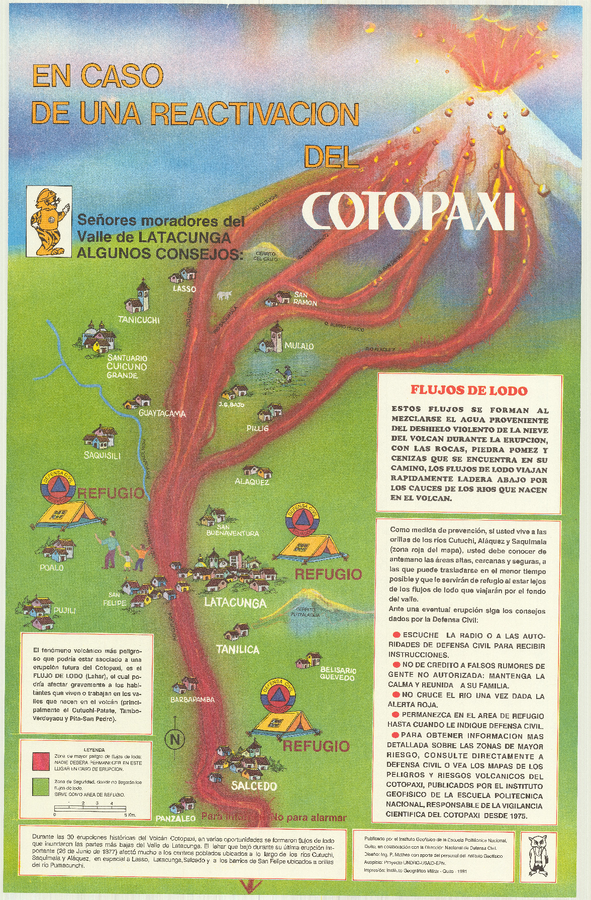
Official, Sign or billboard
En Caso de Una Eventual Reactivacion del Volcan Cotopaxi
(In Case of a Possible Reactivation of the Cotopaxi Volcano)
Mothes, P. (1991). En Caso de Una Eventual Reactivacion del Volcan Cotopaxi. Instituto Geofísico de la Escuela Politecnica Nacional (IG-EPN) and Dirección Nacional de Defensa Civil, Quito.
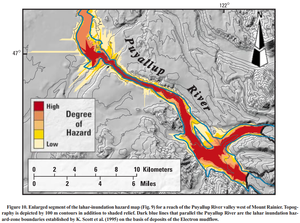
Official, Figure in a journal article
Enlarged segment of the lahar-inundation hazard map (Fig. 9) for a reach of the Puyallup River valley west of Mount Rainier
Figure 10 in: Iverson, R. M., Schilling, S. P., & Vallance, J. W. (1998). Objective delineation of lahar-inundation hazard zones. Geological Society of America Bulletin, 110(8), 972-984. https://doi.org/10.1130/0016-7606(1998)110<0972:ODOLIH>2.3.CO;2

Figure in a journal article
Estimated Travel Time of Mudflows at Mount Hood, Oregon
Preppernau, C. A., & Jenny, B. (2016). Estimated travel time of mudflows at Mount Hood, Oregon. Journal of Maps, 12(5), p. 711-715. https://doi.org/10.1080/17445647.2015.1120244
Official, Map in a booklet, long fact-sheet, or handbook
Evacuation facilities
Asamayama Volcanic Disaster Prevention Committee. (2019). Asamayama Volcanic Disaster Prevention Map. Tsumagoi Village.