
Advanced Search for Maps
Showing 61-70 of 528
Figure in a journal article
Atmospheric dispersion of tephra for a threshold of 2 mg m−3 for all FL for the eruption scenarios of Hekla ERS 1947-type (a, b, c), Katla LLERS (d, e, f) and Askja OES 1875-type (g, h, i)
Figure 13 in: Biass, S., Scaini, C., Bonadonna, C., Folch, A., Smith, K., & Höskuldsson, A. (2014). A multi-scale risk assessment for tephra fallout and airborne concentration from multiple Icelandic volcanoes–Part 1: Hazard assessment. Natural hazards and earth system sciences, 14(8), 2265-2287. https://doi.org/10.5194/nhess-14-2265-2014
Figure in a journal article
Best-guess probability map of vent opening
Figure 2 in: Massaro, S., Rossi, E., Sandri, L., Bonadonna, C., Selva, J., Moretti, R., & Komorowski, J. C. (2022). Assessing hazard and potential impact associated with volcanic ballistic projectiles: The example of La Soufrière de Guadeloupe volcano (Lesser Antilles). Journal of volcanology and geothermal research, 423, 107453. https://doi.org/10.1016/j.jvolgeores.2021.107453
Figure in a journal article
BET_VH Node 8 maps showing the average conditional probability of accumulating ≥10 kg m−2 tephra given a single Plinian phase resulting from a a basaltic eruption from within the Tarawera LVZ; b a rhyolitic eruption from within the Tarawera LVZ; d a basaltic eruption from within the Haroharo LVZ; e a rhyolitic eruption from within the Haroharo LVZ; e a basaltic eruption from Ruawahia Dome, a single vent within the Tarawera LVZ (see star in Fig. 4); and f a rhyolitic eruption from Ruawahia Dome
Figure 8 in: Thompson, M. A., Lindsay, J. M., Sandri, L., Biass, S., Bonadonna, C., Jolly, G., & Marzocchi, W. (2015). Exploring the influence of vent location and eruption style on tephra fall hazard from the Okataina Volcanic Centre, New Zealand. Bulletin of volcanology, 77(5), 38. https://doi.org/10.1007/s00445-015-0926-y
Figure in a journal article
BET_VH Node 8 outputs showing the average absolute probability of accumulating ≥10 kg m−2 of tephra in the next 1 year from a single Plinian phase resulting from a a basaltic eruption and b a rhyolitic eruption, from somewhere within the Tarawera LVZ
Figure 5 in: Thompson, M. A., Lindsay, J. M., Sandri, L., Biass, S., Bonadonna, C., Jolly, G., & Marzocchi, W. (2015). Exploring the influence of vent location and eruption style on tephra fall hazard from the Okataina Volcanic Centre, New Zealand. Bulletin of volcanology, 77(5), 38. https://doi.org/10.1007/s00445-015-0926-y
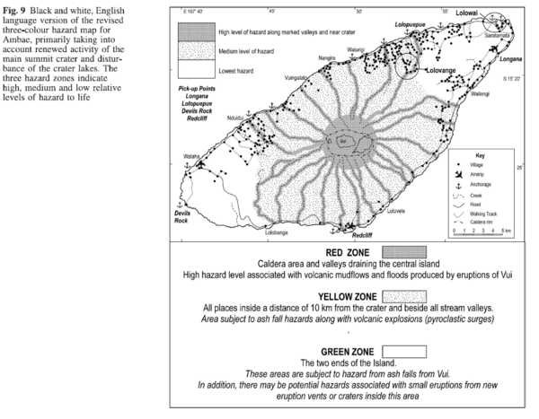
Figure in a journal article
Black and white, English language version of the revised three-colour hazard map for Ambae, primarily taking into account renewed activity of the main summit crater and disturbance of the crater lakes
Figure 9 in: Cronin, S.J., Gaylord, D.R., Charley, D., Alloway, B.V., Wallez, S., & Esau, J.W. (2004). Participatory methods of incorporating scientific with traditional knowledge for volcanic hazard management on Ambae Island, Vanuatu. Bulletin of volcanology, 66(7), p. 652-668. https://doi.org/10.1007/s00445-004-0347-9
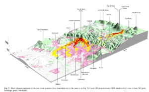
Figure in a journal article
Block diagram appraisal of the two event scenario
Figure 9 in: Latutrie, B., Andredakis, I., De Groeve, T., Harris, A. J. L., Langlois, E., de Vries, B. V. W., Saubin, E., Bilotta, G., Cappello, A., Crisci, G.M., D'ambrosio, D., Del Negro, C., Favalli, M., Fujita, E., Iovine, G., Kelfoun, K., Rongo, R., Spataro, W., Tarquini, S., Coppola, D., Ganci, G., Marchese, F., Pergola, N., & Tramutoli, V. (2016). Testing a geographical information system for damage and evacuation assessment during an effusive volcanic crisis. In: Harris, A.J.L., De Groeve, T., & Carn, S.A. (Eds.) Detecting, Modelling and Responding to Effusive Eruptions. Geological Society, London, Special Publications, 426(1), p. 649-672. https://doi.org/10.1144/SP426.19
Official, Insert/poster-size map with accompanying report
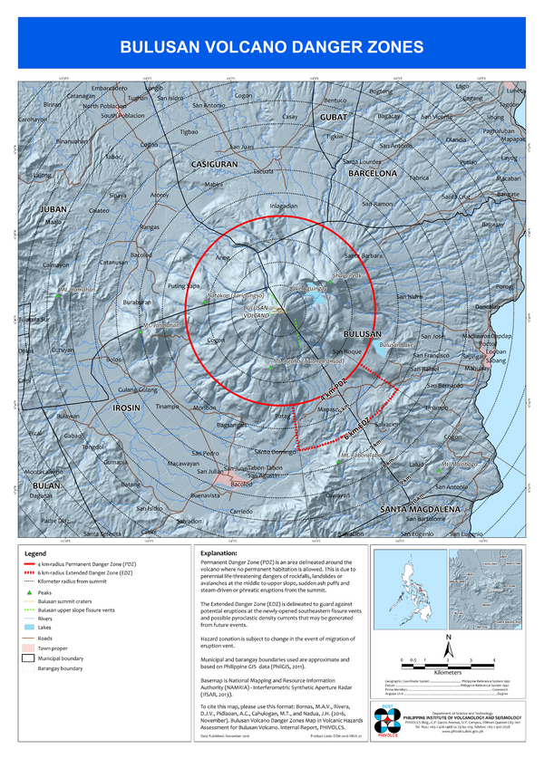
Bulusan Volcano Danger Zones
Bornas, M.A.V., Rivera, D.J.V., Pidlaoan, A.C., Cahulogan, M.T., & Nadua, J.H. (2016). Bulusan Volcano Danger Zones Map. in: Volcanic Hazard Assessment for Bulusan Volcano. Internal Report, Philippine Institute of Volcanology and Seismology (PHIVOLCS)..

Official, Insert/poster-size map with accompanying report
Bulusan Volcano Lahar Hazard Map
Rivera, D.J.V., Bornas, M.A.V., Pidlaoan, A.C., Cahulogan, M.T., & Nadua, J.H. (2016). Bulusan Volcano Lahar Hazard Map. in: Volcanic Hazard Assessment for Bulusan Volcano. Internal Report, Philippine Institute of Volcanology and Seismology (PHIVOLCS).
Official, Insert/poster-size map with accompanying report
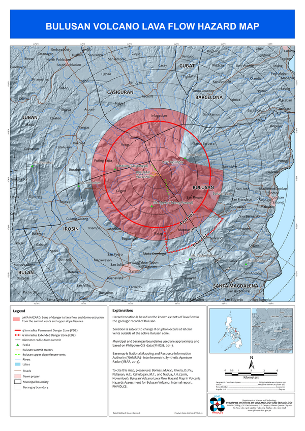
Bulusan Volcano Lava Hazard Map
Bornas, M.A.V., Rivera, D.J.V., Pidlaoan, A.C., Cahulogan, M.T., & Nadua, J.H. (2016). Bulusan Volcano Lava Flow Hazard Map. in: Volcanic Hazard Assessment for Bulusan Volcano. Internal Report, Philippine Institute of Volcanology and Seismology (PHIVOLCS).
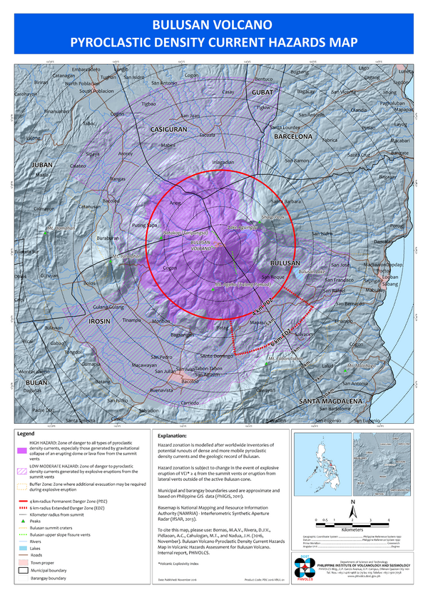
Official, Insert/poster-size map with accompanying report
Bulusan Volcano Pyroclastic Flow Hazard Map
Bornas, M.A.V., Rivera, D.J.V., Pidlaoan, A.C., Cahulogan, M.T., & Nadua, J.H. (2016). Bulusan Volcano Pyroclastic Density Current Hazard Map. in: Volcanic Hazard Assessment for Bulusan Volcano. Philippine Institute of Volcanology and Seismology (PHIVOLCS).