
Advanced Search for Maps
Showing 41-50 of 73
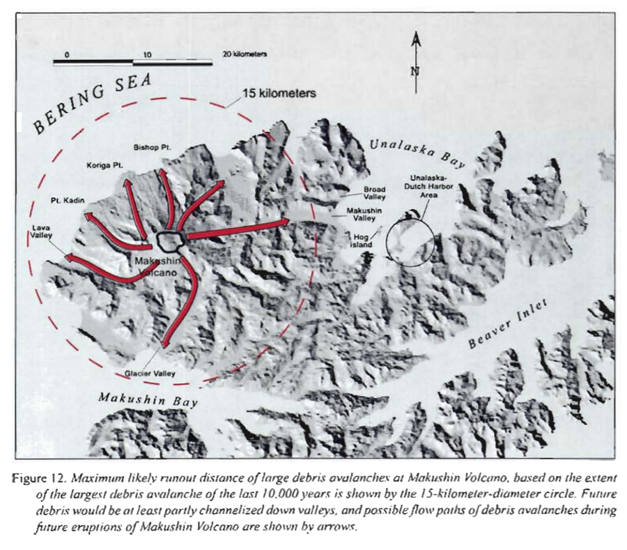
Official, Figure in hazard assessment
Maximum likely runout distance of large debris avalanches at Makushin Volcano
Figure 12 in: Beget, J.E., Nye, C.J. & Bean, K.W. (2000). Preliminary volcano-hazard assessment for Makushin Volcano, Alaska. Alaska Division of Geological & Geophysical Surveys, Report of Investigation 2000-4, 22 p., 1 sheet, scale 1:100,000.
Official, Sign or billboard
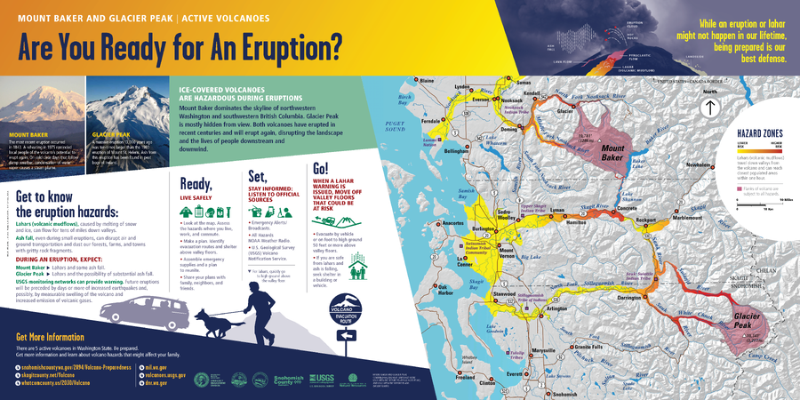
Mount Baker and Glacier Peak | Active Volcanoes. Are You Ready for An Eruption?
Washington Department of Natural Resources. (2014). Mount Baker and Glacier Peak, Active Volcanoes, Are You Ready for An Eruption? Mount Baker And Glacier Peak Combined Hazard Map. (Simplified from: Waitt et al. 1995 and Gardner et al. 1995)
Official, Map sheet or poster
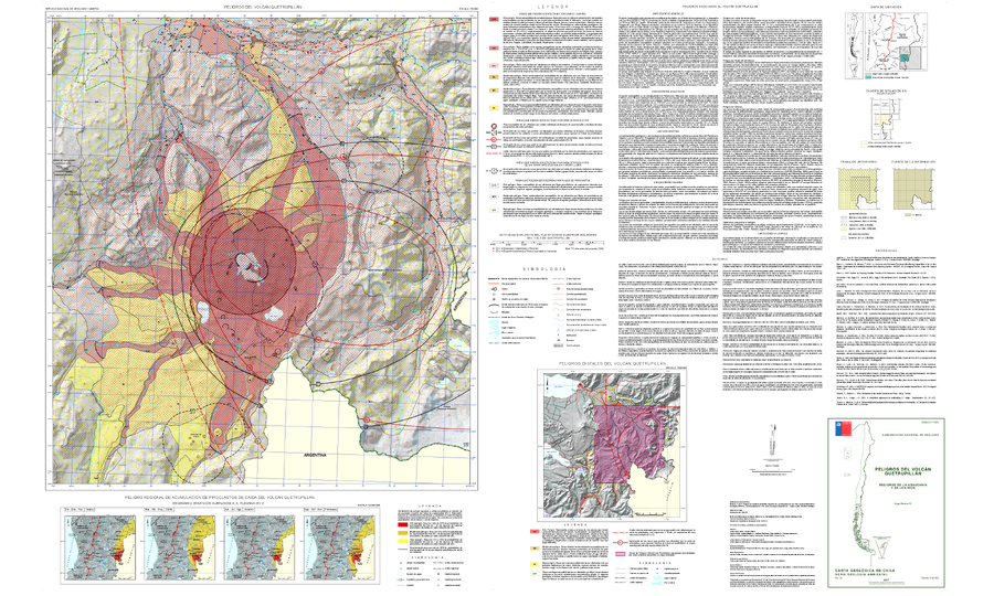
Peligros del Volcán Quetrupillán
(Hazards of the Quetrupillán Volcano)
Moreno, H. (2017). Peligros del Volcán Quetrupillán, Regiones de La Araucanía y de Los Ríos. Servicio Nacional de Geología y Minería, Carta Geológica de Chile, Serie Geología Ambiental 30:1, Escala 1:50.000. Santiago.
Official, Map sheet or poster
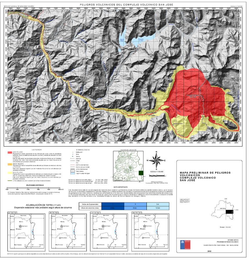
Peligros Volcánicos del Complejo Volcánico San José
(Volcanic Hazards of the San José Volcanic Complex)
Silva, C., Orozco, G., Moreno, H. (2012). Mapa Preliminar de peligros volcánicos Complejo volcánico San José, Región Metropolitana. Informe inédito, Subdirección Nacional de Geología, Programa de Riesgo Volcánico. Escala 1:100.000. Santiago.
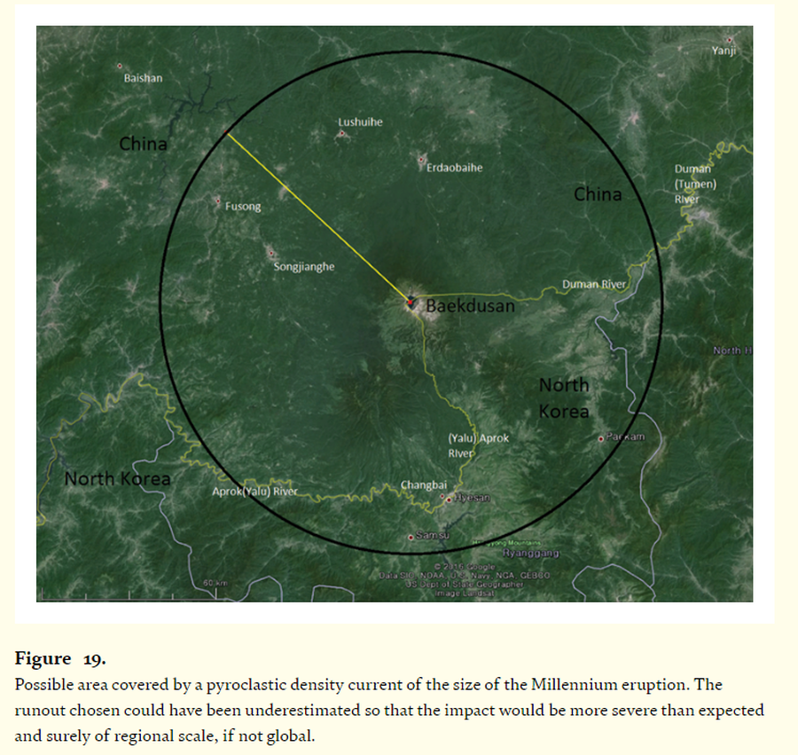
Figure in a journal article
Possible area covered by a pyroclastic density current of the size of the Millennium eruption
Figure 19 in: Paone, A., & Yun, S. H. (2016). Pyroclastic density current hazards at the Baekdusan volcano, Korea: analyses of several scenarios from a small-case to the worst-case colossal eruption. In: Németh, K. (Ed.) Updates in Volcanology-From Volcano Modelling to Volcano Geology. IntechOpen. https://doi.org/10.5772/62340
Official, Unknown format
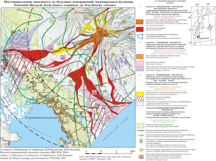
Potential Hazards from future eruptions of Avachinsky volcano
Bazanova, L.I., Braitseva, O.A., Melekestsev, I.V., & Puzankov, M.Yu. (2001). Potential Hazards from future eruptions of Avachinsky volcano. Institute of Volcanic Geology and Geochemistry FED RAS.
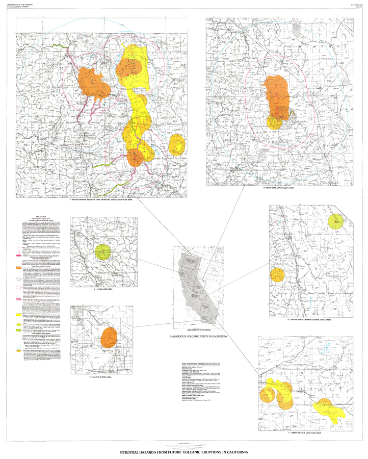
Official, Insert/poster-size map with accompanying report
Potential Hazards from future volcanic eruptions in California
Plate 1 in: Miller, C.D. (1989). Potential hazards from future volcanic eruptions in California. U.S. Geological Survey, Bulletin 1847, 17 p., 2 tables, 1 plate, scale 1:500,000.
Official, Insert/poster-size map with accompanying report
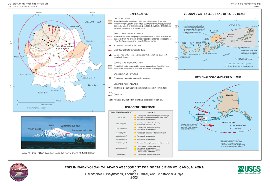
Preliminary Volcano-Hazard Assessment for Great Sitkin Volcano, Alaska
Plate 1 in: Waythomas, C.F., Miller, T.P. & Nye, C.J. (2003). Preliminary volcano-hazard assessment for Great Sitkin Volcano, Alaska. U.S. Geological Survey, Open-File Report 03-112, 25 p., 1 plate. https://doi.org/10.3133/ofr03112
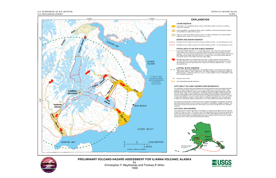
Official, Insert/poster-size map with accompanying report
Preliminary Volcano-Hazard Assessment for Iliamna Volcano, Alaska
Plate 1 in: Waythomas, C.F. & Miller, T.P. (1999). Preliminary volcano-hazard assessment for Iliamna Volcano, Alaska. U.S. Geological Survey, Open-File Report 99-373, 31 p., 1 plate. https://doi.org/10.3133/ofr99373
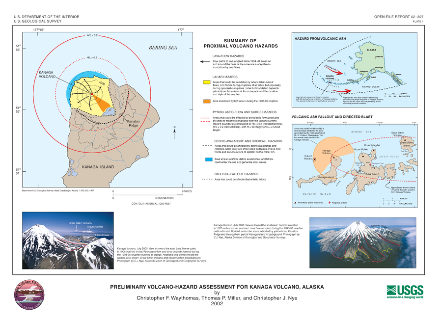
Official, Insert/poster-size map with accompanying report
Preliminary Volcano-Hazard Assessment for Kanaga Volcano, Alaska
Plate 1 in: Waythomas, C.F., Miller, T.P. & Nye, C.J. (2002). Preliminary volcano-hazard assessment for Kanaga Volcano, Alaska. U.S. Geological Survey, Open-File Report 02-0397, 27 p., 1 plate. https://doi.org/10.3133/ofr02397