
Advanced Search for Maps
Showing 61-70 of 73
Official, Map sheet or poster
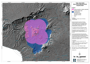
Taal Volcano Ballistic Projectiles Hazards Map
Philippine Institute of Volcanology and Seismology (PHIVOLCS). (2011). Taal Volcano Ballistic Projectiles Hazards Map. Quezon City.
Official, Map sheet or poster
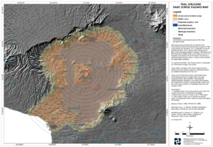
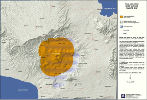
Taal Volcano Base Surge Hazard Map
Philippine Institute of Volcanology and Seismology (PHIVOLCS). (2011). Taal Volcano Base Surge Hazard Map. Quezon City.
Official, Map sheet or poster
Taal Volcano Base Surges Hazard Map
Philippine Institute of Volcanology and Seismology (PHIVOLCS). (2011). Taal Volcano Base Surges Hazard Map. Quezon City.
Official, Map sheet or poster
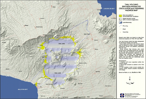
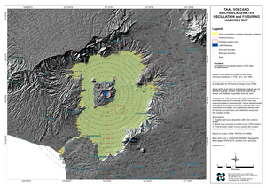
Taal Volcano Seiches/Lakewater Oscillation and Fissuring Hazard Map
Philippine Institute of Volcanology and Seismology (PHIVOLCS). (2011). Taal Volcano Seiches/Lakewater Oscillation and Fissuring Hazard Map. Quezon City.
Official, Map sheet or poster
Taal Volcano Seiches/Lakewater Oscillation and Fissuring Hazards Map
Philippine Institute of Volcanology and Seismology (PHIVOLCS). (2011). Taal Volcano Seiches/Lakewater Oscillation and Fissuring Hazards Map. Quezon City.
Official, Map sheet or poster
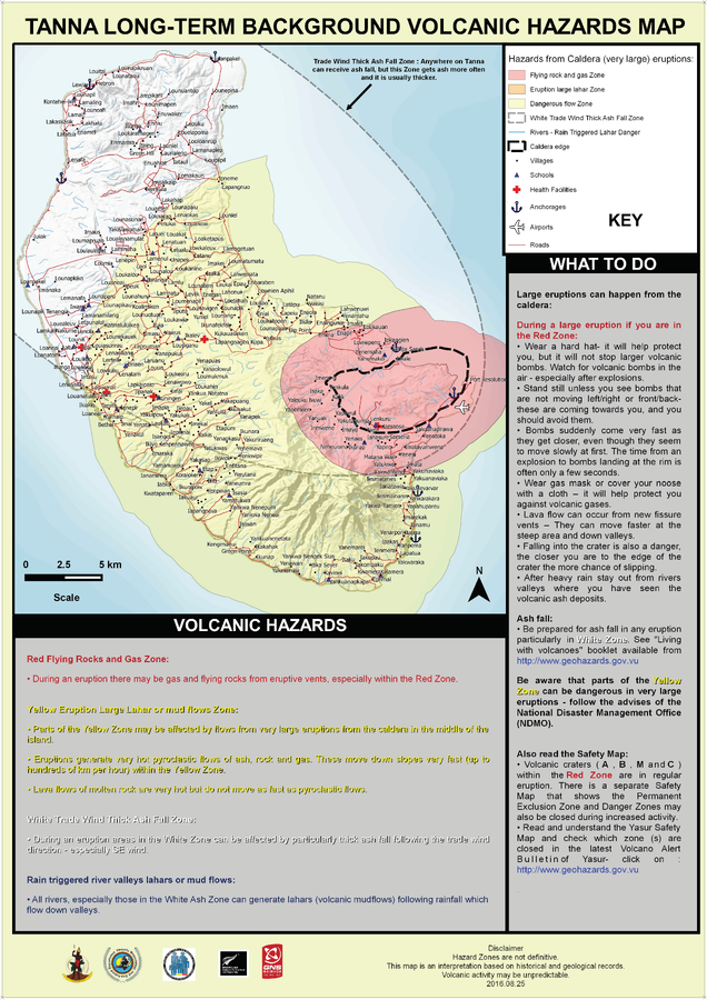
Tanna Long-Term Background Volcanic Hazards Map
Vanuatu Meteorology & Geo-Hazards Department. (2016). Tanna Long-Term Background Volcanic Hazards Map. Government of Vanuatu, Vanuatu Meteorology & Geo-Hazards Department, Vanuatu National Disaster Risk Management Office, New Zealand Foreign Affairs & Trade Aid Programme, GNS Science.
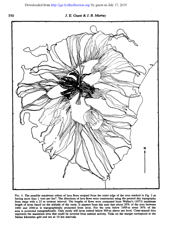
Figure in a journal article
The possible maximum extent of lava flows erupted from the outer edge of the area marked in Fig, 2 as having more than 1 vent per km²
Figure 3 in: Guest, J.E. & Murray, J.B. (1979). An analysis of hazard from Mount Etna volcano. Journal of the Geological Society, 136(3), p. 347-354. https://doi.org/10.1144/gsjgs.136.3.0347
Official, Map sheet or poster
Volcanic disaster prevention map of Azumayama volcano
Volcano Disaster Management Councils of Azumayama. (2019). Volcano Disaster Prevention Map. Fukushima City, Inawashiro City, Yonezawa City.
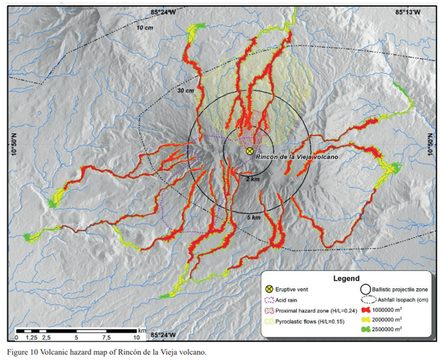
Figure in a journal article
Volcanic hazard map of Rincón de la Vieja volcano
Figure 10 in: Alpízar, Y., Fernández, M., Ramírez, C., & Arroyo, D. (2019). Hazard Map of Rincón de la Vieja Volcano, Costa Rica: Qualitative Integration of Computer Simulations and Geological Data. Anuario do Instituto de Geociencias, 42(3). http://dx.doi.org/10.11137/2019_3_474_488
Official (foreign agency), Insert/poster-size map with accompanying report
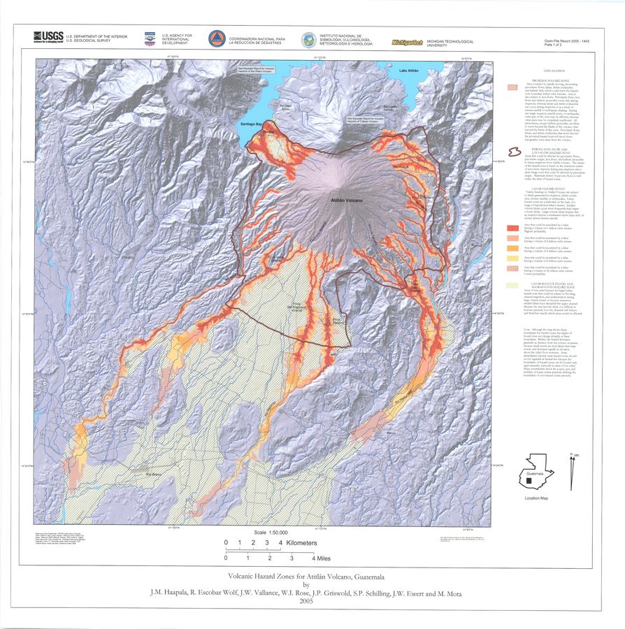
Volcanic Hazard Zones for Atitlán Volcano, Guatemala
Plate 1 in: Haapala, J. M., Escobar Wolf, R., Vallance, J. W., Rose, W. I., Griswold, J. P., Schilling, S. P., Ewert, J.W., & Mota, M. (2005). Volcanic hazards at Atitlan volcano, Guatemala. U.S. Geological Survey, Open-File Report, 1403. https://doi.org/10.3133/ofr20051403